Brandenburg an der Havel
| Brandenburg an der Havel | ||
|---|---|---|
| ||
 Brandenburg an der Havel | ||
| Coordinates: 52°25′0″N 12°32′0″E / 52.41667°N 12.53333°ECoordinates: 52°25′0″N 12°32′0″E / 52.41667°N 12.53333°E | ||
| Country | Germany | |
| State | Brandenburg | |
| District | Urban district | |
| Government | ||
| • Lord Mayor | Dr. Dietlind Tiemann (CDU) | |
| Area | ||
| • Total | 228.80 km2 (88.34 sq mi) | |
| Population (2015-12-31)[1] | ||
| • Total | 71,574 | |
| • Density | 310/km2 (810/sq mi) | |
| Time zone | CET/CEST (UTC+1/+2) | |
| Postal codes | 14772–14778 | |
| Dialling codes | 03381 | |
| Vehicle registration | BRB | |
| Website | www.stadt-brandenburg.de | |

Brandenburg an der Havel is a town in the state of Brandenburg (which is why it is also called Brandenburg City in English), Germany, with a population of 71,778 (as of 2010). It is located on the banks of the River Havel. The town of Brandenburg, which is almost as widely known as the state of Brandenburg, provided the name for the medieval Bishopric of Brandenburg, the Margraviate of Brandenburg, and the current state of Brandenburg. Today it is a small town compared to nearby Berlin, but it was the original nucleus of the former realms of Brandenburg and Prussia.
History
Middle Ages
The castle of Brandenburg, which had been a fortress of the Slavic tribe Stodoranie, was conquered in 929 by King Henry the Fowler. The name of the city in the local Slavic language is Brennabor and is a combination of two words brenna' - defense and bor - fort. The town remained German only until 983, when a Slavic rebellion was successful. During the next 170 years the area was ruled by Slavic princes of the Hevelli tribe. The last of them, Pribislav, died in 1150. From 1153/1154 to 1157 Brennabor was part of the Slavonic Duchy of Kopanica, a fief of Poland. Afterwards Albert I settled here and became the first margrave of Brandenburg. The town was restricted to the western bank of the Havel until 1196, when it was extended to the eastern side. The parts on either side of the river were regarded as three different towns (Old Town, New Town and Brandenburg cathedral district) for centuries.
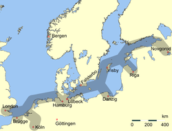
In 1314–1315 the Old and New Towns joined the Hanseatic League. In the Thirty Years' War (1618–1648) the towns suffered plundering and destruction which led to a loss of power; Potsdam became the new capital, and the court left the town of Brandenburg. In 1715 Old Town and New Town were merged to form a single town. In 1928 the Brandenburg cathedral district was added.
Modern history
In the late 19th century Brandenburg an der Havel became a very important industrial center in the German Empire. Steel industries settled there, and several world famous bicycle brands such as Brennabor, Corona and Excelsior were manufactured in the city. A world famous toy industry was also established. With a giant industrial complex, the Deutsche Reichsbahn (German Imperial Railways) was located in Brandenburg-Kirchmöser during the time between the two world wars and the time of the former GDR. The city's excellent transport infrastructure was a big advantage.
In 193/34, a concentration camp, one of the first in Nazi Germany, was located on Neuendorfer Straße in Brandenburg Old Town. After closing this inner city concentration camp, the Nazis used the Brandenburg-Görden Prison, located in the suburb of Görden. Later the old gaol became the Brandenburg Euthanasia Centre where the Nazis killed people with mental diseases, including children. They called this operation "Action T4" because of the Berlin address, Tiergartenstraße 4, the headquarters of this planned and well-organized forced euthanasia organisation. Brandenburg an der Havel was one of the very first locations in the Third Reich where the Nazis experimented with killing their victims by gas. Here, they prepared the mass killings in Auschwitz and other extermination camps. After complaints by local inhabitants about the smoke, the mobile furnaces used to burn the corpses ceased operation. Shortly after this, the Nazis closed the old prison.
In 1934, the Arado Aircraft Company (Arado Flugzeugwerke), which originated in Warnemünde, built a satellite factory in Brandenburg that began producing planes in 1935. The factory was expanded over the next five years, and produced trainers and other aircraft for the Luftwaffe during World War II. The existence of this factory was one of the reasons Brandenburg was heavily bombed in later stages of the war; by 1945, 70% of the city was destroyed.
Friedrich Fromm, a German officer involved in the July 20 plot to assassinate Hitler, was executed here in March 1945 for his part in the plot, even though Fromm betrayed those conspirators he knew and ordered their execution.
After German reunification the city's population declined from over 100,000 in 1989 to roughly 75,000 in 2005 through emigration. The migration was mainly by young people.
Demography
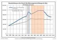 Development of Population since 1875 within the Current Boundaries (Blue Line: Population; Dotted Line: Comparison to Population Development of Brandenburg state; Grey Background: Time of Nazi rule; Red Background: Time of Communist rule)
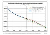 Recent Population Development (Blue Line) and Forecasts
|
|
|
|
Transport
The city is located on the navigable River Havel, a European Waterway, and vessels travelling through the city have a choice of two routes. The original route used the Brandenburg City Canal, a 4-kilometre (2.5 mi) route through the city centre that descends through the Stadtschleuse Brandenburg, but this route is constrained in size and now limited to leisure craft. Commercial traffic instead uses the Silo Canal that passes through the eastern and northern fringes of the city.[3]
The city is located at the junction of Federal Highways 1 and 102 and the A2 autobahn is nearby. The Berlin and Magdeburg railway also runs through Brandenburg an der Havel.
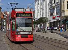
The centrepiece of the city's urban public transport system is the Brandenburg an der Havel tramway network.
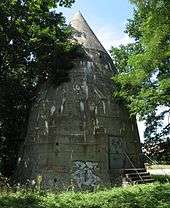
Sights
.jpg)
The Dominsel (Cathedral Island) is the historic heart of the town. Here stands its oldest edifice: the Dom St. Peter und Paul (Cathedral of Saints Peter and Paul). Although construction began in the Romanesque style in 1165, it was completed as a Gothic cathedral during the 14th century. While the exterior is rather austere, the cathedral surprises the visitor with its sumptuous interior, especially the painted vault of the Bunte Kapelle (Coloured Chapel) and the Wagner organ (1725), one of the most famous Baroque organs in Germany.
The Katharinenkirche (St. Catherine's Church) built in 1401 in the Neustadt is an impressive example of northern German brick Gothic architecture. The Gotthardtkirche (St. Gotthardt's Church) was built of the same material just a few years later.
Another interesting building is the Altstädtisches Rathaus (Old Town Hall), a late Gothic brick building with stepped gables and an ornate portal. In front of it stands a 5.35m high statue of the knight Roland. Made of sandstone, the statue was erected in 1474 as a symbol of the town's independence.
There is also a part of Brandenburg's medieval city wall, with four preserved watchtowers: Steintorturm and Mühlentorturm (in the New Town), and Rathenower Torturm and Plauer Torturm (in the Old Town).
The Brandenburg Industrial Museum is an Anchor Point of ERIH, The European Route of Industrial Heritage. Brandenburg has its own theatre (Brandenburger Theater), a professional symphony orchestra (Brandenburger Symphoniker) and a wide range of local history and archaeology museums.
 Brandenburg Cathedral
 St. Gotthardt's Church
 Altstädtischer Markt, Old Town Hall
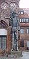 Roland statue in front of the Old Town Hall
 Steintorturm
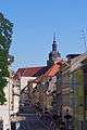 Hauptstraße and St. Catherine's Church
 St. Catherine's Church
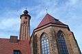 Archaeological Museum (former St. Paul's Church)
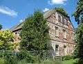 Manor in Mahlenzien
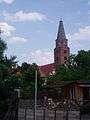
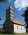 Church in Mahlenzien
Notable residents

- Vicco von Bülow (1923–2011), known as Loriot, German comedian, humorist, cartoonist, film director, actor and writer
- Gustav Noske, (1868-1946), German politician (SPD), Minister of Defence between 1919 and 1920
- Joachim Kemmer, (1939-2000), film actor
- Judith of Poland, (c. 1130/35-1171/75), buried in the cathedral
- Józef Unrug, (1884-1973), Polish vice admiral, was born here
Sons and daughters of the town
(By year of birth in Brandenburg an der Havel)
- Georg Sabinus ( Georg Schuler ; 1508-1560), professor of poetry and rhetoric, founding rector of the University of Königsberg and a professor at the Brandenburg University Frankfurt (Oder)
- Christian Konrad Sprengel (1750-1816), theologian, botanist and naturalist
- Julius von Voss (1768-1832), officer, writer
- Friedrich de la Motte-Fouque (1777-1843), writer
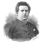
- Theodor Hosemann (1807-1875), painter, illustrator and cartoonist in Berlin
- Wilhelm Rüstow (1821-1878), freedom fighter and revolutionary, military writer and historian
- Ludwig Chronegk (1837-1891), actor and director of the Meiningen Court Theatre
Twin towns
-
 Ivry-sur-Seine, France
 -
 Kaiserslautern, Germany
 -
 Magnitogorsk, Russia
 -
 Bitola, Macedonia
See also
- Brandenburg Euthanasia Centre
- Brandenburg Gate in Berlin
- Brandenburg Central Station
- FC Stahl Brandenburg
- Brandenburger SC Süd 05
- Nikolaus von Halem
References
- ↑ "Bevölkerung im Land Brandenburg nach amtsfreien Gemeinden, Ämtern und Gemeinden 31. Dezember 2015 (Fortgeschriebene amtliche Einwohnerzahlen auf Grundlage des Zensus 2011)". Amt für Statistik Berlin-Brandenburg (in German). 2016.
- ↑ Detailed data sources are to be found in the Wikimedia Commons.Population Projection Brandenburg at Wikimedia Commons
- ↑ Sheffield, Barry (1995). Inland Waterways of Germany. St Ives: Imray Laurie Norie & Wilson. pp. 93–100. ISBN 0-85288-283-1.
External links
| Wikivoyage has a travel guide for Brandenburg an der Havel. |
| Wikimedia Commons has media related to Brandenburg an der Havel. |
| Wikisource has the text of the 1911 Encyclopædia Britannica article Brandenburg (town). |
| Wikisource has the text of a 1920 Encyclopedia Americana article about Brandenburg an der Havel. |
- (German) Municipal website
- (German) Cathedral of Brandenburg
- (German) City map
- (German) Inner City Brandenburg guide
- Tramway in Brandenburg
- Potsdamer Brandenburger Havelseen, Tourist information
| Urban districts | |
|---|---|
| Rural districts | |
Members of the Hanseatic League by Quarter | |||||||
|---|---|---|---|---|---|---|---|
| |||||||
| Wendish |
|  | |||||
| Saxon | |||||||
| Baltic | |||||||
| Westphalian | |||||||
| Kontore |
| ||||||
| Other cities | |||||||