Branko's Bridge
| Branko's Bridge Бранков мост Brankov most | |
|---|---|
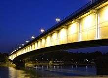 Branko's bridge at night | |
| Official name | Бранков мост / Brankov most |
| Characteristics | |
| Total length | 450 m |
| Longest span | 261 m |
| History | |
| Opened | 1957 |
| Statistics | |
| Daily traffic | 90,000 vehicles |
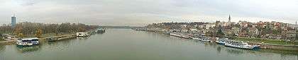
Branko's bridge (Serbian: Бранков мост / Brankov most) is the second-largest bridge (after Gazela) of Belgrade, Serbia, connecting the city center with New Belgrade across Sava river.
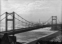
The bridge was built in 1957,[1] replacing the former chain-stayed King Aleksandar I Bridge (built by the Société de Construction des Batignolles) that was opened on December 16, 1934 and blown up in 1941.[2] The bridge actually uses lower parts of the former bridge's pylons (decorated by Ivan Meštrović in Serbo-Byzantium style) as outer constraints for its two secondary spans. It has dual carriageway with three lanes in both directions; actually, it consists of two separate constructions in each direction, and the second was finished in 1979. It is 450 m long, made as continuous steel box girder, with central span of 261 m and side spans of 81.5 m each. It is crossed by nearly 90,000 vehicles daily, and traffic congestions are frequent.[3]
German company MAN is behind the original project of the bridge. Belgrade-based "Mostprojekt" company executed the project of doubling the bridge capacity in the 1970s. Head of the project team was Danilo Dragojević.[4]
The name of the bridge is unofficial, and seems to owe it to a bizarre chain of events. Its official name during the communist rule was "Brotherhood and unity bridge" (Most bratstva i jedinstva), but that name never caught up: it was called "bridge in Branko's street" (named after Branko Radičević, Serbian romanticist poet) or "Savski most" (Sava bridge). However, when another writer, Branko Ćopić, committed a suicide by jumping from the bridge in 1984, the current name started circulating and eventually caught up; it is still not clear after which Branko it was named.[5][6]
See also
External links
- Fanovi "Stonsa" opasno zaljuljali Brankov most, Blic, 17. jul 2007
- http://www.blic.rs/Vesti/Beograd/92810/Policija-nije-dala-da-veceraju-na-Brankovom-mostu
References
- ↑ "Arhiv: 16. decembar" (in Serbian). Danas. 2003-12-16.
- ↑ "Twentieth Century - Innovations in Belgrade (1930-1950)". Serbia-info.com. Archived from the original on 2008-01-18.
- ↑ "Cevovod na Brankovom mostu". Direkcija za građevinsko zemljište i izgradnju Beograda. 2006-08-02.
- ↑ "Malo ih je, ali su značajni" (in Serbian). 2008-01-14.
- ↑ "Brankov most" (in Serbian).
- ↑ "Sporno ime mosta" (in Serbian). 2000-02-21.
Coordinates: 44°48′53″N 20°26′54″E / 44.81472°N 20.44833°E
| Wikimedia Commons has media related to Branko's Bridge. |