Sava
| Sava | |
| River | |
 | |
| Countries | Slovenia, Croatia, Bosnia-Herzegovina, Serbia |
|---|---|
| Tributaries | |
| - left | Savinja, Sutla, Krapina, Lonja, Ilova-Trebež, Orljava, Bosut |
| - right | Ljubljanica, Krka, Kupa, Una, Vrbas, Ukrina, Bosna, Tinja, Drina, Kolubara |
| Cities | Kranj, Ljubljana, Zagreb, Sisak, Slavonski Brod, Brčko, Sremska Mitrovica, Šabac, Obrenovac, Belgrade |
| Source | Zelenci |
| - location | Kranjska Gora, Slovenia |
| - elevation | 833 m (2,733 ft) |
| - coordinates | 46°29′31″N 13°44′16″E / 46.49194°N 13.73778°E |
| Mouth | Danube |
| - location | Belgrade, Serbia |
| - elevation | 68 m (223 ft) |
| - coordinates | 44°49′27″N 20°26′38″E / 44.82417°N 20.44389°ECoordinates: 44°49′27″N 20°26′38″E / 44.82417°N 20.44389°E |
| Length | 990 km (615 mi) a |
| Basin | 97,713.2 km2 (37,727 sq mi) |
| Discharge | for the river mouth |
| - average | 1,609 m3/s (56,821 cu ft/s) |
 Map of the Sava watershed
| |
| a Including 45 km (28 mi) Sava Dolinka headwater | |
The Sava (Slovene pronunciation: [ˈsàːʋa],[1] Serbo-Croatian: [sǎːʋa],[2] Serbian Cyrillic: Сава) is a river in Central Europe, a right side tributary of the Danube. It flows through Slovenia, Croatia, along the northern border of Bosnia and Herzegovina, through Serbia, discharging into the Danube in Belgrade. Its central part is a natural border of Bosnia-Herzegovina and Croatia. The Sava forms the northern border of the Balkan Peninsula, and southern edge of the Pannonian Plain.
The Sava is 990 kilometres (615 miles) long, including the 45-kilometre (28 mi) Sava Dolinka headwater rising in Zelenci, Slovenia. It is the greatest tributary of the Danube by volume of water, and second-largest after Tisza in terms of catchment area (97,713 square kilometres (37,727 square miles)) and length. It drains a significant portion of the Dinaric Alps region, through the major tributaries of Drina, Bosna, Kupa, Una, Vrbas, Lonja, Kolubara, Bosut and Krka. The Sava is one of the longest rivers in Europe and among a handful of European rivers of that length that do not drain directly into a sea.
The population in the Sava River basin is estimated at 8,176,000, and it connects three national capitals—Ljubljana, Zagreb and Belgrade. The Sava is navigable for larger vessels from the confluence of the Kupa River in Sisak, Croatia, approximately two-thirds of its length.
Sources
The Sava River is formed from the Sava Dolinka and the Sava Bohinjka headwaters in northwest Slovenia. The river's headwater area also encompasses several tributaries, including the 52-kilometre (32 mi) Sora, the 27-kilometre (17 mi) Tržič Bistrica and the 17-kilometre (11 mi) Radovna rivers—flowing into the Sava at confluences located as far east downstream as Medvode.[3][4]
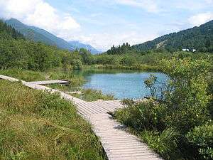
The Sava Dolinka rises at the Zelenci Pools near Kranjska Gora, Slovenia, in a valley separating the Julian Alps from the Karavanke mountain range.[5] The spring is located near the Slovene-Italian border at 833 metres (2,733 feet) above sea level,[4][6] in a drainage divide between the Adriatic and Danube basins. The Sava Dolinka spring is fed by groundwater possibly exhibiting bifurcation of source karst aquifer to the Sava and Soča basins.[7] Nadiža creek, a short losing stream flowing nearby, is the source of Zelenci Pools water.[5] The Sava Dolinka is considered the Sava's initial,[4] 45-kilometre (28 mi) segment.[8]
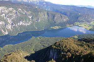
The Sava Bohinjka originates in Ribčev Laz, at the confluence of the Jezernica,[9] a short watercourse flowing out from Lake Bohinj and the Mostnica River.[10] Some sources define the Jezernica as a part of the Sava Bohinjka, specifying the latter as flowing directly out of the lake,[11] while another group of sources include Savica, rising at the southern flank of Triglav as the 78-metre (256 ft) Savica Falls,[12] downstream from Triglav Lakes Valley, and flowing into the lake, as a part of the Sava Bohinjka.[13] The watercourse flows 41 kilometres (25 miles)—including the length of the Savica—east to Radovljica,[4] where it discharges into the Sava Dolinka. Downstream from the confluence, the river is referred to as the Sava.[7]
Course

The Sava is located in Southeast Europe, flowing through Slovenia, Croatia, Serbia and along the Bosnia-Herzegovina border. Its total length is 990 kilometres (615 miles), including the 45-kilometre (28 mi) Sava Dolinka and the 945-kilometre (587 mi) Sava proper. As a right tributary of the Danube, the river belongs to the Black Sea drainage basin.[14][15] The Sava River is the third longest tributary of the Danube,[16] slightly shorter than the 966-kilometre (600 mi) Tisza and the 950-kilometre (590 mi) Prut—the Danube's two longest tributaries—when the Sava Dolinka headwater is excluded from its course.[17][18] It is also the largest tributary of the Danube by discharge.[16] The river course is sometimes used to describe the northern boundary of the Balkans,[19] and the southern border of the Central Europe.[20] Before the breakup of Yugoslavia in 1991, the river was located completely inside Yugoslav borders and it was the longest river with its entire course within the country.[21]
From source to the Sutla
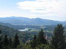
The Sava Dolinka rises in the Zelenci Pools, west of Podkoren in the Upper Carniola region of Slovenia at 833 metres (2,733 feet) above sea level (a.s.l.),[4][6] and flows east, past Kranjska Gora to Jesenice, where it turns southeast. At Žirovnica, the river enters the Ljubljana Basin and encounters the first hydroelectric dam—Moste plant—before proceeding to the east of the glacial Lake Bled towards Radovljica and confluence of the Sava Bohinjka,[22] at 411 metres (1,348 feet) a.s.l.[4] Downstream of Radovljica, the Sava proceeds southeast towards Kranj. Between Kranj and Medvode, its course comprises the Lake Trboje and the Lake Zbilje reservoirs,[23] built for the Mavčiče and the Medvode power plants.[24][25]
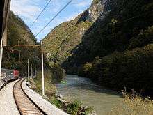
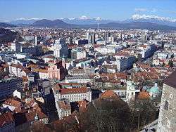
The Sava then flows through the capital of Slovenia, Ljubljana,[26] where another reservoir is located on the river, adjacent to the Tacen Whitewater Course.[27] There the river course turns east and leaves the Ljubljana Basin via Dolsko,[28] at 261 metres (856 feet) a.s.l. (at confluence of the Ljubljanica and the Kamnik Bistrica).[4] The course continues through the Sava Hills, where it passes the Litija Basin with the mining and industrial town of Litija, the Central Sava Valley with the mining towns of Zagorje ob Savi, Trbovlje, and Hrastnik, turns to the southeast and runs through the Lower Sava Valley with the towns of Radeče, Sevnica, and Krško. The course through the Sava Hills forms the boundary of traditional regions of Lower Carniola and Styria,[29] At Radeče, the Vrhovo hydroelectric dam reservoir is located.[30] The latter is site of the Krško Nuclear Power Plant, which uses the Sava River water to dissipate excess heat.[31] The easternmost stretch of the Sava River course in Slovenia runs to the south of Brežice, where it is joined by the Krka, and the river ultimately becomes a border river between Slovenia and Croatia, marking 4 kilometres (2.5 miles) of their border near confluence of the Sutla (Slovene: Sotla).[32] At that point, the Sava reaches 132 metres (433 feet) a.s.l. after flowing 221 kilometres (137 miles) through Slovenia and along its border.[4]
From the Sutla to the Una

The westernmost part of the 562-kilometre (349 mi) Sava River course in Croatia,[35] takes the river east, through the western part of the Zagreb County, between Samobor and Zaprešić. The area encompasses forests interspersed by marshes and lakes formed in gravel pits.[36] As the Sava approaches the capital of Croatia, Zagreb, the marshes give way to urban landscape, but there are surviving examples of the gravel pit lakes, such as the Jarun,[37] and the Bundek within the city.[38] At the western outskirts of Zagreb, there is the western terminus of the 32-kilometre (20 mi) Sava–Odra flood-relief canal connecting the Sava to the Odra River plain which is intended to act as flood control retention basin.[39] The canal has been built in response to the most destructive flooding of the river that occurred in Zagreb in 1964, when one third of the city was flooded and 17 people were killed.[40] The city itself marks the western extent of the Sava River basin area especially prone to flooding, spanning from Zagreb to confluence of the river in Belgrade, Serbia.[41]
East of Zagreb, the river turns southeast again further through the Central Croatia, to the Sisak-Moslavina County, the city of Sisak, reaching 91.3 metres (300 feet) a.s.l. The city of Sisak marks the westernmost extent of the Sava River navigable to larger vessels. Navigation conditions on the river are poor due to limited draft and fairway width, meandering of the river, bridge clearance restrictions, poor fairway markings as well as presence of sunken vessels and other objects, including unexploded ordnance.[42] The ordnance is left over from various conflicts including the World War II,[43] Croatian War of Independence, Bosnian War,[44] and the 1999 NATO bombing of Yugoslavia.[45] Before reaching confluence of Una at Jasenovac and 86.8 metres (285 feet) a.s.l,[46] the Sava River traces Lonjsko polje Nature Park,[47] encompassing marshes frequently flooded by the Sava and its tributaries in the area.[48]
From the Una to the Drina

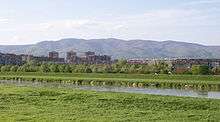
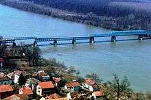
Downstream of confluence of the Una River, the Sava is once again tracing an international border—between Croatia and Bosnia-Herzegovina. Its meandering course turns generally eastwards along Gradiška, and Slavonski Brod to Županja, where it turns south to Brčko. There, the river resumes its predominantly eastward course towards Sremska Rača and confluence of the Drina River. The right bank of the Sava, in this segment of its course, belongs to Bosnia-Herzegovina (with Bosnia's all three administrative entities, Republika Srpska, Federation of Bosnia and Herzegovina and the Brčko District, having gateway to the river), while the opposite bank belongs to Croatia and its Sisak-Moslavina, Brod-Posavina and Vukovar-Srijem counties, except in the area of Jamena and further downstream—which belongs to Serbia and the province of Vojvodina. No cities in this segment of the course span the river as it represents an international frontier, but there are adjacent settlements located in two different countries, divided by the Sava. Those include Gradiška, Brod and Brčko in Bosnia-Herzegovina and Stara Gradiška, Slavonski Brod and Gunja in Croatia opposite them.
The 337.2-kilometre (209.5 mi) segment between the Una and the Drina confluences, marking corresponding to the entire length of the Sava flowing along the border of Bosnia-Herzegovina, exhibits small change of elevation—from 86.8 metres (285 feet) a.s.l at Jasenovac to 76.6 metres (251 feet) a.s.l. at Brčko gauges, over 287.5 kilometres (178.6 miles) of the river between them.[50] The entire course of the river downstream from Zagreb flows down 0.4‰ slope on average, significantly less steep than the course in Slovenia, where the average slope exceeds 0.7‰—resulting in the Sava's meandering course running through a wide plain bordered by wetlands.[6]
From the Drina to the Danube
.JPG)

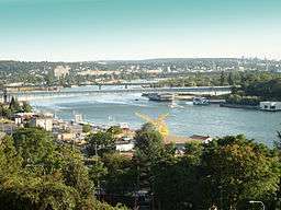
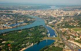
Downstream from confluence of the Drina, the Sava River changes its eastward course to northeast, until it reaches Sremska Mitrovica, from where it flows to the southeast and then south to Šabac, before finally turning east towards Belgrade. Most of the river's course in Serbia represents a border between province of Vojvodina, on the left bank, and Central Serbia, on the right bank. Exceptions to that are in area around Sremska Mitrovica, where both banks are in Vojvodina, and downstream of Progar suburb of Belgrade where both banks are in Central Serbia. The river meanders and forms wetlands in there as well—the most significant wetland among them centering on Obedska bara oxbow lake.[8] The Sava River forms several large islands in this segment of the course, with the largest among them—800-hectare (2,000-acre) Ada Ciganlija in Belgrade—connected to the right bank by a pair of artificial embankment dams forming Lake Sava since 1967.[51][52]
The Sava discharges into the Danube, after reaching 68.3 metres (224 feet) a.s.l. as its right tributary at the Great War Island off the easternmost tip of Syrmia in Belgrade, 1,169.9 kilometres (726.9 miles) away from the Danube's confluence and the Black Sea.[53]
Settlements
Population in the Sava River basin is estimated at 8,176,000, and it includes four capitals—Belgrade, Ljubljana, Sarajevo and Zagreb. All of them, except Sarajevo, are also located directly on the river banks and represent the three largest settlements found along the Sava River course.[54] Belgrade, located at the confluence of the river, is the largest city in the basin with urban population of 1,135,502. Ten municipalities where the city is situated have combined population of 1,283,783 as suburban settlements are added, while the Belgrade metropolitan area encompasses population of 1,639,121.[55] Zagreb is the second largest city on the river, comprising population of 688,163 living in the city itself, and 790,017 in the city-administered area.[56] Together with the Zagreb County, largely corresponding to various definitions of the city's metropolitan area,[57] it has a combined population of 1,110,517.[56] Ljubljana is the third-largest city on the banks of the Sava, encompassing population of 258,873 living in the city itself and 265,881 in the city-governed area.[58][59]
The largest city in Bosnia-Herzegovina situated on the Sava River course is Brčko, whose urban population is estimated at 40,000.[60] Other cities along the river, with populations of 20,000 and larger, are Slavonski Brod (53,473), Šabac (52,822), Sremska Mitrovica (37,586), Kranj (35,587),[61] Sisak (33,049),[56] Obrenovac (24,568),[62] and Gradiška (est. 20,000).[63]
| The most populous urban areas along the Sava River | ||||||||||
|---|---|---|---|---|---|---|---|---|---|---|
| Rank | City | Country | Urban population | Municipal population | ||||||
| 1 | Belgrade | Serbia | 1,233,350 | 1,659,440 | ||||||
| 2 | Zagreb | Croatia | 688,163 | 1,110,517 | ||||||
| 3 | Ljubljana | Slovenia | 258,873 | 265,881 | ||||||
| 4 | Slavonski Brod | Croatia | 53,473 | 59,507 | ||||||
| 5 | Šabac | Serbia | 52,822 | 115,347 | ||||||
| 6 | Brčko | Bosnia-Herzegovina | 40,000 | 85,000 | ||||||
| 7 | Sremska Mitrovica | Serbia | 37,586 | 79,773 | ||||||
| 8 | Kranj | Slovenia | 35,587 | 51,225 | ||||||
| 9 | Sisak | Croatia | 33,322 | 47,768 | ||||||
| 10 | Obrenovac | Serbia | 24,568 | 71,419 | ||||||
| Sources: Statistical Office of the Republic of Serbia 2011 Census;[64] Croatian Bureau of Statistics, 2011 Census;[56] Statistical Office of the Republic of Slovenia, 2002 Census;[65] Council of Ministers of Bosnia and Herzegovina[60] | ||||||||||
Watershed
The Sava River basin covers a total area of 97,713.2 square kilometres (37,727.3 square miles) making it the second largest Danube tributary catchment by area size, surpassed only by the Tisza basin,[6] and it encompasses 12% of the Danube basin, draining into the Black Sea. The Sava represents the third longest tributary of the Danube and its largest tributary by discharge.[16] The catchment area borders the remainder of the Danube basin to the north and east, and the Adriatic Sea basin to the west and south. The river basin generally consists of parts of Bosnia-Herzegovina, Croatia, Montenegro, Serbia and Slovenia, with a very small part of the catchment area belonging to Albania. Topography of the basin varies significantly. Upstream portion of the basin is more rugged than downstream one, but asymmetry of the basin topography is particularly apparent when comparing right and left bank areas—the former dominated by the Alps and the Dinarides reaching elevations in excess of 2,000 metres (6,600 feet) a.s.l, while the latter is dominated by the Pannonian Plain. The mean elevation of the basin is 545 metres (1,788 feet) a.s.l.[68]
| Country | Sava basin area | Share of national territory in the basin | Share of the Sava basin |
|---|---|---|---|
| Slovenia | 11,734.8 km2 (4,530.8 sq mi) | 52.8% | 12.01% |
| Croatia | 25,373.5 km2 (9,796.8 sq mi) | 45.2% | 25.97% |
| Bosnia-Herzegovina | 38,349.1 km2 (14,806.7 sq mi) | 75.8% | 39.25% |
| Serbia | 15,147.0 km2 (5,848.3 sq mi) | 17.4% | 15.50% |
| Montenegro | 6,929.8 km2 (2,675.6 sq mi) | 49.6% | 7.09% |
| Albania | 179.0 km2 (69.1 sq mi) | 0.59% | 0.18% |
| Source: International Sava River Basin Commission;[69] | |||
Major tributaries

The most important tributaries of the Sava River found in its upper basin are characterized by relatively steep grades of flow, high flow velocities and rapids. Those are left tributaries: the Kokra, the Kamnik Bistrica and the Savinja; and right tributaries: the Sora, the Ljubljanica and the Krka (Sava). Further downstream larger rivers empty into the Sava, as the right bank of the basin grows steadily. Right tributaries in this lower segment of the basin start as fast flowing courses, only to slow down as they enter the Pannonian Basin. They include the Kupa, the Una, the Vrbas, the Ukrina, the Bosna, the Brka, the Tinja, the Drina and the Kolubara. Left tributaries in the lower segment drain plains consequently exhibiting less steep course grades, lower flow rates and meandering. They include the Sutla, the Krapina, the Lonja, the Ilova, the Orljava and the Bosut.[70]
The 346-kilometre (215 mi) Drina is the largest tributary of the Sava, flowing in Bosnia-Herzegovina and along border of the country and Serbia. It is formed by the headwaters of the Tara and the Piva at the border of Bosnia-Herzegovina and Montenegro, near Šćepan Polje. Its 20,319.9-square-kilometre (7,845.6 sq mi) catchment extends across parts of four countries—reaching as far south as Albania. The Bosna and the Kupa river basins are the second and third largest catchments of the Sava tributaries, each surpassing 10,000 square kilometres (3,900 square miles) in size.[70]
| List of major tributaries of the Sava River | ||||||||
|---|---|---|---|---|---|---|---|---|
| Left bank | Catchment area | Length | Confluence | Right bank | ||||
| Country | Region/County | Tributary | Tributary | Region/County | Country | |||
| Slovenia | Central Slovenia | 1,860.0 km2 (718.2 sq mi) | 41.0 km (25.5 mi) | 46°04′32″N 14°38′31″E / 46.075553°N 14.641857°E | Ljubljanica | Central Slovenia | Slovenia | |
| Savinja | Savinja | 1,849.0 km2 (713.9 sq mi) | 93.9 km (58.3 mi) | 46°05′09″N 15°10′42″E / 46.085733°N 15.178471°E | Savinja | |||
| Lower Sava | 2,247.0 km2 (867.6 sq mi) | 94.6 km (58.8 mi) | 45°53′38″N 15°36′04″E / 45.893772°N 15.601187°E | Krka | Lower Sava | |||
| Croatia | Zagreb | Sutla | 584.3 km2 (225.6 sq mi) | 88.6 km (55.1 mi) | 45°51′50″N 15°41′05″E / 45.864015°N 15.684614°E | |||
| Krapina | 1,237.0 km2 (477.6 sq mi) | 66.9 km (41.6 mi) | 45°49′38″N 15°49′24″E / 45.827244°N 15.823359°E | Zagreb | Croatia | |||
| Sisak-Moslavina | 10,225.6 km2 (3,948.1 sq mi) | 297.4 km (184.8 mi) | 45°27′39″N 16°23′54″E / 45.460793°N 16.398296°E | Kupa | Sisak-Moslavina | |||
| Lonja | 4,259.0 km2 (1,644.4 sq mi) | 49.1 km (30.5 mi) | 45°21′50″N 16°45′14″E / 45.363846°N 16.753807°E | |||||
| Ilova-Trebež | 1,796.0 km2 (693.4 sq mi) | 104.6 km (65.0 mi) | 45°20′55″N 16°46′21″E / 45.348707°N 16.772604°E | |||||
| 9,828.9 km2 (3,795.0 sq mi) | 214.6 km (133.3 mi) | 45°16′15″N 16°55′07″E / 45.27096°N 16.918516°E | Una | Border river at the confluence | ||||
| Brod-Posavina | 6,273.8 km2 (2,422.3 sq mi) | 249.7 km (155.2 mi) | 45°06′29″N 17°30′48″E / 45.107939°N 17.51328°E | Vrbas | Republika Srpska | Bosnia-Herzegovina | ||
| Orljava | 1,618.0 km2 (624.7 sq mi) | 87.6 km (54.4 mi) | 45°06′24″N 17°43′29″E / 45.106773°N 17.724724°E | |||||
| 1,504.0 km2 (580.7 sq mi) | 80.7 km (50.1 mi) | 45°05′19″N 17°56′13″E / 45.088702°N 17.936854°E | Ukrina | |||||
| 10,809.8 km2 (4,173.7 sq mi) | 281.6 km (175.0 mi) | 45°04′00″N 18°27′58″E / 45.066792°N 18.466043°E | Bosna | Federation of Bosnia and Herzegovina | ||||
| Vukovar-Srijem | 904.0 km2 (349.0 sq mi) | 99.4 km (61.8 mi) | 44°55′40″N 18°45′23″E / 44.927893°N 18.75628°E | Tinja | Brčko District | |||
| Serbia | Vojvodina | 20,319.9 km2 (7,845.6 sq mi) | 346.0 km (215.0 mi) | 44°53′31″N 19°21′19″E / 44.891968°N 19.355249°E | Drina | Border river at the confluence | ||
| Bosut | 2,943.1 km2 (1,136.3 sq mi) | 186.0 km (115.6 mi) | 44°56′29″N 19°22′10″E / 44.941443°N 19.369583°E | Vojvodina | Serbia | |||
| Central Serbia | 3,638.4 km2 (1,404.8 sq mi) | 86.6 km (53.8 mi) | 44°39′44″N 20°14′55″E / 44.662152°N 20.248532°E | Kolubara | Central Serbia | |||
| Notes: Country/region/county of location of confluence with Sava corresponding to tributary bank side; The list includes rivers with catchment areas greater than 900 square kilometres (350 square miles), with addition of Sutla. Source: International Sava River Basin Commission;[71] | ||||||||
Hydrology
The average annual flow rate of the Sava River at Radovljica, immediately downstream of the Sava Dolinka and the Sava Bohinjka confluence, stands at 44.9 cubic metres (1,590 cubic feet) per second.[72] Downstream of the Krka confluence the average flow rate reaches 317 cubic metres (11,200 cubic feet) per second,[73] gradually increasing as tributaries discharge along the course—340 cubic metres (12,000 cubic feet) per second downstream of the Sutla, 880 cubic metres (31,000 cubic feet) per second following discharge of the Kupa and the Una, 990 cubic metres (35,000 cubic feet) per second downstream of the Vrbas confluence, 1,180 cubic metres (42,000 cubic feet) per second after the Bosna river empties into the Sava,[74] and finally of 1,564 cubic metres (55,200 cubic feet) per second at confluence of the Sava in Belgrade.[16] The highest flow rate of 6,007 cubic metres (212,100 cubic feet) per second was recorded by Slavonski Šamac gauging station in May 2014.[75]
Seven out of eight largest reservoirs in the Sava River basin are located in the Drina catchment, the largest among them being the 0.88-cubic-kilometre (0.21 cu mi) Lake Piva on the eponymous river in Montenegro, created after construction of Mratinje Dam. Overall, there are 22 reservoirs holding more than 5,000,000 cubic metres (180,000,000 cubic feet) of water in the basin, with only four of them situated directly on the Sava, including one on the Sava Dolinka. Most of the reservoirs are used primarily, or even exclusively, for electricity generation, but they are also used as supply of drinking water, industrial water source, for irrigation and food production.[23]
Groundwater is a very important resource in the Sava River basin, generally used for public water supply of potable water, as a source of water for industrial use, but also as the mainstay of aquatic ecosystems. There are 41 identified significant groundwater bodies in the Sava River basin of basin-wide importance,[76] ranging in area size from 97 to 5,186 square kilometres (37 to 2,002 square miles), as well as numerous minor ground water bodies. Even though most of them are transboundary waters, eleven are considered to be largely located in Slovenia, fourteen in Croatia, seven in Bosnia-Herzegovina, five in Serbia and four in Montenegro.[77]
Geology
The course of the Sava River runs through several diverse geological units and orographic regions. The uppermost course of the river and its headwaters in the Karavanke area, is situated in the Southern Alps, tracing the Sava Fault—itself running parallel to the Periadriatic Seam. Mesozoic and Upper Triassic rocks are exposed in the region.[78] The Ljubljana Basin represents the boundary of the Southern Alps and the Dinarides.[79] Valleys of the Sava Dolinka and the Sava Bohinjka are glacial valleys, carved out by the Sava Dolinka and Bohinj glaciers advancing down Karavanke range to vicinity of present-day Radovljica. In the late Pleistocene, Bohinj Glacier was the largest glacier in the territory of present-day Slovenia, up to 900 metres (3,000 feet) thick.[80][81] Sava Folds, southeast and east of the Ljubljana Basin are thought of as a part of the Dinarides,[82] separating the Ljubljana and Krško Basins,[78] and forming the Sava Hills.[83] The east–west oriented folds are younger than the Miocene and the folding is considered to had taken place in the Pliocene and the Quaternary, but it is possible that the tectonic activity continues in the present day.[84] The Sava Folds largely exhibit Paleozoic and Triassic rocks,[85] and clastic sediments.[86]
The lower course of the Sava River is located in the Pannonian Basin—first reached by the Sava River in the Krško Basin on the western rim of the Pannonian Basin.[87] The Pannonian Basin took shape through Miocenian thinning and subsidence of crust structures formed during Late Paleozoic Variscan orogeny. The Paleozoic and Mesozoic structures are visible in Papuk and other Slavonian mountains. The processes also led to the formation of a stratovolcanic chain in the basin 17–12 Mya (million years ago) and intensified subsidence observed until 5 Mya as well as flood basalts about 7.5 Mya. Contemporary uplift of the Carpathian Mountains prevented water flowing to the Black Sea, and the Pannonian Sea formed in the basin. Sediments were transported to the basin from uplifting Carpathian and Dinaric mountains, with particularly deep fluvial sediments being deposited in the Pleistocene during the uplift of the Transdanubian Mountains.[88] Ultimately, up to 3,000 metres (9,800 feet) of the sediment was deposited in the basin, and the Pannonian sea eventually drained through the Iron Gate gorge.[89] In the southern Pannonian Basin, the Neogene to Quaternary sediment depth is normally lower, averaging 500 to 1,500 metres (1,600 to 4,900 feet), except in central parts of depressions formed by subduction. A subduction zone formed in the present-day Sava River valley, and approximately 4,000 metres (13,000 feet) deep sediments were deposited in the Slavonia-Syrmia depression and 5,500 metres (18,000 feet) in the Sava depression.[90] The results of those processes are large plains in the Sava River valley and the Kupa River valley. The plains are interspersed by the horst and graben structures, believed to have broken the Pannonian Sea surface as islands,[91] which became watershed between Drava and Sava River basins extending along Ivanščica–Kalnik–Bilogora–Papuk mountain chain.[92] The Papuk Mountain is flanked by the Krndija and the Dilj Hills on the eastern rim of the Požega Valley. The Bilogora, Papuk and Krndija Mountains consist mostly of Paleozoic rocks which are 300–350 million years old, while the Dilj consists of much more recent Neogene rocks, 2–18 million years old.[93] Further east of the chain, the watershed runs through the Đakovo–Vinkovci and Vukovar Plateau.[94] The loess plateau, extending eastward from Dilj and representing the watershed between the Vuka and Bosut rivers, gradually rises to the Fruška Gora south of Ilok.[95]
Economy
Electric power generation
There are 18 hydroelectric power plants with power generation capacity exceeding 10 Megawatts in the Sava River basin. In Slovenia, most of them are located on the Sava itself. In other countries, the hydroelectric power plants are situated on its tributaries. Total power generation capacity of the 18 power plants, and additional smaller plants largely found in Slovenia, amounts to 41,542 Megawatts, and their annual production capacity stands at 2,497 Gigawatt-hours. Approximately 3.3 cubic kilometres (0.79 cubic miles) of water per year in the river's basin is used to cool thermoelectric and nuclear power plants. Power plant cooling represents the main type of use of the Sava River waters.[96]
As of October 2012, there are six existing hydroelectric power plants built along the Sava River. Upstream of Ljubljana there are Moste, Mavčiče and Medvode power plants, while Vrhovo, Boštanj and Blanca are located downstream of the capital. There is one additional plant under construction near Krško. The Krško hydroelectric power plant, as well as two additional plants planned on the Sava River course downstream of Ljubljana—Brežice and Mokrice—should be completed by 2018. The power plants downstream of Ljubljana, except Vrhovo, are developed as a chain of five Slovenia's Lower Sava Valley plants since 2002.[97][98] They will have production capacity of 2,000 Gigawatt-hours per year and 570 Megawatts of installed capacity. Completion of the five power plants is expected to cost 700 million Euros. There are also plans for construction of ten new powerplants in the middle Sava valley HE Suhadol, HE Trbovlje, HE Renke, HE Ponovice, HE Kresnice, HE Jevnica, HE Zalog, HE Šentjakob, HE Ježica and HE Tacen. Croatia is planning construction of four hydroelectric power plants on the Sava River in Zagreb area. The four plants—Podsused, Prečko, Zagreb and Drenje—are scheduled to be completed by 2021 at a cost of 800 million Euros. The four power plants will have installed capacity of 122 Megawatts and annual production capacity of 610 Gigawatt-hours.[99]
| Hydroelectric power plant | Location | Installed capacity | Annual production capacity |
|---|---|---|---|
| Moste | Moste, Slovenia | 21 MW | 56 GWh |
| Mavčiče | Mavčiče, Slovenia | 38 MW | 62 GWh |
| Medvode | Medvode, Slovenia | 25 MW | 72 GWh |
| Vrhovo | Vrhovo, Slovenia | 34.2 MW | 116 GWh |
| Boštanj | Boštanj, Slovenia | 36 MW | 115 GWh |
| Blanca | Blanca, Slovenia | 42 MW | 144 GWh |
| Sources: Savske Elektrarne Ljubljana,[100] Hidroelektrarne na spodnji Savi.[101] | |||
Water supply and food production
Use of water for public water supply in the Sava River basin is estimated at 783,000,000 cubic metres (2.77×10¹⁰ cubic feet) per year, and another 289,000,000 cubic metres (1.02×10¹⁰ cubic feet) of water per year is used for industrial production purposes. Use of water for agriculture in the Sava River basin is relatively high, but most of it is applied in non-consumptive uses, such as fish farming. Use of water for irrigation is relatively low, estimated at 30,000,000 cubic metres (1.1×10⁹ cubic feet) per year.[96] Commercial fishing on the Sava River is in decline since the middle of the 20th century. In 1978, there were only 97 commercial fishermen there, while recreational fishing became dominant.[102] The decline became more rapid during the wars in Croatia and Bosnia-Herzegovina, reducing quantity of fish caught in the river to approximately one third of the pre-war catches which ranged from 719 to 988 tonnes (708 to 972 long tons; 793 to 1,089 short tons) between 1979 and 1990.[103] The International Sava River Basin Commission (ISRBC), a cooperative body established by Bosnia-Herzegovina, Croatia, Slovenia and Serbia and Montenegro in 2005,[104] is tasked with establishment of sustainable management of surface water and groundwater resources in the Sava River basin.[105]
Navigation and ports
The Sava is navigable to larger vessels for 593.8 kilometres (369.0 miles) between its confluence with the Danube in Belgrade, Serbia and Galdovo Bridge in Sisak, Croatia, 2.8 kilometres (1.7 miles) upstream from confluence of Sava and Kupa rivers.[106] The confluence marks the westernmost point of the river course designated as a Class IV international waterway in compliance with the United Nations Economic Commission for Europe's European Agreement on Main Inland Waterways of International Importance (AGN).[107] The classification means that the river course between Sisak and Belgrade is navigable to ships of the maximum length of 80 to 85 metres (262 to 279 feet), the maximum beam of 9.5 metres (31 feet), the maximum draught of 2.5 metres (8 feet 2 inches) and tonnage up to 1,500 tonnes (1,500 long tons; 1,700 short tons).[108] The Sava River downstream of Sisak, is designated as European waterway E 80-12, branching off from the E 80 waterway spanning the Danube and Le Havre via the Rhine.[109] The largest ports on the Sava River are Brčko and Šamac in Bosnia-Herzegovina,[110] Sisak and Slavonski Brod in Croatia,[111] and Šabac and Sremska Mitrovica in Serbia.[112]
As of 2008, 24.5 kilometres (15.2 miles) of the river course between Slavonski Šamac and Oprisavci, as well as additional 219.8 kilometres (136.6 miles) between Slavonski Brod and Sisak, are considered by Croatia's Ministry of Maritime Affairs, Transport and Infrastructure to fail the Class IV criteria, permitting navigation of vessels up to 1,000 tonnes (980 long tons; 1,100 short tons) only, complying with the AGN's Category III.[107] The Slavonski Šamac–Oprisavci section is especially troublesome for navigation as it offers 250 centimetres (98 inches) draught in less than 50% of an average hydrological year, causing navigation to cease each summer. Similar interruptions are less frequent elsewhere on the river, occurring 30 days a year on average upstream from Oprisavci, and even more rarely downstream from Slavonski Šamac.[113]
The restricted draft and fairway is compounded with meandering of the river's course—limiting length of vessels—and low bridge clearance. Further problems are incurred through poor transport infrastructure along the route, including poor navigation markings, and presence of sunken vessels and unexploded munitions.[42] Navigation along further 68 kilometres (42 miles) of the river upstream to Rugvica near Zagreb is possible for vessels with tonnage below 1,000 tonnes (980 long tons; 1,100 short tons), and the section of the river belongs to the AGN's Category II. There are plans for restoration of the Category IV compliant waterway downstream of Sisak and betterment of navigation infrastructure between Sisak and Rugvica,[114] as well as upgrading of the waterway between Brčko and Belgrade to Category Va, matching that of the Danube, with uninterrupted navigation through the year. The plan is planned to be supported by the European Union and as of October 2012, an agreement to implement the plan was signed by Bosnia-Herzegovina and Croatia, while Serbia is invited to join the project. The plan aims to increase safety and volume of river transport, which declined by about 70% since the breakup of Yugoslavia, largely because of poor maintenance of the route.[115] The ISRBC is tasked with establishment of an international regime of navigation on the river since 2005.[105]
| Country | Port | Annual cargo | Year |
|---|---|---|---|
| Croatia | Sisak | 139,899 t | 2007[116] |
| Slavonski Brod | 139,364 t | 2007[116] | |
| Serbia | Sremska Mitrovica | 295,551 t | 2009[112] |
Road, rail and pipeline transport
The Sava River valley is also a route for road and rail traffic. The river valley routes are a part of the Pan-European Corridor X, and forming junctions with Pan-European Corridors V, Vb, Vc, Xa and Xb in area of Ljubljana (V), Zagreb (Vb, Xa), Slavonski Šamac (Vc), and Belgrade (Xb).[117] The motorways forming the Pan-European Corridor X in the area—Slovenia's A2, Croatia's A3 and Serbia's A1 motorways—represent a part of European route E70 Bordeaux–Turin–Ljubljana–Zagreb–Belgrade–Bucharest,[118] and the European route E61 Villach–Ljubljana–Trieste–Rijeka.[119] A largely double track railroad with a railway electrification system is also a part of the Corridor X.[120] The railroad was a part of the Simplon-Orient-Express and Direct-Orient-Express routes.[121] The navigable river course between Belgrade and Galdovo north of Sisak is spanned by 25 bridges.[122] The Sava River valley east of Sisak is also used as a route for the Jadranski naftovod, a crude oil pipeline. The system connects the Port of Rijeka oil terminal to oil refineries in Rijeka and Sisak, to Brod in Bosnia-Herzegovina, as well as Novi Sad and Pančevo in Serbia.[123]
Environment
Pollution
The main pressure on the Sava River basin environment is generated by activities of urban population in the basin.[124] Even though nearly all population centres generating pollution above 10,000 population equivalent (PE) have some sort of sewage treatment in place, less than a quarter of them are adequate.[125] Wastewater from 86% of Sava River basin settlements, generating more than 2,000 PE, goes untreated. Pollution levels vary along the river. The best conditions in terms of the wastewater treatment are found in Slovenia, although the existing facilities are inadequate.[126]
In Serbia, on the other hand, 68% of population centres have no wastewater treatment facilities at all.[125] Population centres exceeding 2,000 PE directly discharge into the Sava River basin's surface waters 11,112 tonnes of nitrogen and 2,642 tonnes of phosphorus.[127]
Agriculture is another significant source of the Sava River basin surface water pollution, specifically through livestock manure production. It is estimated that the nutrient pollution levels generated by manure production equal 32,394 tonnes of nitrogen and 3,784 tonnes of phosphorus per year.[128] As a consequence, the Sava River is microbiologically polluted in areas affected by the nutrient pollution. One such part of the river is the lowermost part of its course between Šabac and Belgrade, where acceptable freshwater bacterial counts are exceeded.[129]
Levels of industrial pollution vary significantly throughout the basin. In 2007, significant sources of industrial pollution were identified in Slovenia, Bosnia and Herzegovina, and Serbia.[130] Levels of lead, cadmium and arsenic measured in the Sava River at Zagreb in 2003 did not exceed permitted concentrations, but measured levels of mercury exceeded permitted levels in four out of 216 samples.[131] Levels of heavy metals, specifically zinc, copper, lead and cadmium, measured in sediments in the Sava River near Belgrade were assessed as representing little to no risk, and the conclusion drawn was that in order to "reduce the existing bacterial contamination of the Sava River it is necessary to control faecal discharge near cities like Belgrade." [132] The two countries (Croatia and Montenegro) with greatest direct access to the Adriatic showed by far the least polluted basin surface waters, although other factors, such as demography, agricultural/environmental development and, especially, investment (internal and external), play a role.
| Hazardous substances load from significant industrial pollution of the Sava River basin surface waters in 2007 | |||||||||
|---|---|---|---|---|---|---|---|---|---|
| Country | Arsenic | Cadmium | Chromium | Copper | Mercury | Nickel | Lead | Zinc | Phenols |
| Slovenia | 115 | 0.03 | 83 | 142 | 0.51 | 582 | 75 | 7,656 | 104 |
| Croatia | N/A | N/A | N/A | N/A | 0.02 | 0.04 | 0.02 | N/A | N/A |
| Bosnia-Herzegovina | N/A | N/A | 1,380 | 983 | N/A | 21 | 13,629 | 1,656 | N/A |
| Serbia | 2,010 | N/A | N/A | N/A | N/A | N/A | N/A | 1,223 | 2,038 |
| Montenegro | N/A | N/A | N/A | N/A | N/A | N/A | 246 | 1 | N/A |
| Source: International Sava River Basin Commission;[130] N/A - data not available | |||||||||
Protected areas
The Sava River basin is very significant because of its biological diversity, and it contains large alluvial wetlands and lowland forests. This led to designation of six protected areas under provisions of the Ramsar Convention by the countries in the basin. Those are Lake Cerknica in Slovenia, Lonjsko Polje and Crna Mlaka in Croatia, Lake Bardača in Bosnia-Herzegovina, and Obedska and Zasavica bogs in Serbia.[133]
Sport and recreation
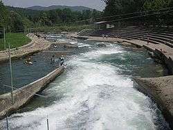
There are several sports and recreational grounds located on the river course or gravel pit and artificial lakes adjacent to the Sava. Tacen Whitewater Course, located on the right bank of the Sava in Tacen suburb of Ljubljana, was built as a permanent kayaking course in 1948.[134] It hosts a major international competition almost every year, examples being the ICF Canoe Slalom World Championships in 1955, 1991,[135] and 2010.[136] In Zagreb, Jarun complex of lakes along the river course offers a range of facilities for swimming, water sports and cycling.[137] The island of Ada Ciganlija in Belgrade is the major recreational zone of the city, gathering as much as 100,000 visitors daily in summer months.[138][139]
The Sava River is the site of several regattas. Those include the International Sava Tour rowing regatta taking place between Zagreb and Brčko,[140] and the Belgrade Regatta (sailing regatta).[141]
The river is also the site of the Šabac Swimming Marathon—an open water swimming competition, running on an 18.8-kilometre (11.7 mi) course between the village of Jarak and the city of Šabac in Serbia. The competition is held annually since 1970, and was included in FINA international calendar from 1984 to 2012.[142]
Recreational and sport fishing is a popular activity along the Sava River course.[102] There is a 700 metres (2,300 feet) long sport fishing competition ground near Hotemež, Slovenia.[143]
Tradition
Even though the name Sava became very common among Slavs (and not only among South Slavs), especially as a personal name (either male or female) and has a "Slavic tone", the river's name has pre-Slavic Celtic and Roman origins;[144] Strabo writes in Geographica 4.6.10 (composed between 20 BCE and 20 CE) of the River Saüs,[145] and the Romans used the name Savus. Another name, used for the Sava in entirety or its lower part by Strabo, is Noarus.[146]
Worship of various river gods in the area dates to the Late Bronze Age,[147] when the first settlements were founded along the Sava River.[148] Taurisci associated their river goddess Adsullata with the Savus.[144][147] Altars or inscriptions dedicated to the river-god Savus have been found at a number of locations along the river course, including at the Zelenci Pools where the Sava Dolinka rises, and a number of Roman settlements and castra built along the Via Pannonia, the Roman road running from Aquileia to the Danube.[149] The settlements include Emona, Andautonia and Siscia (near modern-day Ljubljana, Velika Gorica and Sisak respectively) upstream of the Kupa River confluence, and Marsonia, itself built atop a prehistoric settlement,[150] Cibalae, Sirmium and Singidunum (in modern-day Slavonski Brod, Vinkovci, Sremska Mitrovica and Belgrade) downstream of the Kupa.[151] Besides the altar found at the Zelenci Pools, inscriptions and sites dedicated to Savus have been found in remains of Emona,[152] Andautonia and Siscia.[153] Several years after 1751 completion of the Robba Fountain in Ljubljana, the three male figures sculpted as parts of the fountain were identified as statues of the river gods of Sava, Krka and Ljubljanica. In the early 20th century, the fountain was named the Fountain of Three Carniolan Rivers.[154]
The Romantic poet France Prešeren wrote The Baptism on the Savica (Slovene: Krst pri Savici), the Slovene national epic, in 1835. The poem, referring in its title to a headwater of the Sava River, helped to inspire the design of the coat of arms of Slovenia of 1991:
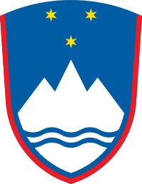
However, the two wavy lines at the base of the blazon officially represent rivers of Slovenia and the Adriatic Sea rather than the Savica or the Sava specifically.[155]
The Sava River also appears symbolically in the coat of arms of the former Kingdom of Slavonia:
.png)
The design, approved by the Vladislaus II of Bohemia and Hungary in 1496, incorporates two bars symbolising the Sava and the Drava rivers tracing the borders of the kingdom. The design inspired the arms of several present-day counties of Croatia in the region of Slavonia and itself forms a part of the coat of arms of Croatia.[156] The poem Horvatska domovina, written by Antun Mihanović in 1835 as a national symbol of Croatia, also refers to the Sava River. Modified lyrics of the poem later became the Croatian anthem.[157]
See also
Footnotes
- ↑ "Slovenski pravopis 2001: Sava".
- ↑ "Hrvatski jezični portal: Sava".
- ↑ Vrhovec, Pristov & Hočevar 1996, p. 123.
- 1 2 3 4 5 6 7 8 SURS 2002, p. 47.
- 1 2 Carey & Clark 2005, p. 50.
- 1 2 3 4 Tockner, Uehlinger & Robinson 2009, chapter 3.9.6..
- 1 2 Trišič et al. 1997, pp. 295–298.
- 1 2 ISRBC September 2009, p. 12.
- ↑ Orožen 1901, pp. 96.
- ↑ WFFC 2012.
- ↑ Fallon 2010, p. 133.
- ↑ McKelvie & McKelvie 2008, p. 111.
- ↑ Singleton 1985, p. 3.
- ↑ ISRBC September 2009, p. 113.
- ↑ Primožič, Kobold & Brilly 2008, p. 1.
- 1 2 3 4 ISRBC February 2009.
- ↑ ICPDR.
- ↑ Bostan et al. 2011, p. 127.
- ↑ Todorova 2009, p. 30.
- ↑ Promitzer, Hermanik & Staudinger 2009, p. 10.
- ↑ Lampe 2000, p. 13.
- ↑ & HSE (Moste).
- 1 2 ISRBC September 2009, p. 53.
- ↑ HSE (Mavčiče).
- ↑ HSE (Medvode).
- ↑ Municipality of Ljubljana.
- ↑ ECRR 2006, pp. 81–83.
- ↑ Municipality of Dol pri Ljubljani 2007.
- ↑ Municipality of Laško.
- ↑ HSE (Vrhovo).
- ↑ Krško NPP.
- ↑ ISRBC September 2009, p. 170.
- ↑ http://www.voda.hr/HV_PrikazVodostaja_EksternaVS8/A3.aspx?postajaID=5&slivID=1
- ↑ Google Earth
- ↑ Statistical Yearbook of the Republic of Croatia 2015, p. 49.
- ↑ Zagreb County Tourist Board.
- ↑ Aničić & Treer 1997, p. 162.
- ↑ Nacional 22 May 2006.
- ↑ Šterc 1979, p. 97.
- ↑ Index.hr 26 October 2011.
- ↑ ISRBC September 2009, p. 187.
- 1 2 ISRBC September 2009, pp. 160-161.
- ↑ Nova TV 4 January 2012.
- ↑ tportal.hr 7 July 2011.
- ↑ Index.hr 19 January 2011.
- ↑ ISRBC 2011, p. 37.
- ↑ Lonjsko Polje NP (a).
- ↑ Lonjsko Polje NP (b).
- ↑ Nadilo 2000, p. 183.
- ↑ ISRBC 2011, p. 69.
- ↑ ISRBC 2011, p. 103.
- ↑ JP Ada Ciganlija.
- ↑ ISRBC 2011, p. 109.
- ↑ ISRBC September 2009, p. 146.
- ↑ RZS 2011, p. 19.
- 1 2 3 4 Croatian Census 2011.
- ↑ Bašić 2005, pp. 63-64.
- ↑ SURS Census – Naselja 2002, p. L.
- ↑ SURS Census – Občine 2007.
- 1 2 CoM BiH 2003, p. 13.
- ↑ SURS Census – Naselja 2007, p. K.
- ↑ RZS 2011, p. 21.
- ↑ Municipality of Gradiška.
- ↑ RZS 2011, pp. 19, 21.
- ↑ SURS Census – Naselja 2007.
- ↑ HRT 2000.
- ↑ The Talon 22 March 1996, pp. 1, 12.
- ↑ ISRBC September 2009, pp. 5-8.
- ↑ ISRBC September 2009, p. 6.
- 1 2 ISRBC September 2009, pp. 12-13.
- ↑ ISRBC September 2009, pp. 13-14.
- ↑ Oikos 2008, p. 20.
- ↑ Mayer 1996, p. 31.
- ↑ Mayer 1996, p. 32.
- ↑ Tutiš 2014, p. 3.
- ↑ ISRBC November 2011 (a), p. 3.
- ↑ ISRBC November 2011 (a), pp. 5-6.
- 1 2 Placer 2008, p. 207.
- ↑ Placer 2008, p. 209.
- ↑ Bavec & Verbič 2001, p. 385.
- ↑ Stepišnik 2012, pp. 300–303.
- ↑ Placer 2008, p. 206.
- ↑ Topole 2003, p. 53.
- ↑ Topole 2003, p. 46.
- ↑ Kolar-Jurkovšek & Jurkovšek 2012, p. 324.
- ↑ Ramovš, Sremać & Kulenović 1987, p. 398.
- ↑ Placer 2008, p. 208.
- ↑ Haas 2012, pp. 14–18.
- ↑ Hilbers 2011, p. 16.
- ↑ Saftić et al. 2003, p. 108.
- ↑ Malvić & Velić 2011, p. 221.
- ↑ Hrvatske vode, section 2.1.
- ↑ Pamić, Radonić & Pavić 2003, p. 6.
- ↑ Bačani, Šparica & Velić 1999, p. 149.
- ↑ Vukovar-Syrmia County 2006, p. 6.
- 1 2 ISRBC December 2010, p. 25.
- ↑ ISRBC December 2010, p. 15.
- ↑ & HESS (Boštanj).
- ↑ Jalušić 2011, p. 9.
- ↑ Savske Elektrarne Ljubljana.
- ↑ HESS (Projekti).
- 1 2 Habeković, Homen & Fašaić 1990, p. 9.
- ↑ Habeković et al. 1997, p. 99.
- ↑ ISRBC History.
- 1 2 ISRBC Mission.
- ↑ ISRBC 2011, p. 27.
- 1 2 MMATI 2008, p. 19.
- ↑ UNECE 1996, p. 84.
- ↑ UNECE 1996, p. 16.
- ↑ BMG.
- ↑ MMATI 2008, p. 18.
- 1 2 Danube Strategy in Serbia.
- ↑ MMATI 2010, section 1.1.3..
- ↑ MMATI 2008, p. 35.
- ↑ Al Jazeera Balkans 22 April 2012.
- 1 2 MMATI 2008, p. 52.
- ↑ EU 9 September 2002.
- ↑ ECOSOC 2002, pp. 11-12.
- ↑ ECOSOC 2002, p. 17.
- ↑ Brnjac, Abramović & Maslarić 2010, p. 303.
- ↑ Orient-Express at Encyclopædia Britannica
- ↑ ISRBC Bridges 2011, p. 24.
- ↑ JANAF.
- ↑ ISRBC November 2011 (b), p. 38.
- 1 2 ISRBC November 2011 (b), p. 41.
- ↑ ISRBC November 2011 (b), p. 42.
- ↑ ISRBC November 2011 (b), p. 50.
- ↑ ISRBC November 2011 (b), p. 68.
- ↑ Vuković et al. 2011, p. 13.
- 1 2 ISRBC November 2011 (b), p. 66.
- ↑ Bošnir et al. 2003, p. 34.
- ↑ Vuković et al. 2011, p. 14.
- ↑ ISRBC December 2010, p. 13.
- ↑ Canoe Federation of Slovenia (a).
- ↑ Canoe Federation of Slovenia (b).
- ↑ Sinfo October 2010, p. 35.
- ↑ Zagreb Holding.
- ↑ Politika 14 July 2008.
- ↑ Press 2 July 2012.
- ↑ Vasić, Mandić & Nedeljkov 2011, p. 103.
- ↑ 24 sata 8 August 2011.
- ↑ Šabac Marathon 2013.
- ↑ Slovenian Tourist Board.
- 1 2 Šašel Kos 2009, p. 46.
- ↑ Strabo (1917–1932). Jones, H. L.; Thayer, Bill, eds. Geographica. Loeb Classical Library. Harvard University Press. Retrieved 2016-08-21.
After the Iapodes comes Segestica [Sisak], a city in the plain, past which flows the River Saüs, which empties into the Ister [Danube].
- ↑ Šašel Kos 2009, pp. 42-43.
- 1 2 Rendić-Miočević 2012, p. 300.
- ↑ Vasić, Mandić & Nedeljkov 2011, p. 78.
- ↑ Deluka, Dragčević & Rukavina 2003, p. 739.
- ↑ Buzov 2011, p. 367.
- ↑ Buzov 2011, p. 369.
- ↑ Šašel Kos 2009, p. 43.
- ↑ Rendić-Miočević 2012, p. 294.
- ↑ National Gallery of Slovenia.
- ↑ GCO June 2011, p. 9.
- ↑ Brunčić 2003, p. 44.
- ↑ MVPEI.
References
- Books
- Bavec, Miloš; Verbič, Tomaž (2001). "Glacial History of Slovenia". In Ehlers, J.; Gibbard, P.L.; Hughes, P.D. Quaternary Glaciations – Extent and Chronology: A Closer Look, Volume 4. Amsterdam, The Netherlands: Elsevier. ISBN 978-0-444-53447-7.
- Bostan, Ion; Gheorghe, Adrian V.; Dulgheru, Valeriu; Bostan, Viorel; Sochireanu, Anatol; Dicusară, Ion (2011). "Conversion of renewable kinetic energy of water: Synthesis, theoretical modeling, and experimental evaluation". In Adrian Gheorghe; Liviu Mureșan. Energy Security: International and Local Issues, Theoretical Perspectives, and Critical Energy Infrastructures. Berlin, Germany: Springer. ISBN 978-94-007-0718-4.
- Carey, Justi; Clark, Roy (2005). The Julian Alps of Slovenia. Milnthorpe, England: Cicerone Press Limited. ISBN 978-1-85284-438-7.
- Deluka, Aleksandra; Dragčević, Vesna; Rukavina, Tatjana (2003). "Roman roads in Croatia" (PDF). In Huerta Fernández, Santiago. Construction History: Proceedings of the First International Congress : Madrid 20th - 24th January 2003 (PDF). Madrid, Spain: Instituto Juan de Herrera. pp. 733–742. ISBN 978-84-9728-070-9.
- Fallon, Steve (2010). Slovenia. Melbourne, Australia: Lonely Planet. ISBN 978-1-74104-857-5.
- Haas, János (2012). "Geological and Tectonic Setting". In Lóczy, Dénes; Stankoviansky, Miloš; Kotarba, Adam. Recent Landform Evolution: The Carpatho-Balkan-Dinaric Region. New York City: Springer Publishing. ISBN 978-94-007-2447-1.
- Hilbers, Dirk (2011). The Nature Guide to the Hortobágy and Tisza River Floodplain, Hungary. Arnhem, The Netherlands: Crossbill Guides Foundation.
- Lampe, John R. (2000). Yugoslavia as History: Twice there was a Country. Cambridge, England: Cambridge University Press. ISBN 978-0-521-77401-7.
- Malvić, Tomislav; Velić, Josipa (2011). "Neogene Tectonics in Croatian Part of the Pannonian Basin and Reflectance in Hydrocarbon Accumulations" (PDF). In Schattner, Uri. New Frontiers in Tectonic Research - At the Midst of Plate Convergence (PDF). New York. pp. 215–238. ISBN 978-953-307-594-5.
- McKelvie, Robin; McKelvie, Jenny (2008). Slovenia: The Bradt Travel Guide. Chalfont St Peter, England: Bradt Travel Guides. ISBN 978-1-84162-211-8.
- Orožen, Fran (1901). Vojvodina Kranjska: Prirodoznanski, politični in kulturni opis [Duchy of Carniola: A natural-scientific, political and cultural description] (in Slovenian). Ljubljana, Slovenia: Slovenska matica. OCLC 27690684.
- Promitzer, Christian; Hermanik, Klaus-Jürgen; Staudinger, Eduard (2009). (Hidden) Minorities: Language and Ethnic Identity Between Central Europe and the Balkans. Münster, Germany: LIT Verlag. ISBN 978-3-643-50096-0.
- Ramovš, A.; Sremać, J.; Kulenović, E. (1987). "Results of biostratigraphical investigations in Western Yugoslav Paleozoic realized in IGCP Project No. 5". In Flügel, H.W.; Sassi, F.P.; Grecula, P. Pre-Variscan and Variscan Events in the Alpine-Mediterranean Mountain Belts (PDF). Bratislava, Czechoslovakia: Alfa Publishers. pp. 397–406. OCLC 18925979.
- Šašel Kos, Marjeta (2009). "Reka kot božanstvo – Sava v antiki" [River as a Deity – The Sava in Antiquity] (PDF). In Peternel, Jožef. Ukročena lepotica: Sava in njene zgodbe [The Tamed Beauty: The Sava and Its Stories] (PDF) (in Slovenian). Sevnica, Slovenia: Javni zavod za kulturo, šport, turizem in mladinske dejavnosti. pp. 42–50. ISBN 978-961-92735-0-0.
- Singleton, Frederick Bernard (1985). A Short History of the Yugoslav Peoples. Cambridge, England: Cambridge University Press. ISBN 978-0-521-27485-2.
- Stepišnik, Uroš (2012). "Glacial Geomorphology". In Lóczy, Dénes; Stankoviansky, Miloš; Kotarba, Adam. Recent Landform Evolution: The Carpatho-Balkan-Dinaric Region. New York City: Springer Publishing. ISBN 978-94-007-2447-1.
- Tockner, Klement; Uehlinger, Urs; Robinson, Christopher T. (2009). Rivers of Europe. Waltham, Massachusetts: Academic Press. ISBN 978-0-12-369449-2.
- Todorova, Maria (2009). Imagining the Balkans. Oxford, England: Oxford University Press. ISBN 978-0-19-538786-5.
- Topole, Maja (2003). Geografija občine Moravče [Geography of the Municipality of Moravče] (in Slovenian). Ljubljana, Slovenia: Založba ZRC. ISBN 978-961-6500-06-7.
- Trišič, Niko; Bat, Marjan; Polajnar, Janez; Pristov, Janko (1997). "Water balance investigations in the Bohinj region". In Kranjc, Andrej. Tracer Hydrology 97: Proceedings of the 7th International Symposium on Water Tracing, Portorož, Slovenia, 26–31 May 1997. London, England: Taylor & Francis. ISBN 978-90-5410-875-7.
- Vasić, Borislav; Mandić, Miodrag; Nedeljkov, Aleksandar (2011). Sava - Nautical and Tourist Guide (PDF). Zagreb, Croatia: Croatian Chamber of Commerce. ISBN 978-953-7622-18-3.
- Vrhovec, T.; Pristov, N.; Hočevar, A. (1996). "Air Pollution Deposition Variability in a Slovene Alpine Headwater as a Consequence of Topography and General Circulation Assessed by Theoretical Model". In Josef Křeček; G. S. Rajwar; Martin J. Haigh. Hydrological Problems and Environmental Management in Highlands and Headwaters: Updating the Proceedings of the First and Second International Conferences on Headwater Control. London, England: Taylor & Francis. ISBN 978-90-5410-726-2.
- Scientific and professional papers
- Aničić, B.; Treer, T. (December 1997). "Uređenje krajolika u ribarstvu" [Landscape architecture in fisheries]. Ribarstvo (in Croatian). University of Zagreb. 55 (4): 161–166. ISSN 1330-061X.
- Bačani, Andrea; Šparica, Marko; Velić, Josipa (December 1999). "Quaternary Deposits as the Hydrogeological System of Eastern Slavonia". Geologia Croatica. Croatian Geological Survey. 52 (2): 141–152. ISSN 1333-4875.
- Bašić, Ksenija (July 2005). "Apsolutna decentralizacija u populacijskom razvoju Zagrebačke aglomeracije" [Absolute Decentralization in Population Development of Zagreb Agglomeration]. Hrvatskigeografski glasnik (in Croatian). Croatian geographic society. 67 (1): 63–78. ISSN 1331-5854.
- Bošnir, Jasna; Puntarić, Dinko; Škes, Ivo; Klarić, Maja; Šimić, Spomenka; Zorić, Ivan; Galić, Radoslav (June 2003). "Toxic Metals in Freshwater Fish from the Zagreb Area as Indicators of Environmental Pollution". Collegium Antropologicum. Croatian Anthropological Society. 27 (1, Supplement 1): 31–39. ISSN 0350-6134.
- Brnjac, Nikolina; Abramović, Borna; Maslarić, Marinko (July 2010). "Forecasting Intermodal Transport Requirements on Corridor X". PROMET – Traffic&Transportation. University of Zagreb, Faculty of Transport and Traffic Engineering. 22 (4): 303–307. doi:10.7307/ptt.v22i4.195. ISSN 0353-5320.
- Buzov, Marija (October 2011). "Ancient Settlements along the Sava river". Histria antiqua. Institute of Social Sciences Ivo Pilar. 20 (20): 355–373. ISSN 1331-4270.
- Habeković, Dobrila; Homen, Zlatko; Fašaić, Krešo (March 1990). "Ihtiofauna dijela rijeke Save" [Ichthiofauna of a part of the Sava River]. Ribarstvo (in Croatian). University of Zagreb. 45 (1–2): 8–14. ISSN 1848-0586.
- Habeković, D.; Safner, R.; Aničić, I.; Treer, T. (October 1997). "Ihtiofauna dijela rijeke Save" [Ichthiofauna of a part of the Sava River]. Ribarstvo (in Croatian). University of Zagreb. 55 (3): 99–110. ISSN 1848-0586.
- Jalušić, Tatjana (May 2011). "Slovenija gradi, Hrvatska priprema izgradnju" [Slovenia builds, Croatia prepares to build] (PDF) (in Croatian). 25 (244/284). Hrvatska elektroprivreda: 9. ISSN 1332-5310.
- Kolar-Jurkovšek, Tea; Jurkovšek, Bogdan (2012). "Late Carboniferous floras of Slovenia – a review". Geologia Croatica. Croatian Geological Survey. 65 (3): 323–328. ISSN 1333-4875.
- Mayer, Darko (December 1996). "Zalihe pitkih voda u Republici Hrvatskoj" [Potable water reserves in the Republic of Croatia]. Rudarsko-geološko-naftni zbornik (in Croatian). University of Zagreb. 8 (1): 27–35. ISSN 0353-4529.
- Nadilo, Branko (2000). "Obnova graničnih mostova na Savi" [Reconstruction of border bridges on Sava] (PDF). Građevinar (in Croatian). Croatian Association of Civil Engineers. 52 (3): 181–185. ISSN 0350-2465.
- Pamić, Jakob; Radonić, Goran; Pavić, Goran (2003). "Geološki vodič kroz park prirode Papuk" [Geological guide to the Papuk Nature Park] (PDF) (in Croatian). Papuk Geopark.
- Placer, Ladislav (2008). "Principles of the tectonic subdivision of Slovenia". Geologija. Geološki zavod Ljubljana in Slovensko geološko društvo. 51 (2): 205–217. doi:10.5474/geologija.2008.021. ISSN 0016-7789.
- Primožič, Miha; Kobold, Mira; Brilly, Mitja (2008). "The implementation of the HBV model on the Sava River basin" (PDF). IOP Conf. Series: Earth and Environmental Science. IOP Publishing. 4. doi:10.1088/1755-1307/4/1/012004. ISSN 1755-1315.
- Rendić-Miočević, Ante (August 2012). "Rivers and River Deities in Roman Period in the Croatian Part of Pannonnia". Histria antiqua. Institute of Social Sciences Ivo Pilar. 21 (21): 293–306. ISSN 1331-4270.
- Saftić, Bruno; Velić, Josipa; Sztanó, Orsolya; Juhász, Györgyi; Ivković, Željko (June 2003). "Tertiary Subsurface Facies, Source Rocks and Hydrocarbon Reservoirs in the SW Part of the Pannonian Basin (Northern Croatia and South-Western Hungary)". Geologia Croatica. Croatian Geological Survey. 56 (1): 101–122. ISSN 1333-4875.
- Šterc, Stjepan (June 1979). "Kanal Sava – Odra -Sava kao objekt obrane Zagreba od poplava" [Sava – Odra – Sava canal as floodwater protection structure of the city of Zagreb]. Hrvatski geografski glasnik (in Croatian). Croatian Geographic Society. 41–42 (1): 95–117. ISSN 1331-5854.
- Vuković, Živorad; Marković, Ljiljana; Radenković, Mirjana; Vuković, Dubravka; Stanković, Srboljub (March 2011). "Heavy Metal and Bacterial Pollution of the Sava River in Serbia". Archives of Industrial Hygiene and Toxicology. Institute for Medical Research and Occupational Health, Zagreb. 62 (1): 11–15. doi:10.2478/10004-1254-62-2011-2051. ISSN 0004-1254.
- News reports
- "Avionska bomba u Savi ispod Savskog mosta Gunja - Brčko" [An aircraft Bomb found in Sava under the Gunja - Brčko Bridge] (in Croatian). Nova TV (Croatia). 4 January 2012.
- Mario Duspara (22 May 2006). "Obiteljski park na južnoj obali Save" [Family park at the south bank of Sava]. Nacional (weekly) (in Croatian). Archived from the original on 7 July 2012.
- Janjušević, Zorica (2 July 2012). "Na Adi 100.000 ljudi" [100,000 People at Ada]. Press (in Serbian).
- Lee, Jack (22 March 1996). "Engineers rebuild Brcko Road bridge" (PDF). The Talon. 1st Armored Division (United States).
- "NATO-ove bombe još uvijek prijete Srbiji" [NATO bombs still threaten Serbia] (in Croatian). Index.hr. 19 January 2011.
- Nikolić, M. (8 August 2011). "Beogradska regata 14. avgusta" [Belgrade Regatta on 14 August] (in Serbian). 24 sata (Serbia).
- "Otvoren obnovljeni most Gunja-Brčko" [Reconstructed Gunja-Brčko bridge reopened] (in Croatian). Croatian Radiotelevision. 25 October 2000.
- Perović, Ljiljana (14 July 2008). "Sto hiljada sugrađana na Vodenom cvetu" [One Hundred Thousand Citizens at the Water Flower] (in Serbian). Politika.
- "Prije točno 47 godina katastrofalna poplava ubila je 17 ljudi i uništila veliki dio Zagreba" [Exactly 47 years ago, a catastrophic flood kills 17 and destroys a large part of Zagreb] (in Croatian). Index.hr. 26 October 2011.
- Rapaić, Sanja (7 July 2011). "Bombe i minobacačke granate u slavonskim rijekama" [Bombs and mortar rounds in Slavonia's rivers]. t-portal (in Croatian).
- Švab, Matic (October 2010). "2010 ICF Canoe Slalom World Championships SLOKA 2010" (PDF).
- "Šansa regionalnog razvoja riječnog prometa" [A chance for regional development of river transport] (in Bosnian). Al Jazeera Balkans. 22 April 2012.
- Other sources
- "2011 Census of Population, Households and Dwellings in the Republic of Serbia – First Results" (PDF). Belgrade, Serbia: Statistical Office of the Republic of Serbia. 2011.
- "About Basin". International Sava River Basin Commission. 5 February 2009.
- "Ada Ciganlija" [Ada Ciganlija] (in Serbian). JP Ada Ciganlija.
- "Album of bridges on the Sava River and its navigable tributaries" (PDF). International Sava River Basin Commission. 2011.
- "Analiza sliva rijeke Save – Sažetak" [Sava River basin analysis – Summary] (PDF) (in Bosnian). International Sava River Basin Commission. December 2010.
- Andričević, Roko (2011). "Pilot Project on Climate Change Adaptation Building the Link between Flood Risk Management Planning and Climate Change Assessment in the Sava River Basin" (PDF). United Nations Economic Commission for Europe.
- "Background paper No.2: Groundwater bodies in the Sava River Basin, v2.0" (PDF). Zagreb: International Sava River Basin Commission. November 2011.
- "Background paper No.3: Significant pressures identified in the Sava River Basin, v3.0" (PDF). Zagreb: International Sava River Basin Commission. November 2011.
- "Bird reserve". Zagreb County Tourist Board.
- Brunčić, Davor (2003). "The Symbols of Osijek-Baranja County" (PDF). Osijek-Baranja County.
- "Демографија" [Demographics] (in Serbian). Municipality of Gradiška.
- "European Agreement on Main Inland Waterways of International Importance (AGN)" (PDF). United Nations Economic Commission for Europe. 19 January 1996. Retrieved 21 October 2012.
- "European Agreement on Main International Traffic Arteries (AGR) - Consolidated text of the AGR" (PDF). United Nations Economic and Social Council. 5 April 2002.
- "Fishing on Sava river". Slovenian Tourist Board.
- "HE Boštanj" [Boštanj HPP] (in Slovenian). Hidroelektrarne na Spodnji Savi, d.o.o.
- "HE Mavčiče" [Mavčiče Hydroelectric Power Plant] (in Slovenian). Holding Slovenske elektrarne.
- "HE Medvode" [Medvode Hydroelectric Power Plant] (in Slovenian). Holding Slovenske elektrarne.
- "HE Moste" [Moste Hydroelectric Power Plant] (in Slovenian). Holding Slovenske elektrarne.
- "HE Vrhovo" [Vrhovo Hydroelectric Power Plant] (in Slovenian). Holding Slovenske elektrarne.
- "Hidroelektrarne na Savi" [Hydroelectric power plants on the Sava] (in Slovenian). Savske Elektrarne Ljubljana.
- "History". International Sava River Basin Commission. 12 December 2008.
- "History of Sabac Marathon". Šabac Marathon. August 2012.
- "Indicator of river kilometres for the Sava River and its navigable tributaries" (PDF). Zagreb: International Sava River Basin Commission. 2011.
- "Izviješće o stanju okoliša Vukovarsko-srijemske županije" [Report on environmental conditions in the Vukovar-Syrmia County] (PDF). Službeni glasnik Vukovarsko-srijemske županije (in Croatian). Vukovar-Syrmia County. 14 (18). 27 December 2006. ISSN 1846-0925.
- "Izvještaj Bosne i Hercegovine o zakonodavnim i drugim mjerama na provođenju načela utvrđenih u okvirnoj konvenciji za zaštitu nacionalnih manjina" [Report of Bosnia and Herzegovina on legislative and other measures regarding implementation of principles determined by framework convention on protection of national minorities] (PDF) (in Bosnian). Sarajevo: Council of Ministers of Bosnia and Herzegovina. December 2003.
- "Lonjsko Polje Nature Park Map". Lonjsko Polje Nature Park.
- "State emblems". Ministry of Foreign and European Affairs (Croatia).
- "O Parku" [About the park] (in Croatian). Lonjsko Polje Nature Park.
- "Okoljsko poročilo za pripravo obcinskega lokacijskega nacrta za obmocje urejanja PD 12/1 Jeprca" [Environmental Report for Preparation of Municipal Physical Plan of the PD 12/1 Jeprca Development Area] (PDF) (in Slovenian). Medvode Municipality. May 2008.
- Ostroški, Ljiljana, ed. (December 2015). "Geographical and Meteorological Data". Statistički ljetopis Republike Hrvatske 2015 [Statistical Yearbook of the Republic of Croatia 2015] (PDF). Statistical Yearbook of the Republic of Croatia (in Croatian and English). 47. Zagreb: Croatian Bureau of Statistics. ISSN 1333-3305. Retrieved 27 December 2015.
- "Luke i pristaništa" [Ports and harbours] (in Serbian). Danube Strategy in Serbia.
- "Mission". International Sava River Basin Commission. 12 December 2008.
- "Plan upravljanja vodnim područjima – Dodatak I. Analiza značajki Vodnog područja rijeke Dunav" [Water management plan - Annex 1 - Analysis of the Danube River area properties] (PDF) (in Croatian). Hrvatske vode.
- "Plant systems and operation". Krško Nuclear Power Plant.
- "Prebivalstvo po starostnih skupinah in spolu – skupaj, naselja, Slovenija, popis 2002" [Population by Age Groups and Sex – Total, Settlements, Slovenia 2002 Census] (in Slovenian). Statistical Office of the Republic of Slovenia. 2002.
- "Prebivalstvo po starostnih skupinah in spolu – skupaj, naselja, Slovenija, popis 2002, preračun na občine, veljavne dne 1. 1. 2007" [Population by Age Groups and Sex, Slovenia, 2002 Census, Recalculated by Municipalities in Place on 1 January 2007] (in Slovenian). Statistical Office of the Republic of Slovenia. 2007.
- "Population by Age and Sex, by Settlements, 2011 Census". Census of Population, Households and Dwellings 2011. Zagreb: Croatian Bureau of Statistics. December 2012.
- "Površinske vode" [Surface waters] (in Slovenian). Municipality of Ljubljana.
- "Presentation of the municipality". Dol pri Ljubljani Municipality. 15 December 2007.
- "Projekti" [Projects] (in Slovenian). Hidroelektrarne na spodnji Savi.
- "River Sava Bohinjka (Sector I)". Fishing Association of Slovenia.
- "Territory and climate" (PDF). Statistical Yearbook of the Republic of Slovenia. Statistical Office of the Republic of Slovenia (41). Rivers, longer than 25 km, and their catchment areas. 2002. ISSN 1318-5403.
- "RŠC Jarun" [Recreational and Sports Centre Jarun] (in Croatian). Zagreb Holding.
- "Sava" [Sava] (in Bosnian). BMG Bosanska medijska grupa.
- "Sava River Basin Analysis Report" (PDF). Zagreb, Croatia: International Sava River Basin Commission. September 2009.
- "Slovenian Symbols" (PDF). Government Communication Office (Slovenia). June 2011.
- "Srednjoročni plan razvitka vodnih putova i luka unutarnjih voda Republike Hrvatske (za razdoblje 2009.-2016. godine)" [Mid-term plan of development of internal waterways and internal waterway ports in the Republic of Croatian (for 2009–2016 period)] (PDF) (in Croatian). Ministry of Maritime Affairs, Transport and Infrastructure (Croatia). December 2008.
- "Strateški plan Ministarstva mora, prometa i infrastrukture za razdoblje 2011.-2013." [Strategic plan of the Ministry of Maritime Affairs, Transport and Infrastructure for period of 2011–2013] (in Croatian). Ministry of Maritime Affairs, Transport and Infrastructure (Croatia). 6 August 2010.
- "Tacen". Canoe Federation of Slovenia.
- "Tacenska kajakaška proga" [Tacen Kayaking Course] (in Slovenian). Canoe Federation of Slovenia.
- "The JANAF system". Jadranski naftovod.
- "The Robba Fountain". National Gallery of Slovenia.
- "Tisza Basin – the largest sub-basin of the Danube". International Commission for the Protection of the Danube River.
- "Transport: launch of the Italy-Turkey pan-European Corridor through Albania, Bulgaria, Former Yugoslav Republic of Macedonia and Greece". European Union. 9 September 2002.
- "WFD and hydromorphological pressures – Technical report – Case studies" (PDF). European Centre for River Restoration. November 2006.
- "Zgodovina" [Town history] (in Slovenian). Municipality of Laško.
- "Velike vode donjeg toka rijeke Save tijekom svibnja 2014." [High Waters of Sava River Lover Course in May 2014]. Hydrometeorological State Institute of Croatia.
External links
| Wikimedia Commons has media related to Sava. |
| Wikisource has the text of the 1911 Encyclopædia Britannica article Save. |
- Condition of Sava at locations in Slovenia (proceeding from the upper to the lower stream):
- Radovljica – graphs, in the following order, of water level, flow and temperature data for the past 30 days (taken in Radovljica by ARSO)
- Medno – graphs, in the following order, of water level, flow and temperature data for the past 30 days (taken in Medno by ARSO)
- Šentjakob – graphs, in the following order, of water level, flow and temperature data for the past 30 days (taken in Šentjakob by ARSO)
- Hrastnik – graphs, in the following order, of water level, flow and temperature data for the past 30 days (taken in Hrastnik by ARSO)
- Jesenice na Dolenjskem – graphs, in the following order, of water level and temperature data for the past 30 days (taken in Jesenice na Dolenjskem by ARSO)
Hydrography of Slovenia | ||
|---|---|---|
| Rivers |
|  |
| Streams | ||
| Waterfalls | ||
| Lakes | ||
| Wetlands | ||
| Sea | ||
| River valleys |
| |
| Canyons and gorges |
| |

| Countries | 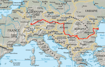 | |
|---|---|---|
| Cities | ||
| Tributaries | ||
| See also | ||