Bristol, Texas
| Bristol, Texas | |
|---|---|
| census-designated place | |
 Bristol | |
| Coordinates: 32°27′18″N 96°34′02″W / 32.45500°N 96.56722°WCoordinates: 32°27′18″N 96°34′02″W / 32.45500°N 96.56722°W | |
| Country |
|
| State |
|
| County | Ellis |
| Area[1] | |
| • Total | 5.88 sq mi (15.2 km2) |
| • Land | 5.78 sq mi (15.0 km2) |
| • Water | 0.10 sq mi (0.3 km2) |
| Elevation | 486 ft (148 m) |
| Population (2010) | |
| • Total | 668 |
| • Density | 110/sq mi (44/km2) |
| Time zone | Central (UTC-6) |
| • Summer (DST) | Central (UTC-5) |
| ZIP code | 75119 |
| Area code(s) | 972 |
| GNIS feature ID | 2586912[2] |
Bristol is a census-designated place in Ellis County, Texas, United States. The population was 668 at the 2010 census.[3]
Geography
Bristol is located along Farm to Market Road 660 in northeastern Ellis County, approximately six miles northeast of Palmer and eighteen miles northeast of Waxahachie.[4] It is part of the Dallas–Fort Worth metroplex.
According to the United States Census Bureau, the CDP has a total area of 5.88 square miles (15.2 km2), of which 5.78 square miles (15.0 km2) is land and 0.10 square miles (0.26 km2) is water.[5]
History
Settlement of the area dates back to the 1840s. The community was first called Brockville and a post office operated under that name from 1854 to 1869. Later, the community was unofficially known as Heelstring.[4]
Years later, Captain Steven Mills came to the area and opened a store. Having done business in Bristol, England, he named the store Bristol and the community eventually adopted the name.[6] By 1890, Bristol had grown into a farming community of approximately 200 residents. The population peaked at around 300 in the early 1930s and declined thereafter. The community continues to serve as a supply and service center for area farmers.[6]
In 2010, Bristol was defined as a census-designated place (CDP) by the U.S. Census Bureau. The boundaries include the original community of Bristol and surrounding areas.
Demographics
At the 2010 United States Census[7] there were 668 people, 239 households, and 188 families residing in the CDP. The racial makeup of the city was 91.2% White (81.4% Non-Hispanic White), 0.4% Native American, 2.8% African American, 0.1% Asian, 4.8% from other races, and 0.6% from two or more races. Hispanic or Latino of any race were 14.8% of the population.
Education
The Ennis Independent School District, Ferris Independent School District, and Palmer Independent School District each serve portions of the Bristol area.
References
- ↑ U.S. Census Archived 2012-01-24 at WebCite
- ↑ U.S. Geological Survey Geographic Names Information System: Bristol, Texas
- ↑ "Profile of General Population and Housing Characteristics: 2010 Demographic Profile Data (DP-1): Bristol CDP, Texas". U.S. Census Bureau, American Factfinder. Archived from the original on September 11, 2013. Retrieved January 9, 2016.
- 1 2 "Bristol, Texas". The Handbook of Texas online. Retrieved January 9, 2016.
- ↑ "Geographic Identifiers: 2010 Demographic Profile Data (G001): Bristol CDP, Texas". U.S. Census Bureau, American Factfinder. Archived from the original on September 11, 2013. Retrieved January 9, 2016.
- 1 2 "Bristol". Ellis County TXGenWeb. Retrieved January 9, 2016.
- ↑ U.S. Census Bureau. Retrieved January 9, 2016.
Municipalities and communities of Ellis County, Texas, United States | ||
|---|---|---|
| Cities | 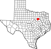 | |
| Towns | ||
| CDP | ||
| Unincorporated communities | ||
| Footnotes | ‡This populated place also has portions in an adjacent county or counties | |