British Columbia Highway 17
| ||||
|---|---|---|---|---|
|
Patricia Bay Highway (Vancouver Island section) South Fraser Perimeter Road (Mainland section) | ||||
|
Highway 17 highlighted in red, upper left insert shows Highway 17 on Vancouver Island. | ||||
| Route information | ||||
| Existed: | 1960 – present | |||
| Vancouver Island section | ||||
| Length: | 31 km (19 mi) | |||
| South end: |
| |||
| North end: | BC Ferries terminal at Swartz Bay | |||
| Lower Mainland section | ||||
| Length: | 44 km (27 mi) | |||
| West end: | BC Ferries terminal at Tsawwassen | |||
| Major junctions: |
| |||
| East end: |
| |||
| Location | ||||
| Major cities: | Victoria, Saanich, Delta (as a municipality), Surrey | |||
| Highway system | ||||
|
British Columbia provincial highways
| ||||

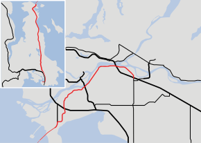
Highway 17 is a system of two separate highways: One on Vancouver Island, the other on the Lower Mainland, connected by a ferry link.
Route description
Vancouver Island section
The Island section of Highway 17 is known as the Patricia Bay Highway (locally abbreviated as the Pat Bay Highway) after nearby Patricia Bay, and is the main artery through the Saanich Peninsula, mostly travelling along its eastern coast. The highway is four lanes all the way from Victoria to Swartz Bay. The total length of the highway on the Island is 31 kilometres (19 mi). Highway 17 has had its present course through the area since 1978 when the Blanshard extension was completed.[1]
In the south, Highway 17 begins at the intersection of Belleville and Oswego streets one block to the west of the British Columbia Parliament Buildings.
From Douglas and Blanshard, the highway travels north as Blanshard Street (a six lane divided city street) for 3 km (1.9 mi) through the city of Victoria before leaving the city at Tolmie Avenue and for another 2 km (1.24 mi) north through the city of Saanich to the Uptown Shopping Centre; Highway 17 then becomes the Pat Bay Highway and turns into a 6 km (3.7 mi)-long freeway, with three interchanges. After the third interchange at Royal Oak Drive, Highway 17 turns into a 14 km (8.7 mi) mix of divided four-lane arterial and expressway including an interchange at McTavish Road, until it reaches the town of Sidney. After exiting Sidney 3 km (1.9 mi) later, the Pat Bay once again becomes a freeway, with two more interchanges along its length, toward its northern terminus at the Swartz Bay ferry terminal another 3 km (1.9 mi) north.
Ferry route
At Swartz Bay, Highway 17 leaves Vancouver Island, and starts on a 44 km (24 nmi)-long ferry route through the Southern Gulf Islands and the Strait of Georgia. The ferry route between Swartz Bay and the Mainland is the oldest and most heavily used route in the B.C. Ferries system. After winding through the Gulf Islands, the route enters a small passage between Galiano and Mayne Islands, known as Active Pass. Active Pass is the midway point on the Highway 17 ferry route, but it is also the most hazardous part, as it has strong tidal currents, and has historically been the site of two maritime collisions involving BC Ferries vessels, as well as one incident of a ferry running aground. Consequently, ferries going through Active Pass have to sound their whistles upon entering and leaving the passage, and must adhere to a lower speed limit while transiting through it.
After Active Pass, the Highway 17 ferry heads due northeast across the Strait of Georgia. Halfway across the Strait, the route begins transiting United States waters for just under 9 km (5 nmi). It then crosses the 49th parallel back into Canadian waters just before landing at the Tsawwassen Ferry Terminal.
Mainland section
On the Mainland, Highway 17 is known as the South Fraser Perimeter Road (SFPR), a component of the British Columbia Ministry of Transportation's Gateway Program. It is a four-lane expressway with a speed limit of 80 km/h (50 mph) over most of its length, connecting the Tsawwassen Ferry Terminal and Highway 99 in Delta to Highway 1 at 176th Street in Surrey, and providing access to all five of the major Fraser River crossings in Metro Vancouver.[2] The mainland section is notable for its extensive use of noise walls, split level construction through Delta and use in some urban sections of so-called Quiet Pavement to reduce traffic noise.[3]
The South Fraser Perimeter Road is 44 kilometres (27 mi) long. Beginning at the Tsawwassen Ferry Terminal, it heads northeast on a 1.8-kilometre (1.1 mi) long causeway to land on the Tsawwassen Peninsula, then continues northeast for 5 kilometres (3.1 mi) to its junction with Highway 17A. It then follows the CN Railway's Deltaport chord and 72nd Street northeast for 6.2 kilometres (3.9 mi) to an interchange with Highway 99. The road then runs through the west side of Burns Bog, but avoiding the conservation area, and past the south side of the Tilbury and Sunbury industrial areas for 9.7 kilometres (6.0 mi) before it reaches the Fraser River at a junction connecting to Highway 91. It then proceeds east along the south bank of the Fraser River through North Delta and Surrey, passing under the Alex Fraser, Pattullo and Port Mann bridges, before turning southeast at Surrey Bend Park to terminate at its junction with Highways 1 and 15, 21 kilometres (13 mi) from the access to Highway 91.
History
The South Fraser Perimeter Road (SFPR)
Route 17 once followed what is now Route 17A and River Road to get to Route 1 and Golden Ears Way. The provincial government proposed to build a new expressway, the South Fraser Perimeter Road, linking the Tsawwassen Ferry Terminal with the Trans-Canada Highway. According to the Ministry of Transportation the South Fraser Perimeter Road will improve the movement of goods and people across the region while also alleviating truck traffic on municipal roads. West/east travel times across the region will also be significantly reduced.[4]
The South Fraser Perimeter Road project was opposed by a number of groups, citing a variety of concerns. The SFPR alignment does not go through the Burns Bog Ecological Conservancy Area.[5] However, the Burns Bog Conservation Society has stated they are concerned that it will affect surrounding hydrology, and have an adverse effect on the Conservancy Area.[6]
The Burns Bog Conservation Society expressed concerns that the South Fraser Perimeter Road would endanger Burns Bog.[7] In response to the mitigation measures proposed the Environmental Stewardship Branch of Environment Canada wrote that "...that the changes are not sufficient to alleviate its concerns related to the impacts of the Project on Pacific Water Shrew (PWS), hydrology, aerial deposition, and ecological integrity of Burns Bog."[8] On November 24, 2010 the Burns Bog Conservation Society launched a lawsuit intend to force the re-routing or cancellation of the SFPR project.[9] Burns Bog has been listed as threatened by the International Mire Conservation Group because of the impacts of the SFPR.[10]
The Wilderness Committee and other groups have criticized the SFPR, and the Gateway Program in general, for increasing greenhouse gas emissions.[11] In early 2011, a protest camp organized by StopThePave.org and the Council of Canadians occupied a SFPR construction site for almost two weeks.[12]
The SFPR Project worked with the Burns Bog Scientific Advisory Panel to develop systems, which helped improve the existing drainage / hydrology of the bog.
A 10 km (6.2 mi) -long portion from 136 Street in Surrey to a junction with Highway 15 and Highway 1 was the first portion of the SFPR to be completed, opening on December 1, 2012. The remaining western segment of the road was completed on December 21, 2013.[13] The former Mainland portion of Highway 17 north of the 28th Avenue overpass has been renamed to Highway 17A through Ladner.[3] The total cost of building the SFPR was $1.26 billion.[14]
Future
On Vancouver Island, there have been numerous studies to upgrade the Island portion of Highway 17 to freeway standard. This seems to be edging closer with the BC Government's issuing of the Highway 17 Corridor Planning Strategy. This study envisions interchanges at Haliburton, Sayward, Keating Cross Road and/or Island View, Mt Newton Cross Road, McTavish Road (Complete April 9, 2011) and Beacon Avenue in Sidney.
On April 9, 2011 a new interchange at McTavish Road was opened with two multi-lane roundabouts at the end of the off-ramps. This interchange serves Victoria International Airport.[15]
In the Lower Mainland, the intersection at 104th Avenue in Surrey will eventually also be co-located with the Golden Ears Way Connector (to be constructed) which will provide direct access to Golden Ears Way and the Golden Ears Bridge from Highway 17.
Exit list
Leaving the Victoria city boundary, all of Highway 17 is a four-lane highway—large stretches of it being a freeway. Many of its exits are in fact numbered, including some of the at-grade traffic light intersections, which is also the case for all of the signalized intersections on the Nanaimo Parkway and the Inland Island Highway. While Highway 17 technically starts where Douglas Street meets Superior and Southgate Streets, its exit numbers are determined using distances from the intersection of Douglas Street and Dallas Road in Victoria.
All of the Mainland section is considered an expressway.
| Regional district | Location | km[16] | mi | Exit | Destinations | Notes | |
|---|---|---|---|---|---|---|---|
| Continues south as the arterial Blanshard Street into Downtown Victoria | |||||||
| Capital | District of Saanich | 2.2 | 1.4 | 7 | McKenzie Avenue | Interchange | |
| 4.1 | 2.5 | 8 | Vanalman Avenue | Southbound exit and entrance | |||
| 4.5 | 2.8 | 9 | Quadra Street east, West Saanich Road | Interchange; No southbound access to westbound West Saanich Road | |||
| 5.7 | 3.5 | 11 | Royal Oak Drive to Brentwood Bay | Interchange | |||
| 7.8 | 4.8 | (13) | Haliburton Road | At-grade | |||
| 8.3 | 5.2 | Claremont Avenue east | At-grade | ||||
| 8.7 | 5.4 | Piedmont Drive | Northbound exit and entrance | ||||
| 9.7 | 6.0 | (14) | Cordova Bay Road east | At-grade | |||
| 10.5 | 6.5 | 15 | Sayward Road | At-grade | |||
| 10.9 | 6.8 | Wells Road east | Northbound exit and entrance | ||||
| 11.2 | 7.0 | (16) | Old East Saanich Road east | At-grade | |||
| District of Central Saanich | 12.3 | 7.6 | (17) | Tanner Road | At-grade | ||
| 12.6 | 7.8 | Gliddon Road west | Northbound exit and entrance | ||||
| 12.7 | 7.9 | Rey Road west | Southbound exit and entrance | ||||
| 13.2 | 8.2 | Martindale Road east | Northbound exit and entrance | ||||
| 13.5 | 8.4 | 18 | Keating Cross Road west | At-grade, northbound exit and southbound entrance only | |||
| 13.7 | 8.5 | East Saanich Road west | At-grade, northbound exit only | ||||
| 13.8 | 8.6 | Danica Place east | Northbound exit and entrance | ||||
| 14.4 | 8.9 | 19 | Island View Road | At-grade | |||
| 15.6 | 9.7 | (20) | Jus Kun Road | Northbound exit only | |||
| 16.9 | 10.5 | 21 | Mt. Newton Cross Road | At-grade | |||
| District of North Saanich | 19.4 | 12.1 | (24) | Amity Drive | Partial access (right-in/right-out) | ||
| 20.9 | 13.0 | 26 | McTavish Road | Interchange; Access to Victoria Airport | |||
| Town of Sidney | 22.5 | 14.0 | (27) | Weiler Avenue West | Southbound exit only | ||
| 23.4 | 14.5 | 28 | Beacon Avenue | At-grade | |||
| 25.1 | 15.6 | (30) | McDonald Park Road | At-grade | |||
| District of North Saanich | 26.9 | 16.7 | 31 | McDonald Park Road, Wain Road to Brentwood Bay | Interchange | ||
| 28.1 | 17.5 | 33 | Lands End Road | Interchange; Northbound exit, southbound entrance only | |||
| 28.4 | 17.6 | Swartz Bay Ferry Terminal | |||||
| Strait of Georgia | |||||||
| Metro Vancouver | Municipality of Delta | 2.7 | 1.7 | 3 | Tsawwassen Drive | At-grade | |
| 3.5 | 2.2 | Salish Sea Drive | At-grade | ||||
| 4.3 | 2.7 | 4 | 52 Street | At-grade | |||
| 5.3 | 3.3 | 5 | 56 Street | At-grade | |||
| 6.9 | 4.3 | 7 | Eastbound-only | ||||
| 8.0 | 5.0 | 8 | Deltaport Way | Westbound-only | |||
| 13.1 | 8.1 | 13 | Interchange - No direct access from Highway 17 westbound to Highway 99 southbound; traffic from Highway 17 westbound to US border uses Highway 91 | ||||
| 19.3 | 12.0 | Tilbury Connector | At-grade | ||||
| 22.8 | 14.2 | At-grade | |||||
| City of Surrey | 27.2 | 16.9 | Elevator Road | Partial access (right-in/right-out) | |||
| 29.2 | 18.1 | 103A Avenue | Partial access (right-in/right-out) | ||||
| 29.7 | 18.5 | 31/32 | Tannery Road | Interchange | |||
| 30.4 | 18.9 | Old Yale Road | At-grade | ||||
| 31.7 | 19.7 | 33 | 124th Street | Partial access (right-in/right-out) | |||
| 33.0 | 20.5 | Bridgeview Drive, to | At-grade | ||||
| 42.9 | 26.7 | 104th Avenue, Golden Ears Way Connector to Pitt Meadows & Maple Ridge (via Golden Ears Bridge) | At-grade | ||||
| 44.1 | 27.4 | Interchange | |||||
| Continues as Highway 15 south through Surrey | |||||||
| 1.000 mi = 1.609 km; 1.000 km = 0.621 mi Exits in parentheses are not officially numbered. | |||||||
References
- ↑ https://books.google.ca/books?id=GO5eziadjjcC&pg=PA156&lpg=PA156&dq=blanshard+extension&source=bl&ots=-Ck_2Vu3nA&sig=sa2TC30Y07WpTDuzJeYRyZTnyIg&hl=en&sa=X&ved=0ahUKEwjCvuSe1d7LAhUG92MKHaI1Bb0Q6AEINTAE#v=onepage&q=blanshard%20extension&f=true
- ↑ "Gatewayprogram.bc.ca". Gatewayprogram.bc.ca. Retrieved November 29, 2012.
- 1 2 Sinoski, Kelly (November 30, 2012). "First 10 kilometres of new Highway 17 opens Dec. 1". The Vancouver Sun. Retrieved December 29, 2013.
- ↑ "TH.gov.bc.ca". TH.gov.bc.ca. Retrieved November 29, 2012.
- ↑ "TH.gov.bc.ca" (PDF). Archived from the original (PDF) on February 7, 2012. Retrieved November 29, 2012.
- ↑ Burnsbog.org, Burns Bog Conservation Society " Resources " Sustainable Development Strategy
- ↑ "Submission to Environmental Assessment Office". Burns Bog Conservation Society.
- ↑ Burnsbog.org
- ↑ Burns Bog Conservation Society. "LAWSUIT LAUNCHED OVER ROAD CONSTRUCTION ON BURNS BOG" (PDF). Archived from the original (PDF) on March 31, 2012. Retrieved September 1, 2011.
- ↑ International Mire Conservation Group. "Threatened Peatlands". Retrieved May 15, 2013.
- ↑ Wilderness Committee. "Gateway to Global Warming". Archived from the original on September 29, 2011. Retrieved September 1, 2011.
- ↑ Dawn, Paley (May 5, 2011). "Camp Closed, But Resistance Continues". Vancouver Media Co-op. Retrieved September 1, 2011.
- ↑ "South Fraser Perimeter Road, B.C.'s newest highway opens". Province of British Columbia. Retrieved December 22, 2013.
- ↑ "South Fraser Perimeter Road completed, officially opens today". Canada Newswire. December 21, 2013. Retrieved December 22, 2013.
- ↑ Ministry of Transportation and Infrastructure,Government of Canada (April 7, 2009). "Canada-Bc Partnership To Build Interchange". .news.gov.bc.ca. Retrieved December 29, 2013.
- ↑ "B.C. Landmark Kilometre Inventory". Th.gov.bc.ca. Retrieved December 29, 2013.