Britomart Transport Centre
Britomart Transport Centre | |||||||||||||||||||||||
|---|---|---|---|---|---|---|---|---|---|---|---|---|---|---|---|---|---|---|---|---|---|---|---|
| Auckland Transport Urban rail | |||||||||||||||||||||||
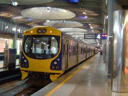
 An EMU sits at the newly electrified Britomart station. | |||||||||||||||||||||||
| Location | Auckland CBD | ||||||||||||||||||||||
| Owned by | Auckland Council[1] | ||||||||||||||||||||||
| Line(s) |
North Island Main Trunk Newmarket Line | ||||||||||||||||||||||
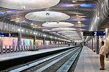
| Platforms | 5 | ||||||||||||||||||||||
| Tracks | 2 | ||||||||||||||||||||||
| Construction | |||||||||||||||||||||||
| Platform levels | 1 | ||||||||||||||||||||||
| Bicycle facilities | Yes | ||||||||||||||||||||||
| Other information | |||||||||||||||||||||||
| Station code | BMT / AKL | ||||||||||||||||||||||
| History | |||||||||||||||||||||||
| Opened | 7 July 2003 | ||||||||||||||||||||||
| Electrified | 25kV AC (2014) | ||||||||||||||||||||||
| Traffic | |||||||||||||||||||||||
| 7.49 million (2015)[2] | |||||||||||||||||||||||
| Services | |||||||||||||||||||||||
| |||||||||||||||||||||||
| Designated | 11 July 1986 | ||||||||||||||||||||||
| Reference no. | 101 | ||||||||||||||||||||||
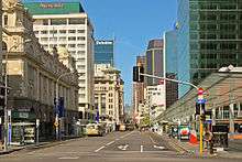
Britomart Transport Centre is the public transport hub in the central business district of Auckland, New Zealand, and the northern terminus of the North Island Main Trunk railway line. It combines a bus interchange with a railway station in a former Edwardian post office, extended with expansive post-modernist architectural elements. It is at the foot of Queen Street, the main commercial thoroughfare of Auckland city centre, with the main ferry terminal just across Quay Street.
The centre was the result of many design iterations, some of them being substantially larger and including an underground bus terminal and a large underground car park. Political concerns and cost implications meant that those concepts did not proceed. However, at the time of its inception in the early 2000s the centre was still Auckland's largest transport project ever, built to move rail access closer to the city's CBD and help boost Auckland's low usage of public transport. It is one of the few underground railway stations in the world designed for use by diesel trains.[3]
Initially seen as underused and too costly, it is now considered a great success, heading for capacity with the growing uptake of rail commuting. Limitations on further patronage are primarily due to the access tunnel from the east which provides only two rail tracks, and the lack of a through connection via a rail link to the North Shore or to the Western line via an underground tunnel, which would change it into a through station.
History
Cost over-runs and differing tastes made the centre politically controversial, the design often being described as a large hole in the ground, both literally and figuratively. Despite this and a NZ$204 million price tag,[4] it has won numerous design awards and is internationally recognised for its innovative but heritage-sympathetic architecture.[5] The main source of contention was the relatively great expense of this public transport development in the Auckland Region which is traditionally very focused on the private car.[6]
Earlier uses
Britomart is on reclaimed land in the middle of what was once Commercial Bay. It is named after Point Britomart, a former headland at Commercial Bay's eastern end. In the 1870s and 1880s the headland was levelled in order to extend the railway line to the bottom of Queen Street, and was used to fill in Commercial Bay.[7]
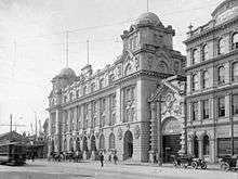
Auckland Railway Station moved west from its original 1873 site to Britomart in 1885 and remained there after the Post Office was built on the Queen Street frontage in 1911. In 1930 the station was relocated 1.2 km east to Beach Road and the former station site became a bus terminal in 1937 and car park in 1958.[7]
Many proposals were made to locate the station back in the CBD, most notably in 1973 and 1987, with the 1970s proposal of the Mayor of Auckland, Dove-Myer Robinson, envisaging an underground station at Britomart and a tunnel loop, but that was stopped by the Muldoon National Government, which claimed it was unjustified and too costly.[8] In 1995, Auckland City Council purchased the old Post Office (PostBank offices closed in 1988,[8] though some postal services remained open beyond that year) and proposed to redevelop the area as a transit centre.
Early designs called for both the bus terminal and the railway to be underground, but these plans were scrapped as consultation showed that buses were preferred above ground by both users and operators, and projected costs soared, partly due to the difficulties with potential water ingress. The developer eventually defaulted on contractual deadlines, and the project failed.[1][9][10]
In 1998, a cheaper option was decided on, partly after a consultation process with stakeholders and citizens. The architectural design was chosen via a competition. It used part of Queen Elizabeth II Square and surrounding streets as a bus terminal, with the existing dilapidated bus terminal redeveloped to incorporate both bus services and a pedestrianised area. When nearby Quay Street was realigned in the late 1990s, a tunnel was built (completed in 2000) to provide the underground railway link. Bus services using the old bus terminal were diverted to other locations in June 2001.[1][9][10]
Construction
Overview
Designed by California architect Mario Madayag in collaboration with local Auckland architects Jasmax,[1][4][4][11] construction of Britomart commenced in October 2001, with structural design having been provided by OPUS.[12] It involved 14 km of piling, some being 40 m long and driven 16 m into the underlying bedrock, mainly to provide good earthquake protection, and to futureproof the area for potential later construction of buildings on top of the station. 200,000 cubic metres were excavated for the station, and 40,000 cubic metres of concrete poured.[13] The station has a site area of 5.2 ha and includes 236 m² retail area.[1]

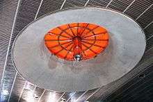
The main chamber of Britomart is one of the best interiors in New Zealand and shows the influence of the main hall of the Austrian Postal Savings Bank building by Otto Wagner.
The station opened to passengers on 7 July 2003, with the official opening on 25 July 2003 by Sir Edmund Hillary and government ministers.[14] Services to the Beach Road terminus ceased, except for some peak-time commuter services and excursion trains using the former Platform 4 (originally Platform 7), renamed 'The Strand'. The commuter services ceased after a few months.
Pedestrian underpasses
Initial plans included underground pedestrian walkways to Queen Elizabeth II Square, the nearby downtown ferry terminal and the main shopping street of Queen St. Due to cost over-runs only the short walkway under Queen Street to the square was built, the other two being dropped in favour of a sizeable rain-proof canopy that ran from the square's above-ground exit northward toward the ferry terminal and southward toward the Queen Street-Customs Street intersection.
The underground walkway was closed to pedestrians from 29 March 2016 in order to facilitate preliminary works for the City Rail Link.[15] In April and May 2016, the canopy was dismantled and removed from the site, and on 28 May 2016 the Downtown Shopping Centre was closed and fenced off for demolition.[16]
Further works
A major commercial building was built over the eastern approach tunnel in the late 2000s, at the eastern edge of the plaza behind the centre.[17]
The Downtown Shopping Centre was closed on 28 May 2016 and by 23 November had been demolished. It will be replaced with a 36-storey skyscraper which will include a new shopping centre in the lower levels. Auckland Council and proprietors Precinct Properties struck a deal to include tunnels for the City Rail Link directly underneath the premises.[18][19]
Capacity and rail connections
The station is designed to serve up to 10,500 passengers during the peak hour as a terminus.[4] Capacity increases will probably not be possible without turning Britomart into a through station, with a tunnel underneath Auckland CBD (see City Rail Link section below).
The station has five platforms, and is constrained by the 9.3 m width of the 426 m long double-track access tunnel. Early forecasts predicted that while double-tracking of the surrounding rail network would improve peak time train congestion, the capacity of the corridor would not be reached until about 2020.[20] Growth in train patronage and increased services resulted in the tunnel being at maximum capacity from 2011, almost 10 years earlier than predicted.[21] Because of the capacity restrictions, a proposed Hamilton-Auckland commuter train service would have gone to the The Strand station some 1.5 km to the east.[22]
Increased services
In its early days, Britomart received a lot of criticism due to it being built on a scale and level of grandeur that was well in excess of the capacity and patronage of the rail network. Auckland Regional Council transport committee chairwoman Catherine Harland acknowledged that "Britomart opened ahead of its time", raising public expectations that could not be fulfilled at the time due to the state of the rail network.[23]
Patronage increased from 2.5 million journeys in 2003 to just over 14.2 million in July 2015.[24]
The foresight of council planners in constructing such an iconic investment has spurred further development. The $600 million Project DART (Developing Auckland's Rail Transport)[25] was undertaken, with the state-owned enterprise ONTRACK (now KiwiRail) providing the ‘below rail’ construction (i.e. platforms, tracks and signals) and ARTA providing the passenger services and facilities at stations (i.e. lighting, shelters and access), with funding from the Auckland Regional Council and Land Transport New Zealand.
Electrification
It was announced on 17 May 2007 that electrification of Auckland's rail network would proceed. Installation of overhead wires began later, with Auckland Transport (initially ARTA) purchasing new electric units to replace the diesel trains. The project was expected to be completed in 2013.[26]
Britomart was officially electrified on 31 March 2014, with New Zealand's Prime Minister, John Key, flipping the switch in a commemorative ceremony.[27] The first electric passenger services began running four weeks later, between Britomart and Onehunga on the Onehunga Line on 28 April 2014.[28]
From July 2015, all suburban trains serving Britomart were operated by AM Class EMUs, leaving the thrice-weekly Northern Explorer as the only diesel service using the station. By December 2015, the stations required a $600,000 upgrade to its diesel extraction fans and Auckland Transport requested that KiwiRail, the operator of the Northern Explorer, fund the upgrade if they wished to continue serving the station. KiwiRail decided that the cost was not justifiable and from 21 December 2015 they ceased serving Britomart and relocated their Auckland terminus to Strand Station, in the east of the CBD.
City Rail Link
Plans for a tunnel southward underneath the CBD to Mt Eden and even to Morningside were debated for nearly a century.[29][30] With Britomart in operation since 2003, the tunnel would allow trains to run through the station rather than having to reverse out over the same set of tracks.
On 5 March 2008 ARTA said that it had begun preliminary planning for a 3.5 km tunnel which would most likely be travelling under Albert Street and serving three underground stations: one near Wellesley Street (linking to Aotea Square), one in the Karangahape Road / Pitt Street area, and one near Upper Symonds Street in Newton. At the southern end, the line would link to a redeveloped station at Mt Eden.[20][31]
Original estimates for the cost of the CRL were at around $1 billion, taking 5–7 years to plan and build.[32][33] In August 2014 it was announced that the station at Newton had been dropped in favour of an upgraded station at Mt Eden.[34]
Eastern tunnel capacity
A proposed alternative to the City Rail Link (CRL) to increase capacity was the duplication of the existing eastern Britomart approach tunnel. This would have required a new twin track tunnel approximately 500 metres long to be constructed parallel to the existing twin-track tunnel, resulting in four tracks from Quay Park Junction and retaining Britomart as a terminus. Estimated costs were $150 million to $200 million, with 4–5 years to plan and build.[35] Such a project would have allowed the same capacity increase as the CRL at approximately one sixth to one fifth the cost, but without any of the additional benefits that the two new CRL underground stations or the more direct route to the Western Line will provide.
Initially seen as an inferior, but cheaper and more politically acceptable alternative to the CRL tunnel, the duplicate eastern approach also gained favour as a stop gap implementation due to the comparatively short build time. Even if planning had commenced immediately, the CRL might not have become operational until several years after the maximum capacity of the existing corridor was reached.[35] Moreover, while seen as an alternative to the CRL through connection tunnel, the duplicate eastern tunnel would not have precluded it from being built.
A feature that came into operation in 2011 in time for the 2011 Rugby World Cup and allowed an increase in capacity of the existing tunnel is 'bi-directional signalling', which allows a train to leave on the same track on which it entered - freeing it from having to cross over other tracks which may not be safely clear of other trains.[36]
Services
Trains
Transdev operates the Auckland suburban rail network on behalf of Auckland Transport. This includes the electrified lines west to Swanson and south to Onehunga, Manukau and Papakura, plus the diesel shuttle service between Papakura and Pukekohe.
In July 2015, it was reported that the number of trains able to enter and leave Britomart was 20 per hour.[37] On a typical weekday inter-peak, eleven trains leave Britomart per hour, comprising:
- 3 trains per hour to Manukau via Glen Innes and Otahuhu (Eastern Line)
- 3 trains per hour to Papakura via Newmarket and Otahuhu (Southern Line), with 1 diesel train shuttle service per hour on the Papakura-Pukekohe non-electrified section
- 3 trains per hour to Swanson via Newmarket, New Lynn and Henderson (Western Line)
- 2 trains per hour to Onehunga (Onehunga Line)
Buses and ferries
Britomart is a major interchange between trains, buses and ferries. It is the terminus for many bus routes, including the Skybus route to Auckland Airport and the Northern Express (NEX) route along the Northern Busway to Albany and the Hibiscus Coast. The very frequent City Link and Inner Link bus services also stop at Britomart. Buses depart from stops on the surrounding streets, some of which are up to a block away from the station. The lack of more integrated bus facilities has been the subject of criticism, particularly due to the fact that the original design for the transport centre included an underground bus station, which was cut from the final design due to costs and the bus operators' preference for above-ground bus facilities.[1] Until early 2016, buses arrived at and departed from Queen Street in front of the station building, but that portion of Queen Street is currently closed to vehicular traffic while trench works for the City Rail Link take place.
Across Quay Street from the station is the Auckland Ferry Terminal, which is the main hub for Auckland's ferry system. There are ferry services to suburbs including Devonport, Birkenhead and Half Moon Bay, as well as to islands in the Hauraki Gulf such as Waiheke Island and Rangitoto Island.
Heritage registration
The Chief Post Office was registered as a Category I heritage building by the New Zealand Historic Places Trust on 11 July 1986, with registration number 101.[38]
Awards
Awards that the centre has received:[4]
- 2004 Property Council of New Zealand - Merit Award, Special Purposes Category
- 2004 American Institute of Architecture[39] - Architectural Record / Business Week International Winner
- 2004 New Zealand Institute of Architects - Resene Award, Community and Cultural
- 2004 New Zealand Institute of Architects - Resene Award, Heritage and Conservation
- 2004 Illuminating Engineering Society of Australia and New Zealand - Lighting Award
- 2004 New Zealand Concrete Society - Concrete Award
- 2005 New Zealand Institute of Architects - Resene New Zealand Award for Architecture, Community & Cultural
- 2007 Kenneth F. Brown Asia Pacific Culture and Architecture Design Award - Honorable mention[40]
See also
References
- 1 2 3 4 5 6 Urban Design Case Studies - New Zealand Ministry for the Environment, March 2005, ISBN 0-478-18995-8
- ↑ L, Matt (5 August 2015). "2015 Station Boarding Results - TransportBlog". Transport Blog. Retrieved 9 May 2016.
- ↑ Dearnaley, Mathew (20 February 2007). "Smoke chaos at Britomart". The New Zealand Herald. Retrieved 22 September 2011.
- 1 2 3 4 5 6 Cultural & Civic Projects - Britomart Transport Centre Archived 31 May 2007 at the Wayback Machine. (from the Jasmax website)
- ↑ References provided within this same article (Awards)
- ↑ Mode of Transport, Figure for New Zealand Regions (from the Travel Survey Highlights 1997-98, New Zealand Ministry of Transport)
- 1 2 Chapter 1 - The Historic Land 1600-1959 (from the official Centre website)
- 1 2 Chapter 2 - City Takes Control 1959-1995 (from the official Centre website)
- 1 2 Chapter 3 - Transforming the Waterfront 1995-1999 (from the official Centre website)
- 1 2 Chapter 4 - The Britomart Project 1999-2001 (from the official Centre website)
- ↑ Orsman, Bernard (9 November 2000). "Auckland City vision a transport of delights". The New Zealand Herald. Retrieved 22 September 2011.
- ↑ Bennett, Adam (24 September 2007). "Opus IPO set to ride out volatility". The New Zealand Herald. Retrieved 22 September 2011.
- ↑ First Britomart Tour – Wednesday 29 November 2006 - IPENZ, Auckland Branch, January 2007 Bulletin
- ↑ Ministers at the opening of Britomart Archived 27 September 2007 at the Wayback Machine. (from the New Zealand Labour Party website)
- ↑ "QEII Square pedestrian underpass closure". Auckland Transport. 21 March 2016. Retrieved 16 April 2016.
- ↑ "End of an era for Auckland's downtown mall". NZ Herald. 28 May 2016. Retrieved 31 May 2016.
- ↑ Gibson, Anne (27 May 2009). "Two towers take shape at $1b Britomart centre". The New Zealand Herald. Retrieved 22 September 2011.
- ↑ Catherine Gaffaney (22 May 2016). "Last week for shoppers at Auckland downtown mall". NZ Herald.
- ↑ "Watch $850m project: preparing for NZ's biggest commercial development". NZ Herald. 23 November 2016. Retrieved 23 November 2016.
- 1 2 Mathew Dearnaley (5 March 2008). "$1b loop tunnel plan to unlock Britomart". The New Zealand Herald. Retrieved 5 March 2008.
- ↑ "Britomart nears capacity". Auckland Transport Blog. 17 August 2010. Retrieved 15 May 2011.
- ↑ "Strand rail link 'best'". Waikato Times. 11 May 2011. Retrieved 15 May 2011.
- ↑ "Happy birthday, Britomart". The New Zealand Herald. 7 July 2004. Retrieved 22 September 2011.
- ↑ "Auckland rail patronage hits a new high of 14 million". stuff.co.nz. 4 August 2015. Retrieved 4 February 2016.
- ↑ Rail Newsletter Issue 29 (published on the Auckland Regional Transport Authority (ARTA) website, late 2006)
- ↑ 21st century public transport for Auckland - Auckland Regional Transport Authority, Thursday 17 May 2007
- ↑ "Auckland rail network enters new era". The New Zealand Herald. 31 March 2014. Retrieved 14 May 2014.
- ↑ "Electric trains". Auckland Transport. Retrieved 24 May 2014.
- ↑ "Abandonment Of Scheme". NZ Herald. 15 March 1930.
- ↑ "Badly Let Down". Auckland Star. 22 March 1930.
- ↑ Auckland’s rail network tomorrow: 2016 to 2030 Archived 28 September 2007 at the Wayback Machine. (from the ARTA, August 2006)
- ↑ Following the money - e.nz magazine, IPENZ, January/February 2007
- ↑ Dearnaley, Mathew (21 May 2007). "$1b Auckland rail upgrade powers ahead". The New Zealand Herald. Retrieved 22 September 2011.
- ↑ "Underground station dropped from Auckland city rail link". TVNZ. 1 August 2014. Retrieved 22 January 2016.
- 1 2 Britomart West Rail Extension Feasibility Study (URS Group, final report for Auckland City Rapid Transit Group, 2004)
- ↑ "More about electrification". Kiwirail. Retrieved 14 January 2015.
- ↑ "Auckland rail patronage three years ahead of target". NZ Herald. 24 July 2015. Retrieved 3 April 2016.
- ↑ "Chief Post Office". Register of Historic Places. Heritage New Zealand. Retrieved 9 June 2012.
- ↑ Britomart Transport Centre (from the Architectural Record website)
- ↑ School of Architecture announces winners of the 2007 Kenneth F. Brown... - UH News, University of Hawaii, Thursday 7 June 2007
External links
| Wikimedia Commons has media related to Britomart Transport Centre. |
- Britomart Project (from the Auckland City Council website)
- Britomart Transport Centre (BTC official website)
- Photographs of Britomart Transport Centre held in Auckland Libraries' heritage collections.
Coordinates: 36°50′38″S 174°46′01″E / 36.844014°S 174.767010°E