Brooke, Norfolk
| Brooke | |
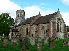 Brooke St Peter |
|
 Brooke |
|
| Area | 8.72 km2 (3.37 sq mi) |
|---|---|
| Population | 1,399 (2011) |
| – density | 160/km2 (410/sq mi) |
| OS grid reference | TG293001 |
| Civil parish | Brooke |
| District | South Norfolk |
| Shire county | Norfolk |
| Region | East |
| Country | England |
| Sovereign state | United Kingdom |
| Post town | NORWICH |
| Postcode district | NR15 |
| Dialling code | 01508 |
| Police | Norfolk |
| Fire | Norfolk |
| Ambulance | East of England |
| EU Parliament | East of England |
| UK Parliament | South Norfolk |
Coordinates: 52°33′00″N 1°22′59″E / 52.550°N 1.383°E
Brooke is a village and civil parish in the South Norfolk district of Norfolk, England, about 7 miles south of Norwich and roughly equidistant from Norwich and Bungay. According to the 2001 census it had a population of 1,242 in 554 households,[1] including Howe the population increasing to 1,399 at the 2011 census.[2]
The church of Brooke St Peter is one of 124 existing round-tower churches in Norfolk.
In common with most small Norfolk villages public services are few, however the village is better served than most by one primary school (Brooke Primary), a garage and petrol station, post office, farm store & butcher, two pubs including a popular restaurant. One further convenience store is located at the warden-patrolled elderly housing development Churchill Place.
Governance
An electoral ward of the same name exists. This ward had a total population of 2,662 at the 2011 Census.[3]
Notable residents
- Sir Astley Paston Cooper, 1st Baronet (23 August 1768 – 12 February 1841), English surgeon and anatomist, who made historical contributions to otology, vascular surgery, the anatomy and pathology of the mammary glands and testicles, and the pathology and surgery of hernia.
- Edward Brian (Ted) Seago RBA ARWS RWS (31 March 1910 – 1974) was an English artist who painted in both oils and watercolours, who lived at Brooke Lodge.
- Bernard Matthews, (24 January 1930 – 25 November 2010), founder of the poultry empire Bernard Matthews Farms, the son of a mechanic, was born in Brooke, in 1930.
- Transsexual model Caroline Cossey was born in Brooke on 31 August 1954. She appeared as a James Bond girl and was the first acknowledged transsexual to pose for Playboy magazine.
Notes
- ↑ "Brooke parish information". 25 September 2007. Retrieved 20 June 2009.
- ↑ "Parish population 2011". Retrieved 5 September 2015.
- ↑ "Ward population 2011". Retrieved 5 September 2015.
External links
| Wikimedia Commons has media related to Brooke, Norfolk. |