Scole
| Scole | |
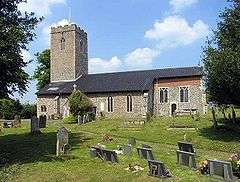
 St Andrew's Church, Scole |
|
 Scole |
|
| Area | 14.31 km2 (5.53 sq mi) |
|---|---|
| Population | 1,367 |
| – density | 96/km2 (250/sq mi) |
| OS grid reference | TM149789 |
| Civil parish | Scole |
| District | South Norfolk |
| Shire county | Norfolk |
| Region | East |
| Country | England |
| Sovereign state | United Kingdom |
| Post town | DISS |
| Postcode district | IP21 |
| Police | Norfolk |
| Fire | Norfolk |
| Ambulance | East of England |
| EU Parliament | East of England |
Coordinates: 52°21′58″N 1°09′22″E / 52.36616°N 1.15616°E
Scole is a village on the Norfolk–Suffolk border in England. It is 19 miles south of Norwich and lay on the old Roman road to Venta Icenorum, which was the main road until it was bypassed with a dual carriageway. It covers an area of 14.31 km2 (5.53 sq mi) and had a population of 1,339 in 563 households at the 2001 census,[1] the population increasing to 1,367 at the 2011 Census.[2]
It lies on the North bank of the River Waveney.
Scole is the birthplace of William Gooderham (1792), founder of the Gooderham and Worts distillery in Toronto, Canada, later to be the largest in the British Empire.
The Crossways (the villages local pub) is known for its karaoke nights and legendary connection.
Governance
An electoral ward in the same name exists. This ward stretches east to Needham and at the 2011 Census had a total population of 2,357.[3]
See also
- Scole Experiment, a series of mediumistic séances which took place in the village
Notes
- ↑ "Scole parish information". South Norfolk Council. 17 May 2007. Retrieved 20 June 2009.
- ↑ "Parish population 2011". Retrieved 9 September 2015.
- ↑ "Ward population 2011". Retrieved 9 September 2015.
References
External links
| Wikimedia Commons has media related to Scole. |