Brough, Cumbria
| Brough | |
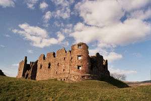 Brough Castle from the south east |
|
 Brough |
|
| Population | 751 (2011 including Helbeck) |
|---|---|
| OS grid reference | NY794145 |
| Civil parish | Brough |
| District | Eden |
| Shire county | Cumbria |
| Region | North West |
| Country | England |
| Sovereign state | United Kingdom |
| Post town | KIRKBY STEPHEN |
| Postcode district | CA17 |
| Dialling code | 017683 |
| Police | Cumbria |
| Fire | Cumbria |
| Ambulance | North West |
| EU Parliament | North West England |
| UK Parliament | Penrith and the Border |
Coordinates: 54°31′32″N 2°19′08″W / 54.52561°N 2.31875°W
Brough (/brʌf/), sometimes known as Brough under Stainmore, is a village and civil parish in the Eden district of Cumbria, England, on the western fringe of the Pennines near Stainmore. The village is on the A66 trans-Pennine road, and the Swindale Beck, and is about 8 miles (13 km) south east of Appleby-in-Westmorland. Brough is situated 5 miles (8.0 km) north east of Kirkby Stephen and 28 miles (45 km) north east of Kendal on the A685.
Brough lies within the historic county of Westmorland. At the 2001 census it had a population of 680, increasing to 751 at the 2011 Census.[1]
History
The village is on the site of the Roman fort of Verterae ("The Forts"),[2] on the northern leg of the Roman-era Watling Street, linking Luguvalium (Carlisle) with Eboracum (York) and points south.[3] The area of the rectangular fort, which once occupied the land to the south of the Swindale Beck, is now a Scheduled Ancient Monument.[4] Brough Castle was built in the 11th century within the northern part of the former fort.
Brough has historically been divided into Market Brough, to the north, and Church Brough, to the south and centred on the castle and St Michael's Church. In 1977 this division was made physical by the construction of the Brough bypass dual carriageway, taking the A66 away from the village main street.
Up to some time before 1777, opposite the market cross going up towards Stainmore, there was a holy well dedicated to Saint Winifred (Gwenfrewi), which before the Reformation was a place of pilgrimage.[5]
Nearby is Augill Castle, built in 1841 by John Bagot Pearson from Kirkby Lonsdale as a weekend retreat and now a hotel.
The holly tree tradition
Traditionally, on Twelfth Night, a burning holly tree (subsequently, ash trees were used) would be carried through the village, followed by a brass band. When the flames had partially gone out, the villagers would try to bring the tree to a pub, where the party would continue until the early hours of the morning.[6][7] The village was also the venue for a popular fair on the second Thursday of March.[8]
St Michael's church
St Michael's Church is a large building with an impressive tower. The oldest parts date from the Norman period, and may have suffered during William I of Scotland's attack on the castle in 1174. The church was enlarged in the 14th century, to add the north aisle, and in the early 16th century when most of the existing structure was built. The tower was constructed by Thomas Blenkinsop of Helbeck in 1513. There is a large war memorial within the nave. There are four bells. Repairs and improvements continue to this day. Further information can be found at the parish website.
Gallery
 Parading the holly tree
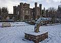 Augill Castle
 St Michael's Church.
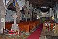 Interior of St Michael's church
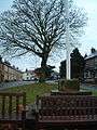 Church Brough - The Green
 The Coronation clock tower
Governance
An electoral ward in the name of Brough exists. This ward stretches from Musgrave to Stainmore with a total population of 1,317.[9]
See also
References
| Wikimedia Commons has media related to Brough, Cumbria. |
- ↑ "Parish population 2011". Retrieved 20 June 2015.
- ↑ Gordon, Seton (1949). Highways and Byways in the Central Highlands. London: Macmillan & Co. p. 152. Full text in SGML format
- ↑ Antonine Itinerary. British Route 2.
- ↑ .
- ↑ Jim Taylor Page, Cumbrian Holy Wells, North West Catholic Hist. Soc., Wigan 1990, p. 21; J. Nicolson & R. Burn, History and Antiquities of the Counties of Westmorland and Cumberland, Vol. I, London 1777, p. 575.
- ↑ "Holly Night at Brough", The Every-day Book and Table Book; or, Everlasting Calendar of Popular Amusements, Sports, Pastimes, Ceremonies, Manners, Customs, and Events, Each of the Three Hundred and Sixty-Five Days, in Past and Present Times; Forming a Complete History of the Year, Months, and Seasons, and a Perpetual Key to the Almanac, Including Accounts of the Weather, Rules for Health and Conduct, Remarkable and Important Anecdotes, Facts, and Notices, in Chronology, Antiquities, Topography, Biography, Natural History, Art, Science, and General Literature; Derived from the Most Authentic Sources, and Valuable Original Communication, with Poetical Elucidations, for Daily Use and Diversion. Vol III., ed. William Hone, (London: 1838) p 26-27. Retrieved on 2008-06-06
- ↑ "Westmoreland", British Popular Customs Present And Past, p 35. Retrieved on 2008-06-06
- ↑ "March Fair, at Brough, Westmoreland", The Every-day Book... , ed. William Hone, (London: 1838) p 317-19. Retrieved on 2008-06-11
- ↑ "Ward population 2011". Retrieved 20 June 2015.
Cumbria Portal | |
| Boroughs or districts | |
| Major settlements |
|
| Topics | |