Pennines
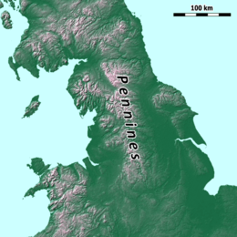
The Pennines /ˈpɛnaɪnz/, also known as the Pennine Chain or Pennine Hills,[1] are a range of mountains and hills in Northern England separating North West England from Yorkshire and North East England.
Often described as the "backbone of England",[2][3][4] the Pennine Hills form a more-or-less continuous range stretching northwards from the Peak District in the north Midlands, into the South Pennines incorporating parts of Lancashire, Yorkshire and Greater Manchester, through the Yorkshire Dales and North Pennines past the Cumbrian Fells up to the Tyne Gap, which separates the range from the Cheviot Hills. North of the Aire Gap, the Pennines' western spur into North Lancashire forms the Bowland Fells which are also considered separate from the Pennines, and south of the gap is a spur into east Lancashire, comprising the Rossendale Fells and West Pennine Moors.[5] The Pennines are an important water catchment area with numerous reservoirs in the head streams of the river valleys.
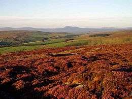
The region is widely considered to be one of the most scenic areas of the United Kingdom.[6] The North Pennines and Nidderdale are designated Areas of Outstanding Natural Beauty (AONB), as are Bowland and Pendle Hill.[7] Parts of the Pennines are incorporated into the Peak District National Park, the Yorkshire Dales National Park and the Northumberland National Park.[8] Britain's oldest long-distance footpath, the Pennine Way, runs along most of the Pennine Chain and is 268 miles (429 km) long.[9]
The Cheviot Hills, separated by the Tyne Gap and the Whin Sill, along which run the A69 and Hadrian's Wall, are not part of the Pennines but, perhaps because the Pennine Way crosses them, they are often treated as such, and as a result the northern end of the Pennines may be considered to be either at the Tyne Gap or the Cheviot Hill fringes on the Anglo-Scottish border. Conversely the southern end of the Pennines is commonly said to be in the High Peak of Derbyshire at Edale, the start of the Pennine Way, although hills continue towards the Stoke-on-Trent area in northern Staffordshire and into eastern, southern and western parts of Cheshire, Derbyshire and Nottinghamshire respectively.
Name

Various etymologies have been proposed treating "Pennine" as though it were a native Brittonic/Modern Welsh name related to pen- ("head") .[10] In fact, it did not become a common name until the 18th century and almost certainly derives from modern comparisons with the Apennine Mountains, which run down the middle of Italy in a similar fashion.[11]
Following an 1853 article by Arthur Hussey,[12] it has become a common belief that the name derives from a passage in The Description of Britain (Latin: De Situ Britanniæ),[13] an infamous historical forgery concocted by Charles Bertram in the 1740s and accepted as genuine until the 1840s. In 2004, George Redmonds reassessed this, finding that numerous respected writers passed over the origin of the mountains' name in silence even in works dedicated to the topological etymology of Derbyshire and Lancashire.[11] He found that the derivation from Bertram was widely believed and considered uncomfortable.[11] In fact, he found repeated comparisons going back at least as early as Camden,[15] many of whose placenames and ideas Bertram incorporated into his work. Bertram was responsible (at most) with popularizing the name against other contenders such as Daniel Defoe's "English Andes".[11] His own form of the name was the "Pennine Alps" (Alpes Peninos), which today is used for a western section of the continental Alps. Those mountains derive their name from the Latin Alpes Pœninæ, the St Bernard Pass whose name has been variously derived from the Carthaginians,[16] a local god,[17] and Celtic peninus.[18] This was also the pass used in the invasions of Italy by the Gallic Boii and Lingones in 390 BC. The etymology of the Apennines themselves—whose name first referred to their northern extremity and then later spread southward—is also disputed but is usually taken to derive from some form of Celtic pen or ben ("mountain, head").[19][20][21][22]
Various towns and geographical features within the Pennines retain Celtic names, including Penrith, the fell Pen-y-ghent, the River Eden, and the area of Cumbria. More commonly, local names result from later Anglo-Saxon and Norse settlements. In Yorkshire and Cumbria, many words of Norse origin, not commonly used in standard English, are part of everyday speech: for example, gill (narrow steep valley), beck (brook or stream), fell (hill), and dale (valley).[23]
Geography and geology

The northern Pennine range is bordered by the Eden Valley, foothills of the Lake District and the other Cumbrian Fells in the north west, the Tyne Gap, Anglo-Scottish border and Cheviot Hills in the north, the lowlands, ridges and coastlines of Northumberland, Tyne and Wear and County Durham in the north east. This is located within eastern parts of Cumbria, southern parts of Northumberland, and western parts of Yorkshire and County Durham. The western side borders the West Lancashire Coastal Plain, Lancashire Coalfield, the Mersey Valley, and the Cheshire Plain within eastern parts of Cheshire and northern and eastern parts of Lancashire and the Greater Manchester conurbation. The eastern side borders the vales of Mowbray and York, and the low-lying ridges of the South Yorkshire Coalfield and Southern Magnesian Limestone[24] (including the Misk Hills of Nottinghamshire) leading to the Humberhead Levels, the Sherwood Forest, and the lower valley of the River Trent.[25] This is within western parts of Yorkshire and eastern parts of Derbyshire with foothills also continuing into western parts of Nottinghamshire. The southern extent of the range is bordered by the Needwood & South Derbyshire Claylands,[26] and the middle valley of the River Trent [27] all forming the low-lying area of the Midlands with the Weaver Hills of Staffordshire considered to be the most southerly major hills of the range. This is within the Stoke-on-Trent conurbation of northern Staffordshire and the southern parts of Derbyshire above the city of Derby. Apart from the uplands in the Lake District fringes, other Cumbrian Fells, and Cheviot Hills, most of the areas bordering the Pennines are predominantly lowlands.
The Pennines have been carved from a series of geological structures whose overall form is a broad anticline whose axis extends in a north–south direction. The North Pennines are coincident with the Alston Block, whilst the Yorkshire Dales are coincident with the Askrigg Block. In the south the Peak District is essentially a flat-topped dome. Each of these structures consists of Carboniferous limestone overlain with Millstone Grit. The limestone is exposed at the surface in the north of the range, in the North Pennines AONB, and in the south in the Derbyshire Peak District. In the Yorkshire Dales and the White Peak the limestone exposure has led to the formation of large underground cave systems and watercourses. In the Dales the caves or potholes are known as "gills" and "pots" in the Yorkshire dialect, and are prevalent on the eastern side. They include some of the largest caves in England at Gaping Gill, more than 350 ft (107 m) deep and Rowten Pot, 365 ft (111 m) deep. Titan in the Peak District, the deepest shaft known in Britain, is connected to Peak Cavern in Castleton, Derbyshire, the largest cave entrance in the country. Erosion of the limestone has led to some unusual geological formations, such as the limestone pavements at Malham Cove. Between the northern and southern areas of exposed limestone (between Skipton and the Dark Peak) lies a narrow belt of exposed gritstone. Here the shales and sandstones of the Millstone Grit form high hills occupied by a moorland of bracken, peat, heather and coarse grasses;[28] the higher ground is uncultivable and barely fit for pasture.
Most of the Pennine landscape is characterised by upland areas of high moorland indented by more fertile river valleys, although the landscape varies in different areas. The Peak District consists of hilly plateaus cut by river valleys and gorges in the White Peak, and moorlands, plateaus, edges and uplands in the Dark Peak[29] and South West Peak.[30] The moorlands of the Dark Peak extend into the South Pennines which consist of hilly landscape and narrow valleys between the Peak District, Forest of Bowland and Yorkshire Dales.[31] Bowland is dominated by a central upland landform of deeply incised gritstone fells covered with tracts of heather-covered peat moorland and blanket bog. The lower slopes of the fells are dotted with stone-built farms and small villages and are criss-crossed by drystone walls enclosing reclaimed moorland pasture. Steep-sided wooded valleys link the upland and lowland landscapes. In the northeast of the area are extensive coniferous plantations and the eastern limestone areas support high-quality species-rich meadows.[32] The landscape becomes higher and more mountainous at the Yorkshire Dales and North Pennines. The Yorkshire Dales are characterised by moorlands, river valleys, hills, fells and mountain peaks[33] while the North Pennines consist of high upland plateaus, moorlands, fells, edges and valleys with most of the area containing flat topped hills while the higher peaks are in the western half.[34]
Elevation
Rising less than 3,000 feet, the Pennines are often referred to as fells. The highest is Cross Fell in eastern Cumbria, at 2,930 feet (893 m), while other principal peaks at the North Pennines include Great Dun Fell 2,782 ft (848 m), Mickle Fell 2,585 ft (788 m), and Burnhope Seat 2,451 ft (747 m). Principal peaks at the Yorkshire Dales include Whernside 2,415 ft (736 m), Ingleborough 2,372 ft (723 m), High Seat 2,328 ft (710 m) and Wild Boar Fell 2,324 ft (708 m), both in Mallerstang, and Pen-y-ghent 2,274 ft (693 m). Principal peaks at the Forest of Bowland include Ward's Stone 1,841 ft (561 m), Fair Snape Fell 1,710 ft (521 m), and Hawthornthwaite Fell 1,572 ft (479 m). Principal peaks at the South Pennines and Peak District include Kinder Scout 2,087 ft (636 m) and Bleaklow 2,077 ft (633 m) in Derbyshire, Black Chew Head 1,778 ft (542 m) in Greater Manchester, and Winter Hill 1,496 ft (456 m).
Drainage

For much of their length the Pennines form the main watershed in northern England, dividing east and west. The rivers Eden, Ribble, Dane and tributaries of the Mersey (including the Irwell, Tame and Goyt) flow westwards towards the Irish Sea. On the eastern side of the watershed, the rivers Tyne, Tees, Wear, Swale, Ure, Nidd, Calder, Wharfe, Aire and Don rise in the region and flow eastwards to the North Sea. The River Trent, however, rises on the western side of the Pennines before flowing around the southern end of the range and up the eastern side; together with its tributaries (principally the Dove and Derwent) it thus drains both east and west sides of the southern end to the North Sea.
Climate

The Pennine climate is generally temperate like that of the rest of England, but the hills have more precipitation, stronger winds and colder weather than the surrounding areas. Some areas could be described as Oceanic climate verging on Subarctic climate and a small area in Teesdale is classified as subarctic. More snow falls on the Pennines than on surrounding lowland areas due to the elevation and distance from the coast; unlike lowland areas of England, the Pennines can have quite severe winters.
The northwest is amongst the wettest regions of England and much of the rain falls on the Pennines. The eastern side is drier than the west—the rain shadow shields northeast England from rainfall that would otherwise fall there.
Precipitation is important for the area's biodiversity and human population. Many towns and cities are located along rivers flowing from the hills and in northwest England the lack of natural aquifers is compensated for by reservoirs.
Water has carved out gorges, caves and limestone landscapes in the Yorkshire Dales and Peak District. In some areas precipitation has contributed to poor soils, resulting in part in moorland landscapes that characterize much of the range. In other areas where the soil has not been degraded, it has resulted in lush vegetation.
The Pennines are in climate zones 7 and 8: zone 8 is common throughout most of the UK and zone 7 is the UK's coldest climatic zone. The Pennines, Scottish Highlands, Southern Uplands and Snowdonia are the only areas of the UK in zone 7.
| Climate data for Great Dun Fell, North Pennines (848 m) 1981–2010 | |||||||||||||
|---|---|---|---|---|---|---|---|---|---|---|---|---|---|
| Month | Jan | Feb | Mar | Apr | May | Jun | Jul | Aug | Sep | Oct | Nov | Dec | Year |
| Average high °C (°F) | 1.5 (34.7) |
0.8 (33.4) |
2.2 (36) |
4.2 (39.6) |
7.9 (46.2) |
10.5 (50.9) |
12.4 (54.3) |
12.1 (53.8) |
9.7 (49.5) |
6.6 (43.9) |
3.8 (38.8) |
1.9 (35.4) |
6.13 (43.04) |
| Average low °C (°F) | −2.6 (27.3) |
−2.9 (26.8) |
−1.9 (28.6) |
−0.4 (31.3) |
2.3 (36.1) |
5.1 (41.2) |
7.3 (45.1) |
7.3 (45.1) |
5.2 (41.4) |
2.6 (36.7) |
−0.1 (31.8) |
−2.3 (27.9) |
1.63 (34.94) |
| Source: Met Office[35] | |||||||||||||
Character areas
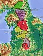
England has been divided into areas of similar landscape character. Originally called joint character areas, the national character areas are a widely recognised national spatial framework, but their boundaries are not precise and should be considered as broad zones of transition.[36]
National character areas are:
- Border Moors and Forests[37]
- Tyne Gap and Hadrian's Wall[38]
- North Pennines[39]
- Howgill Fells[40]
- Yorkshire Dales[41]
- Bowland Fells[42] the Bowland Fringe and Pendle Hill[43]
- South Pennines,[44] including the West Pennine Moors
- Dark Peak[45]
- White Peak[46]
- South West Peak[47]
History

The area contains many Bronze Age settlements, and evidence of Neolithic settlement (including many stone circles or henges, such as Long Meg and Her Daughters).[48]
The Pennines were controlled by the tribal federation of the Brigantes, made up of mainly small tribes who inhabited the area and cooperated on defence and external affairs. The Brigantes evolved an early form of kingdom. During Roman times, the Brigantes were dominated by the Romans who exploited the Pennines for their natural resources including the wild animals found there.
The Pennines were a major obstacle for Anglo-Saxon expansion westwards, although it appears the Anglo-Saxons travelled through the valleys. During the Dark Ages the Pennines were controlled by Celtic and Anglo-Saxon kingdoms. It is believed that the north Pennines were under the control of the kingdom of Rheged.
During Norse times the Pennines were settled by Viking Danes in the east and Norwegian Vikings in the west. The Vikings influenced place names, culture and genetics. When England was unified the Pennines were incorporated into it. Their mixture of Celtic, Anglo-Saxon and Viking heritage resembled much of the rest of northern England and its culture developed alongside its lowland neighbours in northwest and northeast England. The Pennines were not a distinct political polity, but were divided between neighbouring counties in northeast and northwest England; a major part was in the West Riding of Yorkshire.
Demography
The Pennine region is sparsely populated by English standards. Larger population centres adjoin the southern Pennine range and the Peak District, such as Chesterfield, Halifax, Huddersfield, Macclesfield, Oldham and Rochdale, but most of the northern Pennine range is thinly populated.[49] The cities of Bradford, Derby, Leeds, Manchester, Sheffield, Stoke-on-Trent and Wakefield lie in the foothills and lowlands fringing the range.
Economy
The main economic activities include sheep farming, quarrying, finance and tourism.
Transport

Gaps that allow west–east communication across the Pennines include the Tyne Gap between the Pennines and the Cheviots, through which the A69 road and Tyne Valley railway link Carlisle and Newcastle upon Tyne. The A66 road, its summit at 1,450 feet (440 m), follows the course of a Roman road from Scotch Corner to Penrith through the Stainmore Gap between the Eden Valley in Cumbria and Teesdale in County Durham. The Aire Gap links Lancashire and Yorkshire via the valleys of the Aire and Ribble. Other high-level roads include Buttertubs Pass, named from limestone potholes near its 1,729-foot (527 m) summit, between Hawes in Wensleydale and Swaledale and the A684 road from Sedbergh to Hawes via Garsdale Head which reaches 1,100 feet (340 m).[50]
Further south the A58 road traverses the Calder Valley between West Yorkshire and Greater Manchester reaching 1,282 feet (391 m) between Littleborough and Ripponden, while the A646 road along the Calder Valley between Burnley and Halifax reaches 764 feet (233 m) following valley floors. In the South Pennines the A628 Woodhead road links the M67 motorway in Greater Manchester with the M1 motorway in South Yorkshire and Holme Moss is crossed by the A6024 road, whose highest point is near Holme Moss transmitting station between Longdendale and Holmfirth.[50]
The Pennines are traversed by the M62 motorway, the highest motorway in England at 1,221 feet (372 m) on Windy Hill near Junction 23.[50]
Three trans-Pennine canals built during the Industrial Revolution cross the range:
- The Huddersfield Narrow Canal connects Huddersfield in the east with Manchester in the west. When it reaches Marsden, it passes underneath the hills through the Standedge Tunnel to Diggle. Fortnightly during the summer season, one can pass through the tunnel on a public narrowboat.[51]
- The Rochdale Canal crosses the Pennines via Rochdale, connecting the market town of Sowerby Bridge with Manchester.
- The Leeds and Liverpool Canal, the longest and most northerly of the three, crosses the Pennines via Skipton, Burnley, Chorley and Wigan connecting Leeds in the east with Liverpool in the west.
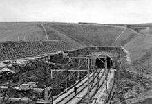
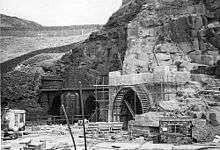
The first of the earlier twin tunnels (Woodhead 1 and 2) was completed by the Sheffield, Ashton-Under-Lyne and Manchester Railway in 1845, engineered by Charles Vignoles and Joseph Locke. At the time of its completion in 1845, Woodhead 1 was one of the world's longest railway tunnels at a length of 3 miles 13 yards (4,840 m); it was the first of several trans-Pennine tunnels including the Standedge and Totley tunnels, which are only slightly longer.
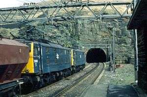
The first two tunnels were replaced by Woodhead 3, which was longer than the other two at 3 miles 66 yards (4860m). It was bored purposely for the overhead electrification of the route and completed in 1953. The tunnel was opened by the then transport minister Alan Lennox-Boyd on 3 June 1954.[52] It was designed by Sir William Halcrow & Partners. The line was closed in 1981.
The London and North Western Railway acquired the Huddersfield and Manchester Railway in 1847 and built a single-line tunnel parallel to the canal tunnel at Standedge with a length of 3 miles, 57 yards (4803 m). Today rail services along the Huddersfield line between Huddersfield and Victoria and Piccadilly stations in Manchester are operated by TransPennine Express and Northern. Between 1869 and 1876 the Midland Railway built the Settle-Carlisle Line through remote, scenic regions of the Pennines from near Settle to Carlisle passing Appleby-in-Westmorland and a number of other settlements, some a distance from their stations. The line has survived, despite difficult times[53] and is operated by Northern Rail.[54]
The Trans Pennine Trail, a long-distance route for cyclists, horse riders and walkers, runs west–east alongside rivers and canals, along disused railway tracks and through historic towns and cities from Southport to Hornsea (207 miles/333 km).[55] It crosses the north–south Pennine Way (268 miles/431 km) at Crowden-in-Longdendale.
National Parks and AONBs
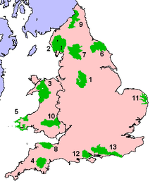
Considerable areas of Pennine landscape are protected as UK national parks and Areas of Outstanding Natural Beauty (AONBs): Northumberland National Park (9), Yorkshire Dales National Park (7) and the Peak District National Park (1) and the North Pennines AONB. Areas of Outstanding Natural Beauty are afforded much the same protection as National Parks.
The North Pennines AONB just north of the Yorkshire Dales rivals the National Park in size and includes some of the Pennines' highest peaks and some of its most isolated and sparsely populated areas. Nidderdale is an AONB east of the Yorkshire Dales National Park, and the Bowland Fells, including Pendle Hill, is an AONB west of the Yorkshire Dales.
Language
The language used in pre-Roman and Roman times was British. During the Early Middle Ages, the Cumbric language developed. However, little evidence of Cumbric remains, so it is difficult to ascertain whether or not it was a language in its own right or simply a dialect of Old Welsh. The extent of the region in which Cumbric was spoken is also unknown.
During Anglo-Saxon times the area was settled by Anglian peoples of Mercia and Northumbria, rather than the Saxon people of Southern England. Celtic speech remained in most areas of the Pennines longer than it did in the surrounding areas of England. Eventually, the Celtic tongue of the Pennines was replaced by early English as Anglo-Saxons and Vikings settled the area and assimilated the Celts.
In Norse times, Viking settlers brought their languages of Old Norse, Old Danish (mainly in the Yorkshire Dales and parts of the Peak District) and Old Norwegian (mainly in the western Pennines). With the eventual consolidation of England by the Saxon kingdom of Wessex, the pure Norse speech died out in England, though it survived in the Pennines longer than in most areas. However, the fusion of Norse and Old English was important in the formation of Middle English and hence Modern English, and many individual words of Norse descent remain in use in local dialects, such as that of Yorkshire, and in local place names.
Folklore and customs
The folklore and customs are mostly based on Celtic, Anglo-Saxon and Viking customs and folklore. Many customs and stories have their origin in Christianised pagan traditions. In the Peak District, a notable custom is well dressing, which has its origin in pagan traditions that became Christianised.
Flora
Flora in the Pennines is adapted to moorland and subarctic landscapes and climates. The flora found there can be found in other areas of moorland in Northern Europe and some species are also found in areas of tundra.
In the Pennine millstone grit areas above an altitude of 900 feet (270 m) the topsoil is so acidic, pH 2 to 4, that it can grow only bracken, heather, sphagnum, and coarse grasses[28] such as cottongrass, purple moor grass and heath rush.[56]
As the Ice age glacial sheets retreated c. 11,500 BC trees returned and archaeological palynology can identify their species. The first trees to settle were willow, birch and juniper, followed later by alder and pine. By 6500 BC temperatures were warmer and woodlands covered 90% of the dales with mostly pine, elm, lime and oak. On the limestone soils the oak was slower to colonize and pine and birch predominated. Around 3000 BC a noticeable decline in tree pollen indicates that neolithic farmers were clearing woodland to increase grazing for domestic livestock, and studies at Linton Mires and Eshton Tarn find an increase in grassland species.[57]
On poorly drained impermeable areas of millstone grit, shale or clays the topsoil gets waterlogged in winter and spring. Here tree suppression combined with the heavier rainfall results in blanket bog up to 7 ft (2 m) thick. The erosion of peat still exposes stumps of ancient trees.[57]
"In digging it away they frequently find vast fir trees, perfectly sound, and some oaks ..."
Conifers have now been widely replanted as a cheap source of wood, especially around areas such as Kielder Forest.
Fauna

Fauna in the Pennines is similar to the rest of England and Wales, but the area hosts some specialised species. Deer are found throughout the Pennines and some species of animals that are rare elsewhere in England can be found here. Arctic hares, which were common in Britain during the Ice Age and retreated to the cooler, more tundra-like uplands once the climate warmed up, were introduced to the Dark Peak area of the Peak District in the 19th century.
Large areas of heather moorland in the Pennines are managed for driven shooting of wild red grouse. The related and declining black grouse is still found in northern parts of the Pennines. Other birds whose English breeding strongholds are in the Pennines include golden plover, snipe, curlew, dunlin, merlin, short-eared owl, ring ouzel and twite,[59] though many of these are at the southern limit of their distributions and are commoner in Scotland.
See also
- Geography of England
- Geology of the United Kingdom
- Geology of Yorkshire
- North Pennines
- South Pennines
- Yorkshire Three Peaks
References
- ↑ "What are the landforms of England?". Project Britain. Retrieved 25 July 2016.
- ↑ Poucher, W.A. (1946). "The Backbone of England. A photographic and descriptive guide to the Pennine range from Derbyshire to Durham.". Guildford and Esher: Billing and Sons Limited.
- ↑ Edwards, W.; Trotter, F.M. (1975). The Pennines and Adjacent Areas. Handbooks on the Geology of Great Britain (Third ed.). London: HMSO (published 1954). p. 1. ISBN 0-11-880720-X.
- ↑ "Pennines -- Britannica Online Encyclopedia". Retrieved 28 February 2008.
- ↑ Dudley Stamp, L (1946). "Britain's Structure and Scenery". Nature. The Fontana New Naturalist Series (1960 ed.). London and Glasgow: Collins. 158 (4023): 809. Bibcode:1946Natur.158..809T. doi:10.1038/158809a0.
- ↑ "Writer inspired by beauty of Pennines celebrates its views". Yorkshire Post. Retrieved 13 October 2008.
- ↑ "Natural England - Areas of Outstanding Natural Beauty". Natural England. Retrieved 23 October 2013.
- ↑ "Natural England - National Parks". Natural England. Retrieved 2 December 2007.
- ↑ "Trail stats, Pennine Way". National Trails Homepage. The Countryside Agency. Retrieved 3 August 2007.
- ↑ Gelling, cited by Redmonds[11]
- 1 2 3 4 5 Redmonds, George (15 March 2007), "A Major Place-Name Ignored", Names and History: People, Places, and Things, London: Hambledon & London (published 2004), pp. 65–68, ISBN 1-85285-426-X
- ↑ Hussey, Arthur (1853), "A Renewed Examination of 'Richard of Cirencester'", in Cave, Edward, The Gentleman's Magazine, XXXIX, London: J.B. Nichols & Son, pp. 270–273
- ↑ Route VII: "... This province is divided into two equal parts by a chain of mountains called the Pennine Alps, which rising on the confines of the Iceni and Carnabii, near the River Trivona [Trent], extend towards the north in a continued series of fifty miles ..."[14]
- ↑ Bertram, Charles (1809) [First published in 1757], "Chapter XXXIII", The Description of Britain, Translated from Richard of Cirencester, Anonymously translated & annotated by Henry Hatcher, London: J. White & Co., p. 51
- ↑ Skipton, Camden said, was "hidden and enclosed among steep Hilles to Latium in Italie, which Varro supposeth to have been called because it lyeth close under the Apennine and the Alps". He went on to describe how "the North part ... riseth up and swelleth somewhat mountainous, with moores and hilles, but of no bignesse, which beginning here runs like as Apennine doth in Italie, through the middest of England ... even as far as Scotland, although oftentimes they change their name."
- ↑ Livy, History of Rome, Book V, §35.
- ↑ Livy, History of Rome, Book XXXI, §38.
- ↑ Falileyev, Alexander, ed. (2007). "Summus P(o)eninus" (pdf). Dictionary of Continental Celtic Place-Names. Aberystwyth University. Retrieved 2 May 2009.
- ↑ Lewis, Charlton T.; Short, Charles (1879). "Apenninus". A Latin Dictionary. Oxford; Medford: Clarendon Press; Perseus Digital Library. Retrieved 23 October 2013.
- ↑ Deecke 1904, p. 23
- ↑ "unknown".
- ↑ R. Matasović (2009): Etymological Dictionary of Proto-Celtic. Leiden-Boston: Brill. [ISBN 978-90-04-17336-1]
- ↑ Gunn, Peter (1984). The Yorkshire Dales. Landscape with Figures. London: Century Publishing Co Ltd. ISBN 0-7126-0370-0.
- ↑ "30 Southern Magnesian Limestone". Natural England. 18 July 2013. Retrieved 7 February 2015.
- ↑ "48: Trent and Belvoir Vales". Natural England. 8 April 2013. Retrieved 7 February 2015.
- ↑ "68. Needwood & South Derbyshire Claylands". Natural England. 3 January 2013. Retrieved 7 February 2015.
- ↑ "69 Trent Valley Washlands". Natural England. 3 September 2013. Retrieved 7 February 2015.
- 1 2 page 4 and page 5, Marginal Upland Grazing Sutton Moor, Domesday Reloaded, BBC 1986
- ↑ "Landscape". Peak District National Park. Retrieved 22 July 2016.
- ↑ "South West Peak". Peak District National Park. Retrieved 22 July 2016.
- ↑ "About the South Pennines". Retrieved 22 July 2016.
- ↑ "The Landscape of The Forest of Bowland Area Of Outstanding Natural Beauty (AONB)". Lancashire County Council. 6 June 2007. Archived from the original on 7 February 2009. Retrieved 7 December 2007.
- ↑ "Landscape". Yorkshire Dales National Park. Retrieved 22 July 2016.
- ↑ "North Pennines". Scottish Natural Heritage. Retrieved 22 July 2016.
- ↑ "Great Dun Fell 2 Climatic Averages 1981–2010". Met Office. Retrieved 22 December 2012.
- ↑ "National Character Areas". Natural England. Retrieved 10 December 2009.
- ↑ "5 Border Moors and Forests". Natural England. Retrieved 5 August 2011.
- ↑ "11 Tyne Gap and Hadrian's Wall". Natural England. Retrieved 5 August 2011.
- ↑ "10 North Pennines". Natural England. Retrieved 5 August 2011.
- ↑ "18 Howgill Fells". Natural England. Retrieved 5 August 2011.
- ↑ "21 Yorkshire Dales". Natural England. Retrieved 5 August 2011.
- ↑ "34 Bowland Fells". Natural England. Retrieved 5 August 2011.
- ↑ "33 Bowland Fringe and Pendle Hill". Natural England. Retrieved 5 August 2011.
- ↑ "36 Southern Pennines". Natural England. Retrieved 5 August 2011.
- ↑ "51 Dark Peak". Natural England. Retrieved 5 August 2011.
- ↑ "52 White Peak". Natural England. Retrieved 5 August 2011.
- ↑ "53 South West Peak". Natural England. Retrieved 5 August 2011.
- ↑ "A landscape through time". Out of Oblivion. Retrieved 5 August 2011.
- ↑ "North Pennines". My Pennines. Retrieved 15 April 2016.
- 1 2 3 Transpennine Crossings, Sabre roads, retrieved 14 August 2013
- ↑ "Standedge Tunnel & Visitor Centre: Opening times and prices". Canal and River Trust. Retrieved 15 August 2013.
- ↑ "The Woodhead Route". Railways of Britain. Retrieved 27 January 2008.
- ↑ History, settle-carlisle.co.uk, retrieved 15 August 2013
- ↑ Trains, settle-carlisle.co.uk, retrieved 15 August 2013
- ↑ Welcome to the Trans Pennine Trail, transpenninetrail.org.uk, retrieved 14 August 2013
- ↑ Kelsall, Dennis; Kelsall, Jan (2008). The Yorkshire Dales: South and West. Milnthorpe: Cicerone. p. 26. ISBN 978-1-85284-485-1.
- 1 2 White, Robert (2005) [1997]. The Yorkshire Dales, A landscape Through Time (new ed.). Ilkley, Yorkshire: Great Northern Books. ISBN 1-905080-05-0.
- ↑ Arthur Young (1771) A Six Months' Tour of the North of England
- ↑ Gibbons; et al. (1993). The New Atlas of Breeding Birds in Britain and Ireland: 1998–1991. T & A D Poyser. ISBN 0-85661-075-5.
External links
| Wikimedia Commons has media related to Pennines (hills). |
- The Pennine Edge Forest Network
- Pennine Prospects
-
 "Pennine Chain". Encyclopædia Britannica (11th ed.). 1911.