Bryantsville, Kentucky
| Bryantsville | |
|---|---|
| Unincorporated community | |
 Bryantsville  Bryantsville Location within the state of Kentucky | |
| Coordinates: 37°42′52″N 84°38′57″W / 37.71444°N 84.64917°WCoordinates: 37°42′52″N 84°38′57″W / 37.71444°N 84.64917°W | |
| Country | United States |
| State | Kentucky |
| County | Garrard |
| Elevation | 942 ft (287 m) |
| Time zone | Eastern (EST) (UTC-5) |
| • Summer (DST) | EDT (UTC-4) |
| ZIP codes | 40410 |
| GNIS feature ID | 488178 |
Bryantsville is an unincorporated community in Garrard County, Kentucky, United States. It lies along U.S. Route 27 northwest of the city of Lancaster, the county seat of Garrard County.[1] Its elevation is 942 feet (287 m).[2] Although it is unincorporated, it has a post office, with the ZIP code of 40410.[3]
Education
Bryantsville is served by Garrard County Public Schools.[4]
Notable people
- W. W. Burnside, Louisiana politician and planter
References
- ↑ Rand McNally. The Road Atlas '06. Chicago: Rand McNally, 2006, p. 43.
- ↑ U.S. Geological Survey Geographic Names Information System: Bryantsville, Kentucky, Geographic Names Information System, 1979-09-20. Accessed 2008-01-03.
- ↑ Zip Code Lookup Archived May 17, 2011, at the Wayback Machine.
- ↑ Education, Kentucky Department of. "County & Independent School Districts" (PDF). Archived from the original (PDF) on 2010-01-10. Retrieved 2010-04-04.
Municipalities and communities of Garrard County, Kentucky, United States | ||
|---|---|---|
| City | 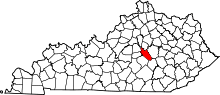 | |
| Unincorporated communities | ||
This article is issued from Wikipedia - version of the 11/18/2016. The text is available under the Creative Commons Attribution/Share Alike but additional terms may apply for the media files.