Buckeye Crossroads, Colorado
| Buckeye Crossroads, Colorado | |
|---|---|
| Unincorporated community | |
| Coordinates: 38°46′39″N 106°29′32″W / 38.77750°N 106.49222°WCoordinates: 38°46′39″N 106°29′32″W / 38.77750°N 106.49222°W | |
| Country |
|
| State |
|
| Counties | Baca[1] |
| Elevation | 3,405 ft (1,038 m) |
| Time zone | MST (UTC-7) |
| • Summer (DST) | MDT (UTC-6) |
Buckeye Crossroads is a small unincorporated community in extreme eastern Baca County, Colorado, United States.[1] The small community is located at the intersection of SH 89 and SH 116. Closely resembles Punkin Center, about 170 miles to the northwest. The population of Buckeye Crossroads was only 7 in 2000, and remains isolated, located many miles in every direction from any other town.
Geography
Buckeye Crossroads is located at 37°33′27″N 102°07′43″W / 37.55750°N 102.12861°W (37.55775,-102.11035).[1]
References
- 1 2 3 "US Board on Geographic Names". United States Geological Survey. 2007-10-25. Retrieved 2008-01-31.
Municipalities and communities of Baca County, Colorado, United States | ||
|---|---|---|
| Towns | 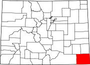 | |
| Unincorporated communities | ||
This article is issued from Wikipedia - version of the 8/11/2015. The text is available under the Creative Commons Attribution/Share Alike but additional terms may apply for the media files.