Bull Run (Occoquan River)
| Bull Run | |
|---|---|
|
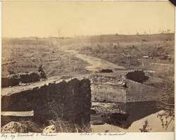
The ruins of the stone bridge over Bull Run, after the Second Battle of Bull Run, 1862, photographer unknown, from the National Archives and Records Administration | |
| Country | United States |
| Location | Fairfax Loudoun, and Prince William counties, Virginia |
| Basin | |
| River mouth | Occoquan River |
| Physical characteristics | |
| Length | 32.8 miles (52.8 km) |
Bull Run is a 32.8-mile-long (52.8 km)[1] free-flowing tributary stream of the Potomac River that originates from a spring in the Bull Run Mountains in Loudoun County, Virginia, and flows south to the Occoquan River. Bull Run serves as the boundary between Loudoun County and Prince William County, and between Fairfax County and Prince William County.
Bull Run is primarily associated with two battles of the American Civil War: the First Battle of Bull Run and the Second Battle of Bull Run. A narrow part of the creek called Yates Ford (near Manassas) is the scene of the Battle of Occoquan, and downstream about one mile is the current Yates Ford Road bridge between Fairfax and Prince William counties.
See also
References
- ↑ U.S. Geological Survey. National Hydrography Dataset high-resolution flowline data. The National Map Archived 2012-04-05 at WebCite, accessed August 15, 2011
External links
- Occoquan Watershed Monitoring Laboratory (Virginia)
- Northern Virginia Regional Commission, Occoquan Basin Nonpoint Pollution Management Program (Virginia)
- Prince William Conservation Alliance
- The Potomac Appalachian Trail Club -- Bull Run/Occoquan Trail (Virginia)
Coordinates: 38°48′33.6″N 77°29′22.4″W / 38.809333°N 77.489556°W