Bundaberg North, Queensland
| Bundaberg North Bundaberg, Queensland | |||||||||||||
|---|---|---|---|---|---|---|---|---|---|---|---|---|---|
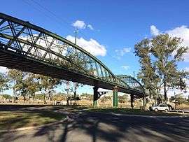 Lions Park North under Burnett Bridge | |||||||||||||
| Population | 5,484 (2011)[1] | ||||||||||||
| Postcode(s) | 4670 | ||||||||||||
| Location | 1 km (1 mi) N of Bundaberg | ||||||||||||
| LGA(s) | Bundaberg Regional Council | ||||||||||||
| State electorate(s) | Bundaberg | ||||||||||||
| Federal Division(s) | Hinkler | ||||||||||||
| |||||||||||||
Bundaberg North is a suburb of the Queensland city of Bundaberg, Queensland, Australia. It occupies the developed area north of the Burnett River, opposite the CBD. At the 2011 Census, Bundaberg North had a population of 5,485.
Geography
Bundaberg North adjoins the CBD and the suburbs of Bundaberg West, Bundaberg East and Kalkie at the Burnett River to the south and southeast, Gooburrum to the north and Oakwood to the west.
Bundaberg North is a residential suburb with some light industry and sugarcane farmlands.
The Hinkler Aviation Museum and Botanic Gardens are located in the suburb. The Millaquin sugar mill, operated by Bundaberg Sugar is a major employer in Bundaberg North.
Heritage listings
Bundaberg North has a number of heritage-listed sites, including:
- Perry Street: Burnett Bridge[2]
- Thornhill Street: Fairymead House[3]
Demographics
In Bundaberg North 81.4% people were born in Australia. The most common countries of birth were 3.7% England, 1.7% New Zealand, 0.7% Philippines, 0.6% Germany, 0.5% Scotland, 0.3% Netherlands, 0.3% South Africa, 0.3% China.
90.6% people speak English only. Other languages spoken at home were 0.4% German, 0.3% Mandarin, 0.3% Turkish, 0.3% Italian.
Commerce
Perry Street, Queen Street and Gavin Street are the two main activity centres in Bundaberg North, comprising small scale shopping strips, a pub, with a small shopping centre (in Gavin Street).
Parkway Shopping Plaza located at the intersection of Queen Street and Mt Perry Road, is the only standard shopping centre serving northern suburbs of Bundaberg city. It hosts the IGA Supermarket and Bundaberg North post office.
North Bundaberg is also home to four hostels for backpackers and two pubs (Globe Hotel and Young Australian Hotel). The only cafe in the suburb, Oodies, has recently become a hit among locals.
Parks and open space
Bundaberg Botanic Gardens sprawl over 27 hectares of land and feature a variety of 10,000 trees and shrubs. A magnificent lake, creating a habitat attracting up to 114 species of birds, is centrepiece of the Botanic Gardens, while a wedding chapel, shaded picnic areas, themed boardwalks, Japanese gardens and children’s playground enhance the appeal of one of Bundaberg’s favourite lifestyle precincts.[4]
The parklands along the river, comprising Edina St Park and Lions North Park, form the largest riverside parklands in Bundaberg. The park features some BBQ facilities and two boat ramps. Several smaller reserves are distributed evenly through the residential area.
There are two main sports facilities in the suburb : the Bundaberg Golf Course and the Hockey Ground.
Education
Primary education is provided by two schools : North Bundaberg Primary School and Bundaberg Seventh-Day Adventist Primary School.
Bundaberg State High School is the last remaining school, serving the northern suburbs of Bundaberg.
Transport
Major roads include Hinkler Avenue (State Route 3), Queen Street and Ferrymead Road.
Bundaberg North is serviced by two bus routes:
- Route 3B : City to North Bundaberg via Botanical Gardens, RSL Village and Golf Club
- Route 6 : City to Moore Park Beach
References
- ↑ Australian Bureau of Statistics (31 October 2012). "Bundaberg North (State Suburb)". 2011 Census QuickStats. Retrieved 7 February 2014.
- ↑ "Burnett Bridge (entry 600368)". Queensland Heritage Register. Queensland Heritage Council. Retrieved 7 July 2013.
- ↑ "Fairymead House (entry 601009)". Queensland Heritage Register. Queensland Heritage Council. Retrieved 7 July 2013.
- ↑ "Botanic Gardens Attractions | Bundaberg Regional Council". www.bundaberg.qld.gov.au. Retrieved 2015-10-03.
External links
![]() Media related to Bundaberg North, Queensland at Wikimedia Commons
Media related to Bundaberg North, Queensland at Wikimedia Commons
- "Bundaberg suburbs". Queensland Places. Centre for the Government of Queensland, University of Queensland.
Coordinates: 24°51′02″S 152°20′30″E / 24.850627°S 152.341722°E