Ravenna, Seattle
| Ravenna | |
|---|---|
| Seattle Neighborhood | |
|
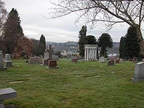
Calvary Cemetery in Ravenna/Bryant with University of Washington residence towers in background. | |
 Map of Ravenna's location in Seattle |
Ravenna is a neighborhood in northeastern Seattle, Washington named after Ravenna, Italy. Though Ravenna is considered a residential neighborhood, it also is home to several businesses, many of which are located in the University Village, a shopping mall.
Ravenna-Cowen Park, located near University Village and the walking or biking route connecting Green Lake to Burke-Gilman Trail, is a popular feature of the neighborhood.[1]
Ravenna and Ravenna-Bryant
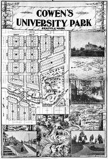
What is now Ravenna has been inhabited since the end of the last glacial period (c. 8000 BCE—10,000 years ago). The Native American Duwamish (before contact, the Dkhw’Duw’Absh, "the People of the Inside") tribe of the Lushootseed (Skagit-Nisqually) Coast Salish nations had the prominent village of SWAH-tsoo-gweel ("portage") on then-adjacent Union Bay, and what is now Ravenna was their backyard before the arrival of White settlers.[2] The Seattle, Lake Shore and Eastern Railway was built c. 1886 along what is now the Burke-Gilman Trail, following what was the shoreline past where the UW power plant and University Village are today.[3] In 1891, a streetcar line followed 14th Avenue NE (what is now University Way NE, as illustrated in the Cowen's University Park Addition Seattle annex map below on this page), then followed near the southern boundary of what is now Ravenna Park, where the narrow right-of-way remains clearly visible beside the park. Ravenna Boulevard was built in 1903 as a small part of the Olmsted Brothers' grand plan for Seattle streets and parks.[4] Ravenna incorporated as an independent town in 1906, which permitted Seattle to annex it in 1907.[5] The original boundary of the Town of Ravenna when it was annexed extended from 15th Avenue NE eastward to 20th Avenue NE (above 65th Street NE) and eastward to 30th Ave NE (south of 65th Street NE), bounded on the south by 55th Street.[6] Ravenna south of the Burke-Gilman Trail is filled land from dump sites at 26th Avenue, filling the drained Union Bay Marsh and much of Union Bay.[7] University Village (1956) was built on the southernmost reclaimed land in Ravenna.[8]
Ravenna is bounded on the west by 15th and 20th Avenues NE, beyond which lies the Roosevelt neighborhood; on the north by NE 75th and 85th Streets, beyond which lie Maple Leaf and Wedgwood; on the east by 35th and 25th Avenues NE, beyond which lie View Ridge, Windermere and Laurelhurst;[9][10] and on the south by NE Ravenna Boulevard, and NE Blakeley or NE 45th Streets, beyond which lie the University District and sometimes University Village (boundaries are informal). University Village and Calvary Cemetery are in south Ravenna.[11]
The adjacent Bryant neighborhood, or Ravenna-Bryant, extends the neighborhood east to 45th Avenue NE, south of NE 75th Street and north of Sand Point Way NE.[10]
The principal arterial is 25th Avenue NE; minor arterials are 15th and 35th Avenues NE, and NE 65th Street; 40th Avenue NE and NE 55th Street are collector arterials.[12] Besides the eponymous boulevard, arguably its most well-known street is Candy Cane Lane. On the length of Park Road (one block and a little roundabout) residents have been creating an elaborate Christmas display since 1951, bringing bumper-to-bumper traffic to the boulevard on December nights.[13] The 20th Avenue NE collector arterial has become increasingly bike- and pedestrian-friendly with the closure of the park bridge to motor vehicles (1975).[14] NE Ravenna Boulevard is a popular bikeway.
An eponymous grocery has been at the same location on the boulevard since the 1920s.[15] Most emblematic of the neighborhood are Queen Mary, serving Victorian English Tea, and the Duchess Tavern (1934). The only Volvo dealership in town is family-owned and in Ravenna-Bryant.[16]
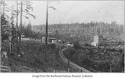
The accompanying photograph shows an area around the railroad depot in the late 19th century. Between the depot and the mill could now be 25th Avenue NE at the Burke-Gilman Trail. Left of the mill is the Ravenna Depot, center. The straight road left continues past Roper's Grocery on 24th Street, just left of the tree, left of center, to what is now the SE corner of Ravenna Park, behind the house between the foreground trees. Behind the hamlet of Ravenna, middle background, is the new Seattle Female College (c. 1890), "non-sectarian, distinctly Christian", and including the Seattle Conservatory of Music and Ravenna Seminary. The stable for the college is beyond the depot. Left of the college and above the small foreground snag, faintly, is a broad side of the Phillips house, still extant today.[17]
Ravenna-Cowen Park
The conjoined Cowen Park and Ravenna Park is located at a southwest corner of Ravenna-Bryant, reaching from beyond the source of Ravenna Creek beside nearby Brooklyn Avenue and Ravenna Boulevard, under the 15th Avenue bridge to 25th Avenue NE. The parks comprise the centerpiece of the neighborhood.
For many decades of Seattle city history, the park ravine had been ignored by loggers and farmers and still possessed full old-growth timber rising nearly 400 feet.[18] The trees remained through the Alaska-Yukon-Pacific Exposition of 1908, at which they were featured exhibitions. Public controversy about them declined after their gradual disappearance in suspicious circumstances by 1926.[19] Today, none of that size remain anywhere in the world.[20] The legacy helped save Seward and Carkeek parks, and helped galvanize conservation efforts ever since.[21] Today, a single Sierra Redwood stands over the Medicinal Herb Garden at a south edge of the UW campus, at 106 feet somewhat over a quarter of the height of those of Cowen Park-Ravenna Park.[22][23]
Ravenna Creek
Projects have included daylighting portions of the creek (partly with the goal of restoring native fish runs), building and maintaining trails, and restoring riparian habitat, sometimes in collaboration with the University of Washington's environmental science program.[24][25][26] Completion of downstream daylighting to the mouth of the creek beside Union Bay Natural Area and restoration of migrating fish has come into conflict with property owners, specifically the owners of University Village, even though a revised daylighting project would not include their land.[27]
See also
References
- ↑ "Seattle's Urban Trail System, January 2004". Seattle DOT Bicycle Program. Seattle Department of Transportation. 2005. Archived from the original on 2006-03-16. Retrieved 2006-04-21.
- ↑ Dailey, 26, ref. 2, 8)
- ↑ Phelps (1978), p. 25
- ↑ "Olmsted Park Plans Cybertour". Point 1 of 21. HistoryLink.org. April 2003. Retrieved 2006-04-21.
- ↑ Wilma (2001-08-20, Essay 3502)
- ↑ http://www.historylink.org/index.cfm?DisplayPage=output.cfm&file_id=3315 http://www.seattle.gov/cityarchives/exhibits-and-education/online-exhibits/annexed-cities
- ↑ (1) Marsh drained 1916 with the opening of the Montlake Cut of the Lake Washington Ship Canal. Fill sites 1911, 1920, 1926; last acreage in the University District closed 1966 or 1967).
(1.1) Phelps (1978), pp. 208, 210; "HISTORY @UBNA", next.
(1.2) "HISTORY @ UBNA". Center for Urban Horticulture, Departments of the University of Washington. n.d., 1999 per "Montlake Landfill Information SumMarchy, January 1999" on page. Retrieved 2006-04-21. Check date values in:|date=(help) - ↑ Dorpat (2001-06-18, Essay 3380)
- ↑ (1)
"Area 4". Seattle City Clerk's Neighborhood Map Atlas. Office of the Seattle City Clerk. 2002-06-17. Retrieved 2006-04-21.
(2) "Ravenna". Seattle City Clerk's Neighborhood Map Atlas. Office of the Seattle City Clerk. Retrieved 2006-04-21. - 1 2 "Bryant". Seattle City Clerk's Neighborhood Map Atlas. Office of the Seattle City Clerk. 2002-06-17. Retrieved 2006-04-21.
- ↑ (1) "Ravenna". Seattle City Clerk's Neighborhood Map Atlas. Office of the Seattle City Clerk. Retrieved 2006-04-21. (2) "About the Seattle City Clerk's On-line Information Services". Information Services. Seattle City Clerk's Office. 2006-04-30. Retrieved 2006-05-21.
- ↑ "Street Classification Maps". Seattle Department of Transportation. 2005. Retrieved 2006-04-21.
- ↑ Hook (2000-11-23)
- ↑ (1) Engineering Department, Traffic and Transportation Division, Study : 20th Avenue N.E. bridge closure. Seattle, WA: The Dept. [sic], 1975.
(2) Higgins (1999-07-30) "Traffic" - ↑ Lund (2006-03-15)
- ↑ Higgins (1997-12-06) "Area"
- ↑ (1) Dorpat (1994), ch. 42
(2) Dorpat (1981), images 104-U, 105-U, 106-U, 107-U - ↑ (1)
Wilma (2001-08-20), Essay 3502
(1.1) See also list of newspaper articles referenced by Wilma
(2) Dolan & True (2003), pp. 142–143.
(3) Van Pelt (2001), pp. xxii, 181–185, 187–191. - ↑ Williams, David B. (2010-03-31). "Seattle Parks Department cuts down huge Ravenna Park trees in the mid-1920s". HistoryLink.org.
- ↑ (1)
Wilma (2001-08-20), Essay 3502
(1.1) See also list of newspaper articles referenced by Wilma
(2) Higgins (1999-07-30), "Traffic"
(3) Van Pelt (2001) - ↑ Dolan & True (2003), p. 142
- ↑ (1) Located at an edge of the central main campus, SSW of Drumheller Fountain near Stevens Way. (2) Dolan & True (2003), p. 144.
- ↑ "Chronology". Ravenna Creek Alliance. August 1998. Retrieved 2006-04-21.
- ↑ http://depts.washington.edu/uwren/
- ↑ (1) Dolan & True (2003)
(2) O'Neil (1998)
(3) "Chronology". Ravenna Creek Alliance. August 1998. Retrieved 2006-04-21.
(4) Whittemore (n.d.) - ↑ "Ravenna Creek Alliance: Specific Info". Ravenna Creek Alliance. 2005-11-09. Retrieved 2006-04-21.
- ↑ (1) Higgins (1997-12-06) "Residents"
(2) O'Neil (1998)
(3) "Ravenna Creek Alliance: Specific Info". Ravenna Creek Alliance. 2005-11-09. Retrieved 2006-04-21.
External links
Bibliography
- Dorpat, Paul (1981). 294 glimpses of historic Seattle, its neighborhoods and neighborhood businesses. Seattle: P. Dorpat c/o The Mayor's Small Business Task Force.
- "About the Seattle City Clerk's On-line Information Services". Information Services. Seattle City Clerk's Office. 2006-04-30. Retrieved 2006-05-21.
See heading, "Note about limitations of these data". - "Area 4". Seattle City Clerk's Neighborhood Map Atlas. Office of the Seattle City Clerk. n.d., map .jpg c. 2002-06-17. Retrieved 2006-04-21. Check date values in:
|date=(help) - "Bryant". Seattle City Clerk's Neighborhood Map Atlas. Office of the Seattle City Clerk. n.d., map .jpg c. 2002-06-17. Retrieved 2006-04-21. Check date values in:
|date=(help)
Note caveat in footer.
Maps "NN-1030S", "NN-1040S".jpg dated 17 June 2002. - "Chronology". Ravenna Creek Alliance. n.d., August 1998 per Chronology. Retrieved 2006-04-21. Check date values in:
|date=(help) - "Cover map". "Seattle History: Maps" in "150 Years: Seattle By and By". The Seattle Times. n.d., 2001 by sesquicentennial. Archived from the original on 2006-04-07. Retrieved 2006-04-21. Check date values in:
|date=(help)
The landscape carved by the Vashon Glacier some 14,000 years ago. - Dailey, Tom (n.d.). "Duwamish-Seattle". "Coast Salish Villages of Puget Sound". Retrieved 2006-04-21. External link in
|work=(help)
Page links to Village Descriptions Duwamish-Seattle section.
Dailey referenced "Puget Sound Geography" by T. T. Waterman. Washington DC: National Anthropological Archives, mss. [n.d.] [ref. 2];
Duwamish et al. vs. United States of America, F-275. Washington DC: US Court of Claims, 1927. [ref. 5];
"Indian Lake Washington" by David Buerge in the Seattle Weekly, 1–7 August 1984 [ref. 8];
"Seattle Before Seattle" by David Buerge in the Seattle Weekly, 17–23 December 1980. [ref. 9];
The Puyallup-Nisqually by Marian W. Smith. New York: Columbia University Press, 1940. [ref. 10].
Recommended start is "Coast Salish Villages of Puget Sound" - Dolan, Maria & True, Kathryn (2003). Nature in the city: Seattle. Seattle: Mountaineers Books, pp. 142–143. ISBN 0-89886-879-3 (paperback).
- Engineering Department, Traffic and Transportation Division, Study : 20th Avenue N.E. bridge closure. Seattle, WA: The Dept. [sic], 1975.
- Dorpat, Paul (1994). "ch. 42". Seattle, now & then (2d edition of vol. I of III). Seattle: Tartu Publications. ISBN 0-9614357-0-4, ISBN 0-9614357-1-2 (pbk.).
- Dorpat, Paul (18 June 2001, updated May 2002). "Seattle Neighborhoods: University District -- Thumbnail History". HistoryLink.org Essay 3380. Retrieved 2006-04-21. Check date values in:
|date=(help)
Dorpat referenced Seattle: Now and Then Vols. 1, 2, and 3. Seattle: Tartu Publications, 1984, 1988);
Walt Crowley and Paul Dorpat, "The Ave: Streetcars to Street Fairs", typescript dated 1995 in possession of Walt Crowley and Paul Dorpat, Seattle, Washington;
Walt Crowley, Rites of Passage. Seattle: University of Washington Press, 1995;
Cal McCune, From Romance to Riot: A Seattle Memoir. Seattle: Cal McCune, 1996;
Roy Nielsen, UniverCity: The City Within City: The Story of the University District Seattle: University Lions Foundation, ca. 1986;
Clark Humphrey, Loser: the Real Seattle Music Story. Portland, OR: Feral House, 1995. - Hadley, Jane (1986-06-12). "Protest Nearly Buries Storm-Water Project: A Ravenna Park Pipeline Probably Won't Be Built". Section: News. Seattle Post-Intelligencer. p. A9. Retrieved 2006-04-21.
- Heather (August 2001). "Tea Time". "On the Tea Table". Georgian Index. Retrieved 2006-04-21.
- Higgins, Mark (1997-12-06). "Area is quintessential Seattle". "Neighbors: Ravenna". Seattle Post-Intelligencer. Retrieved 2006-04-21.
Updated at "From middle-class houses to mansions". Seattle Post-Intelligencer. n.d. Retrieved 2006-04-21.
"The Neighbors project was published weekly in the Seattle Post-Intelligencer from 1996 to 2000. This page remains available for archival purposes only and the information it contains may be outdated. For more updated information, please visit our Webtowns section." - Higgins, Mark (1999-07-30). "Traffic wars just latest fight for activist neighborhood". Neighbors project. Seattle Post-Intelligencer. Retrieved 2006-05-21.
- Higgins, Mark (1997-12-06). "Residents rally to save creek". Neighbors project. Seattle Post-Intelligencer. Retrieved 2006-04-21.
- HistoryLink with Friends of Seattle's Olmsted Parks; McCaffery, Marie, map art (c. April 2003). "Olmsted Park Plans Cybertour". Point 1 of 21. HistoryLink.org. Retrieved 2006-04-21. Cite uses deprecated parameter
|coauthors=(help); Check date values in:|date=(help) - "HISTORY @ UBNA". Center for Urban Horticulture, Departments of the University of Washington. n.d., 1999 per "Montlake Landfill Information SumMarchy, January 1999" on page. Retrieved 2006-04-21. Check date values in:
|date=(help) - Hook, Jamie (2000-11-23). "Obsession & Lights, True Story of". The Stranger. Retrieved 2006-04-21.
- Lund, Abby (2006-03-15). "Not just another neighborhood grocery store - Boulevard Grocery finds its niche after decades in Ravenna". North Seattle Herald-Outlook. Retrieved 2006-04-21.
- O'Neil, Kit (n.d., (August 1998 per Chronology). "Ravenna Creek Daylighting Project". University Community Urban Center. Retrieved 2006-04-21. Check date values in:
|date=(help) - Paajanen, Sean (n.d.). "High Tea vs. Afternoon Tea". Coffee / Tea. About, Inc., a part of The New York Times Company. Retrieved 2006-04-21.
- Phelps, Myra L. (1978). Public works in Seattle. Seattle: Seattle Engineering Department. ISBN 0-9601928-1-6.
- "Planned Arterials Map Legend Definitions" (PDF). "City of Seattle Street Classification Maps". City of Seattle Department of Transportation. 2004-01-12. Retrieved 2006-04-21. External link in
|work=(help)
See also pdf note. - "Street Classification Maps". Seattle Department of Transportation. 2005. Retrieved 2006-04-21.
High-Resolution Version, PDF format, 16.1 MB
Medium-Resolution Version, PDF format, 1.45 MB 12 January 2004.
Low-Resolution Version, PDF format, 825 KB 12 January 2004.
"Planned Arterials Map Legend Definitions", PDF format. 12 January 2004.
The high resolution version is good for printing, 11 x 17. The low and medium resolution versions are good for quicker online viewing. [Source: "Street Classification Maps, Note on Accessing These PDF Files"] - "Ravenna". Seattle City Clerk's Neighborhood Map Atlas. Office of the Seattle City Clerk. n.d., map .jpg c. 2002-06-17. Retrieved 2006-04-21. Check date values in:
|date=(help)
Note caveat in footer.
Maps "NN-1030S", "NN-1040S".jpg dated 17 June 2002. - "Ravenna Creek Alliance: Specific Info". Ravenna Creek Alliance. 2005-11-09. Retrieved 2006-04-21.
- "Seattle's Urban Trail System, January 2004". Seattle DOT Bicycle Program. Seattle Department of Transportation. 2005. Archived from the original on 2006-03-16. Retrieved 2006-04-21.
- Van Pelt, Robert (2001). Forest giants of the Pacific Coast. Vancouver and San Francisco: Global Forest Society in association with University of Washington Press. pp. xxii, 181–185, 187–191. ISBN 0-295-98140-7.
- Whittemore, Thomas (n.d.). "Measure water quality parameters". Science Service Learning. University of Washington Chemistry Department. Retrieved 2006-04-21.
- Wilma, David (2001-08-20). "Seattle Neighborhoods: Ravenna - Roosevelt -- Thumbnail History". "HistoryLink.org Essay 3502". Retrieved 2006-04-21.
Wilma referenced "Calvary Cemetery", Historylink Metropedia Library (www.Historylink.org);
"Ravenna Post Office", Historylink Timeline Library (www.Historylink.org);
"City of Seattle Annexes Town of Ravenna", Ibid.;
"Methodists Form Congregation in Ravenna Neighborhood", Ibid.;
"University District", Historylink Magic Lantern Library (www.Historylink.org);
Keming Kuo, "Beautiful Trees Cut To 'Line Someone's Pocket'", The Seattle Times, 29 June 1977;
"Removal of Trees Protested", Ibid., 23 November 1926;
"Removal of Giant Trees Would Be Crime", Ibid., 4 November 1926;
"Roosevelt Park Again Ravenna", ibid., 29 May 1931;
"Sears To Close Roosevelt Store", > Ibid., 1 November 1979;
Shareen Singh, "Area's Metaphysical Bent Is Well Known", Seattle Post-Intelligencer, 12 September 1998, Neighbors (project 1996-2000);
Margaret Pitcairn Strachan, "Roosevelt-Ravenna Are Bustling Areas", The Seattle Sunday Times, 7 July 1946, p. 5;
Seattle School Histories, 1869-1974 ed. by Sara Levant (Seattle: Seattle Public Schools, 1974).
Further reading
- "Aerial Photo". Ravenna Creek Alliance. n.d., .jpg dated 2001-12-16. Retrieved 2006-04-21. Check date values in:
|date=(help)
Image of Ravenna Park and the greater University District to Union Bay-Portage Bay. - Salisbury, Chukundi (2005-05-11). "Ravenna & Cowen Parks Trails". The Trails Program Trail Maps. Seattle Department of Parks and Recreation. Retrieved 2006-04-21.
- Walter, Sunny; local Audubon chapters (2006-02-10). "Sunny Walter's Washington Nature Weekends: Wildlife Viewing Locations - Greater Seattle Area". Retrieved 2006-04-21.
"with additions by Sunny Walter and local Audubon chapters."
Viewing locations only; the book has walks, hikes, wildlife, and natural wonders.
Walter excerpted from- Dolan, Maria; True, Kathryn (2003). Nature in the city: Seattle. Seattle: Mountaineers Books. ISBN 0-89886-879-3 (paperback).
See "Northeast Seattle" section. Particularly useful.
- Dolan, Maria; True, Kathryn (2003). Nature in the city: Seattle. Seattle: Mountaineers Books. ISBN 0-89886-879-3 (paperback).
Coordinates: 47°40′35″N 122°18′07″W / 47.67639°N 122.30194°W