Burlington Township, Coffey County, Kansas
| Burlington Township | |
|---|---|
| Township | |
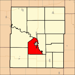 Location in Coffey County | |
| Coordinates: 38°10′13″N 095°46′31″W / 38.17028°N 95.77528°WCoordinates: 38°10′13″N 095°46′31″W / 38.17028°N 95.77528°W | |
| Country | United States |
| State | Kansas |
| County | Coffey |
| Area | |
| • Total | 31.35 sq mi (81.2 km2) |
| • Land | 31.2 sq mi (80.82 km2) |
| • Water | 0.15 sq mi (0.39 km2) 0.48% |
| Elevation | 1,076 ft (328 m) |
| Population (2000) | |
| • Total | 300 |
| • Density | 9.6/sq mi (3.7/km2) |
| GNIS feature ID | 0477862 |
Burlington Township is a township in Coffey County, Kansas, United States. As of the 2000 census, its population was 300.
Geography
Burlington Township covers an area of 31.35 square miles (81.2 km2) and contains one incorporated settlement, Burlington (the county seat). According to the USGS, it contains four cemeteries: Calvary, Cola Hill, Graceland and Mount Hope.
The stream of Rock Creek runs through this township.
References
External links
Municipalities and communities of Coffey County, Kansas, United States | ||
|---|---|---|
| Cities | 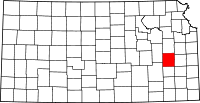 | |
| Unincorporated communities |
| |
| Townships | ||
This article is issued from Wikipedia - version of the 11/11/2016. The text is available under the Creative Commons Attribution/Share Alike but additional terms may apply for the media files.