Bussière-Poitevine
| Bussière-Poitevine | ||
|---|---|---|
|
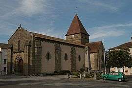
The church of Saint-Maurice, in Bussière-Poitevine | ||
| ||
 Bussière-Poitevine | ||
|
Location within Nouvelle-Aquitaine region  Bussière-Poitevine | ||
| Coordinates: 46°14′11″N 0°54′20″E / 46.2364°N 0.9056°ECoordinates: 46°14′11″N 0°54′20″E / 46.2364°N 0.9056°E | ||
| Country | France | |
| Region | Nouvelle-Aquitaine | |
| Department | Haute-Vienne | |
| Arrondissement | Bellac | |
| Canton | Mézières-sur-Issoire | |
| Intercommunality | Haut Limousin | |
| Government | ||
| • Mayor (2008–2014) | Andre Dubois | |
| Area1 | 41.71 km2 (16.10 sq mi) | |
| Population (2006)2 | 980 | |
| • Density | 23/km2 (61/sq mi) | |
| Time zone | CET (UTC+1) | |
| • Summer (DST) | CEST (UTC+2) | |
| INSEE/Postal code | 87028 / 87320 | |
| Elevation | 122–242 m (400–794 ft) | |
|
1 French Land Register data, which excludes lakes, ponds, glaciers > 1 km² (0.386 sq mi or 247 acres) and river estuaries. 2 Population without double counting: residents of multiple communes (e.g., students and military personnel) only counted once. | ||

Bussière-Poitevine (Occitan: Bussiére) is a commune in the Haute-Vienne department in the Nouvelle-Aquitaine region in western France.
Geography
The river Gartempe forms all of the commune's eastern border.
See also
References
| Wikimedia Commons has media related to Bussière-Poitevine. |
This article is issued from Wikipedia - version of the 11/11/2016. The text is available under the Creative Commons Attribution/Share Alike but additional terms may apply for the media files.