Châteauponsac
| Châteauponsac | ||
|---|---|---|
|
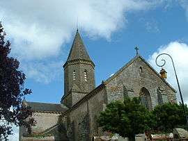
The church in Châteauponsac | ||
| ||
 Châteauponsac | ||
|
Location within Nouvelle-Aquitaine region  Châteauponsac | ||
| Coordinates: 46°08′05″N 1°16′37″E / 46.1347°N 1.2769°ECoordinates: 46°08′05″N 1°16′37″E / 46.1347°N 1.2769°E | ||
| Country | France | |
| Region | Nouvelle-Aquitaine | |
| Department | Haute-Vienne | |
| Arrondissement | Bellac | |
| Canton | Châteauponsac | |
| Intercommunality | Gartempe – Saint Pardoux | |
| Government | ||
| • Mayor (2008–2014) | Gérard Rumeau | |
| Area1 | 68.79 km2 (26.56 sq mi) | |
| Population (2006)2 | 2,250 | |
| • Density | 33/km2 (85/sq mi) | |
| Time zone | CET (UTC+1) | |
| • Summer (DST) | CEST (UTC+2) | |
| INSEE/Postal code | 87041 / 87290 | |
| Elevation |
196–471 m (643–1,545 ft) (avg. 299 m or 981 ft) | |
|
1 French Land Register data, which excludes lakes, ponds, glaciers > 1 km² (0.386 sq mi or 247 acres) and river estuaries. 2 Population without double counting: residents of multiple communes (e.g., students and military personnel) only counted once. | ||

Châteauponsac (Occitan: Chastel Ponçac), also known locally as Château Lorraine, is a commune in the Haute-Vienne department in the Nouvelle-Aquitaine region in western France.
Geography
The river Semme flows westward to the north of the commune, then forms part of the commune's northern border And the river Gartempe flows to the south through an impressive ravine below the 12th century church heading toward Poitiers and joining with the river Vienne
Inhabitants are known as Châtelots.
Sights
Its twelfth-century church is dedicated to Saint Thyrsus.
Births
- Jean Baubérot (born on 26 July 1941), French historian and sociologist
See also
References
External links
- Châteauponsac at Art Roman (French)
| Wikimedia Commons has media related to Châteauponsac. |
This article is issued from Wikipedia - version of the 11/11/2016. The text is available under the Creative Commons Attribution/Share Alike but additional terms may apply for the media files.