Cần Thơ Bridge
| Cần Thơ Bridge Cầu Cần Thơ | |
|---|---|
 | |
| Coordinates | 10°1′53.95″N 105°48′31.1″E / 10.0316528°N 105.808639°E |
| Crosses | Sông Hậu Giang (Bassac River) |
| Locale | Cần Thơ, Vietnam |
| Characteristics | |
| Design | Cable-stayed bridge |
| Total length | 2,750 metres (9,022 ft), 15,850 metres (52,001 ft) include approach ramps |
| Width | 23.1 metres (76 ft) |
| Height | 175.3 metres (575 ft) |
| Longest span | 550 metres (1,804 ft) |
| Clearance above | 39 metres (128 ft) |
| History | |
| Construction begin | September 25, 2004 |
| Opened | April 24, 2010 |
Cần Thơ Bridge (Vietnamese: Cầu Cần Thơ), is a cable-stayed bridge over the Hậu (Bassac) River, the largest distributary of the Mekong River, in the city of Cần Thơ in southern Vietnam. The bridge is 2.75 kilometres long (1.68 miles). It has a 6-lane carriageway measuring 23 metres (76 feet) in width, with 4 lanes for traffic and two lanes for bicycles and motorbikes. It has a clearance of 39 metres (128 feet), which allows large ships to pass underneath it.[1] The bridge was inaugurated on April 24, 2010.[2]
Construction
Prime Minister Phan Văn Khải launched construction of the bridge on September 25, 2004, which was scheduled to be completed in late 2008. The collapse of the partially built bridge in 2007 delayed its opening. The bridge is one of seventeen bridges planned to integrate the Mekong Delta into the road network of Vietnam by 2020. The bridge replaced the network of ferries on the National Route 1A linking Vĩnh Long Province on the east shore with Cần Thơ city on the westbank.[1]
The construction of the bridge was supervised by the consultant group Nippon Koei-Chodai and contracted to several Japanese contractors: Taisei Corporation, Kajima Construction and Nippon Steel. Capital for the project was funded by the Japan International Cooperation Agency with official development assistance loan from the Japan Bank of International Cooperation and the Vietnamese government.[1] Cần Thơ Bridge is insured by the Petrolimex Joint Stock Insurance Company and PetroVietnam Insurance Company for 3.2 trillion Vietnamese đồng (200 million U.S. dollars).[3]
The construction of the Cần Thơ Bridge was subdivided into three contracts, with one contractor handling the first approach bridge, the second building the main bridge, and the third constructing the southern approach road into Cần Thơ.[4]
Collapse
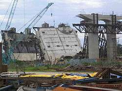
A 90-meter approach ramp of the Cần Thơ Bridge collapsed during construction, on the morning of September 26, 2007, falling from 30 meters in the air.[5] The collapsed section was above a small island located on the Vĩnh Long side of the bridge.[6] There were 250 engineers and workers working on and under the span at the time;[7] the official death toll is 54, with 80 severe injuries.[8] According to Dr. Trần Chủng, head of the national construction QA/QC authority under the Ministry of Construction, this is the most catastrophic disaster in the history of Vietnam's construction industry.[9]
Rescue efforts
Immediately following the accident, many workers at the site joined the rescue forces to take the injured out of the debris,[10] and Chợ Rẫy Hospital in Hồ Chí Minh City sent two professional rescue teams to the site.[11] Local people, students, and cadres joined the rescue teams. International agencies contributed rescue personnel and funding.[12] Rescue efforts were carried out with cranes rather than by direct rescue personnel because of the risk of collapse of the remaining part of the bridge.[13]
Aftermath
An inquiry into the cause of the collapse spent 8 months investigating. Initially, it was discovered that the temporary scaffolding that had given out had been under-specified, using narrower margins to save costs. Ultimately, the proximate cause was determined to be building the scaffolding partially on soft sand, which settled unevenly and caused the scaffolding to tilt.[8] In 2009, the Vietnamese government banned the Taisei and Kajima Construction companies from operating in Vietnam for one year, blaming the two Japanese companies for failing to secure the bridge support.[14]
Opening
The largest bridge in the region, was completed on April 12 and opened for traffic on April 24, 2010.
References
- 1 2 3 "SE Asia's longest cable-stayed bridge underway in Can Tho". September 28, 2004. Archived from the original on September 1, 2007. Retrieved September 28, 2007.
- ↑ "Inauguration of Can Tho Bridge, linking a range of transport". April 26, 2010. Archived from the original on March 7, 2012. Retrieved June 2, 2010.
- ↑ "Bridge collapse kills at least 52". 2007-09-28. Retrieved September 29, 2007.
- ↑ "World price hike hits Mekong projects". 2005-03-10. Archived from the original on March 16, 2008. Retrieved September 29, 2007.
- ↑ "Can Tho bridge collapses, dozens of people die". Vietnam Net. 2007-09-27. Archived from the original on 2007-10-23. Retrieved 2007-09-26.
- ↑ "Vietnam bridge collapse kills 43". AP. Taipai Times. 2007-09-28. Retrieved 2007-09-30.
- ↑ "Fatalities In Vietnam's Can Tho Bridge Collapse Surge To 59". au.news.yahoo.com. Archived from the original on 2007-10-13. Retrieved 2007-09-27.
- 1 2 High, Richard (2008-07-07). "Inquiry reports on Vietnam's Can Tho Bridge collapse". International Construction. KHL Group. Retrieved 2016-09-16.
- ↑ "Collapse of Can Tho Bridge, the most serious disaster in the history of Vietnam's construction". Liberated Saigon News (in Vietnamese). 2007-09-29. Archived from the original on 2007-10-30. Retrieved 2007-09-29.
- ↑ MINH GIẢNG - QUANG VINH - PHƯƠNG NGUYÊN (27 September 2007). "10 giây kinh hoàng". Tuoi Tre (in Vietnamese). Retrieved 2007-09-27.
- ↑ "'Còn nhiều người chờ chúng tôi đến cứu'". VnExpress (in Vietnamese). 27 September 2007. Archived from the original on 2007-10-25. Retrieved 2007-09-27.
- ↑ "International SOS Assists Victims of Can Tho Bridge Collapse". AmCham Vietnam. 2007-09-27. Retrieved 2016-09-20.
- ↑ "Sập cầu Cần Thơ, hàng chục người thiệt mạng" [Collapse of Can Tho Bridge, dozens killed] (in Vietnamese). Archived from the original on 2007-10-26.
- ↑ Nguyen Dieu Tu Uyen (July 21, 2009). "Vietnam Bans Japan's Taisei, Kajima From Projects (Update1)". Bloomberg L.P. Retrieved August 8, 2012.
External links
| Cambodia | 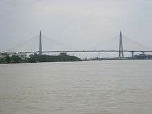 | |
|---|---|---|
| Indonesia | ||
| Malaysia | ||
| Philippines | ||
| Thailand | ||
| Vietnam | ||
Cable-stayed bridges by country | ||
Coordinates: 10°1′53.95″N 105°48′31.1″E / 10.0316528°N 105.808639°E