Calder Highway
| Calder Highway New South Wales–Victoria | |
|---|---|
 | |
| General information | |
| Type | Highway |
| Length | 448 km (278 mi) |
| Route number(s) |
|
| Former route number | |
| Major junctions | |
| NW end |
|
|
for full list see major intersections | |
| SE end |
|
| Location(s) | |
| Major settlements | Mildura, Ouyen, Charlton, Bendigo |
| Highway system | |
|
Highways in Australia National Highway • Freeways in Australia Highways in New South Wales Highways in Victoria | |
| |
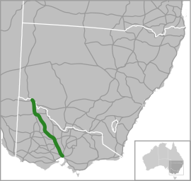
Calder Highway[1] is a highway in Australia, linking Ravenswood South in Victoria, to Mildura. North of the Victoria/New South Wales border, the highway continues north to Broken Hill, Tibooburra and the New South Wales/Queensland border as the Silver City Highway, as route B79 as far as Broken Hill.[2]
History
The Calder Highway was named after William Calder, who was chairman of the Country Roads Board from 1913 to 1928. The CRB was renamed Victorian Road Construction Authority and is today known as VicRoads.
The highway was originally allocated a National Route 79 shield. With Victoria's conversion to the newer alphanumeric system in the late 1990s this was altered to an A79 designation for the majority highway portion, with the New South Wales section allocated B79 in 2013.
Route
South of the Victoria/New South Wales border the highway is a two-lane, single carriageway in each direction, continuing through northwest Victoria from the Abbotsford Bridge, through Merbein to the major regional town of Mildura in the state's north-west. Here also it crosses the Sturt Highway (A20) leading to capital cities Adelaide heading west and Sydney heading east. Further south, it crosses the Mallee Highway (B12) at Ouyen and runs south-east eventually to Bendigo. Between Wycheproof and Red Cliffs the highway has a speed limit of 110 km/h.
The Calder Alternate Highway (A790) leaves the A79 just north of Ravenswood and bypasses the Bendigo suburban area, rejoining the A79 at Marong, west of Bendigo.
For most of its length from Bendigo to its end at its junction with the Tullamarine Freeway in Melbourne, the Calder Highway is a four lane dual carriageway, upgraded to freeway standard as the Calder Freeway. The Old Calder Highway has been designated C794 from where it leaves the new Calder Freeway at Ravenswood South.
Gallery of notable sights
-
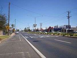
The Calder Highway, passing through Irymple.
-
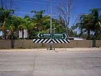
The end of the Calder Highway at the intersection of the Silver City Highway, near Curlwaa, New South Wales.
-
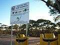
Fruit disposal bins and warning signs along the Calder Highway, approaching the Fruit Fly Exclusion Zone near Mildura.
Major Intersections and Towns
| State | LGA | Location | km | mi | Destinations | Notes |
|---|---|---|---|---|---|---|
| New South Wales | Wentworth | Curlwaa | 565 | 351 | ||
| Murray River | 564.5 | 350.8 | Abbotsford Bridge | |||
| State border | New South Wales – Victoria state border | |||||
| Victoria | Mildura | Merbein | 553.5 | 343.9 | ||
| Mildura | 544 | 338 | ||||
| 541 | 336 | |||||
| 539 | 335 | |||||
| Irymple | 537 | 334 | ||||
| Red Cliffs | 528 | 328 | ||||
| 526 | 327 | |||||
| 525 | 326 | Kulkyne Way – Colignan | ||||
| Hattah | 476 | 296 | ||||
| Ouyen | 440.8 | 273.9 | ||||
| 440.7 | 273.8 | |||||
| 430 | 270 | |||||
| Mittyack | 404 | 251 | ||||
| Buloke | Bimbourie | 371 | 231 | |||
| Sea Lake | 356 | 221 | ||||
| 352 | 219 | concurrent with C246 through Sea Lake | ||||
| 351.5 | 218.4 | |||||
| Dumosa | 291 | 181 | ||||
| Wycheproof | 276 | 171 | ||||
| 275 | 171 | |||||
| Wycheproof South | 269 | 167 | ||||
| Charlton | 246 | 153 | ||||
| 245 | 152 | |||||
| 244 | 152 | |||||
| Loddon | Wedderburn | 213.7 | 132.8 | concurrent with C273 past Wedderburn oval | ||
| 213.5 | 132.7 | |||||
| Inglewood | 185 | 115 | ||||
| Bridgewater | 178 | 111 | ||||
| 177 | 110 | |||||
| Greater Bendigo | Marong | 155 | 96 | |||
| Golden Square | 155 | 96 | ||||
| Ironbark | 153 | 95 | ||||
| 152.4 | 94.7 | |||||
| Bendigo | 150 | 93 |
| concurrent with A300 | ||
| Golden Square | 147.4 | 91.6 | ||||
| Kangaroo Flat | 145 | 90 | ||||
| Ravenswood | 135 | 84 | ||||
| Harcourt North | 126 | 78 | Continues as Calder Freeway | |||
1.000 mi = 1.609 km; 1.000 km = 0.621 mi
| ||||||
References
- ↑ Calder Freeway & Calder Highway (M/A79), Expressway - Paul Rands. Retrieved on 11 September 2013.
- ↑ Silver City Highway, Tibooburra, 2007-12-25