Pinnaroo, South Australia
| Pinnaroo South Australia | |||||||||||||
|---|---|---|---|---|---|---|---|---|---|---|---|---|---|
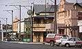 Pinnaroo main street, looking east | |||||||||||||
 Pinnaroo | |||||||||||||
| Coordinates | 35°15′0″S 140°54′0″E / 35.25000°S 140.90000°ECoordinates: 35°15′0″S 140°54′0″E / 35.25000°S 140.90000°E | ||||||||||||
| Population | 558 (2011 census)[1] | ||||||||||||
| Established | 1904[2] | ||||||||||||
| Postcode(s) | 5304 | ||||||||||||
| Location | 243 km (151 mi) east of Adelaide | ||||||||||||
| LGA(s) | Southern Mallee District Council | ||||||||||||
| State electorate(s) | Electoral district of Chaffey | ||||||||||||
| Federal Division(s) | Division of Barker | ||||||||||||
| |||||||||||||
Pinnaroo is a town in the Murray Mallee region of South Australia, near the border with Victoria 243 km east of Adelaide. Pinnaroo is on the Mallee Highway, and the railway line between Tailem Bend and Ouyen. The roadhouses on the highway are the first food and leg-stretch stop on the bus route from Adelaide to Sydney. At the 2006 census, Pinnaroo had a population of 558.[1]
The town's name is derived from "big man" in a local Aboriginal language.[3]
The railway arrived in the area in 1906.[4] There had not been any significant development in the area before that, as the remoteness and difficulty of getting supplies in and produce out had made it uneconomic to farm before that.
The Border Times is a weekly newspaper published in the town.
The Town has a large variety of sports for a town of 900, such as Australian Rules Football, Netball, Cricket, Tennis, Basketball, Volleyball, Lawnbowls, Badminton, Golf and darts. The towns local football team, the Pinnaroo Supa Roos play in the Mallee Football League.
Pinnaroo also has a show and field days every year at the start of October. The Pinnaroo Show features dog trials, agricultural tents, competitions, horse events, keg tosses, animal judging and fireworks. The show attracts over 10,000 people every year. Another event Pinnaroo hosts is the Pinnaroo SpudFest. The SpudFest features a black tie dinner, stalls and games, entertainment, and Spud Wrestling.[5]
The railway is not currently available for transport between the states, as the line from Tailem Bend was converted to standard gauge soon after the main Adelaide–Melbourne line was converted, but the line to Ouyen remains as broad gauge. Both sides are used to transport grain from silos along the railway line towards the ports in each state.
The town has also become a major centre for growing potatoes since around 1990.[6]
The Peebinga Conservation Park is 42 km north of Pinnaroo, Karte Conservation Park 30 km north-west and the much larger Ngarkat Conservation Park is 28 km south of the town.[4]
The postcode for Pinnaroo is 5304. Pinnaroo is the seat of the Southern Mallee District Council, and is in the South Australian House of Assembly Electoral district of Chaffey and the Australian House of Representatives Division of Barker.
Pinnaroo Primary School
Pinnaroo Primary School is a public primary school for students in Reception to Year 7, and has approximately 70 students. The school has four composite classes - Reception, Years 1 and 2, Years 3 and 4, and Years 5,6 and 7. It is the only school within 30 km of the town. As of 2013, the school's principal is Sunyl Vogt and the school slogan is Aim High. The school regularly takes part in interschool sports with neighbouring schools, Lameroo and Geranium, in swimming and athletics. The school also takes part in SAPSASA with the Murray Mallee team in sports such as Australian Rules Football, Cricket, Athletics, Swimming, Golf, Softball, Tennis, Netball and Basketball. The school has four classrooms, a GP room, an art and technical centre, a home economics centre, an FM radio station, a swimming pool, two ovals, outdoor tennis, netball and basketball courts, and a full size gymnasium.
Pinnaroo Primary School is the home of South Australia's first Community Library which opened in 1977.[7]
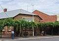
Gallery
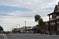 Main Street
 Main Street
- Main Street
 Post Office
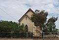
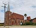 Lutheran Church
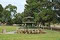 Fountain
 Golden Grain Hotel
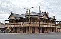 Hotel
Hotel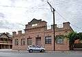 Pinnaroo Institute
 Memorial Clock
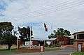 Memorial Hospital
 War Memorial
References
| Wikimedia Commons has media related to Pinnaroo, South Australia. |
- 1 2 Australian Bureau of Statistics (31 October 2012). "Pinnaroo (L) (Urban Centre/Locality)". 2011 Census QuickStats. Retrieved 28 March 2013.
- ↑ "Pinnaroo". PlaceNames Online. Land Services SA. 2003-06-16. Retrieved 2007-07-07.
- ↑ "Hundred of Pinnaroo". PlaceNames Online. Land Services SA. 2003-06-16. Archived from the original on 2007-09-30. Retrieved 2007-07-07.
- 1 2 "Pinnaroo". Walkabout. Fairfax Media. Retrieved 2007-07-07.
- ↑ "Pinnaroo Spudfest 2008". South Australia Central. South Australian Tourism Commission, Government of South Australia. Retrieved 2008-03-25.
- ↑ Graham Badger; Ian Henschke (2004-04-02). "The Humble Potato is Saving One of South Australia's Country Towns". Stateline (South Australian edition). Australian Broadcasting Company. Retrieved 2007-07-07.
- ↑ "Pinnaroo Community Library". Southern Mallee District Council. Retrieved 2008-01-20.