Campo Indian Reservation
|
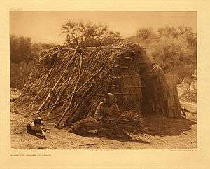
Kumeyaay woman in front of her traditional house at Campo, photo by Edward Curtis | |
| Total population | |
|---|---|
| 351 reservation residents[1] | |
| Regions with significant populations | |
|
| |
| Languages | |
| Kumeyaay,[2] Tipai[3] English | |
| Religion | |
|
Traditional tribal religion, Christianity (Roman Catholicism)[4] | |
| Related ethnic groups | |
|
other Kumeyaay people,[1][5] Cocopa, Quechan, Paipai, and Kiliwa |
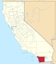
The Campo Indian Reservation is home to the Campo Band of Diegueno Mission Indians, also known as the Campo Kumeyaay Nation, a federally recognized tribe of Kumeyaay people in the southern Laguna Mountains, in eastern San Diego County, California.[3] The reservation was founded in 1893 and is 16,512 acres (66.82 km2) large.[1][2]
Government
The Campo Band is headquartered in Campo, California. They ratified their tribal constitution on July 13, 1975, which established a governing council consisting of all band members aged 18 or over. The democratically elected Executive Committee currently includes:
- Chairperson: Ralph Goff
- Vice Chairperson: Harry Paul Cuero Jr.
- Treasurer: Marcus Cuero
- Secretary: Annah Ceballos
- Committee Member: Steven M. Cuero
- Committee Member: Vanessa Parkhurst
- Committee Member: Brian Connolly [6]
Services
In 1990, the Campo Band created the Campo Environmental Protection Agency (CEPA), which protects the environment and public health in the face of commercial development.[7] The tribe also has the Campo Indian Education Center and Campo Tribal Tribal Training Program.[5]
Topography

There are two areas included in the reservation, found on US Geological Survey feature ID 270242. The address for the tribal government is in the portion of the reservation north of Campo and Cameron Corners. This area is shown on the US Geological Survey Campo and Cameron Corners, California 7.5-minute quadrangles. While not a true square, this part of the reservation is roughly one mile across on each side. A point suitable for finding the reservation on a map is latitude/longitude.[8]
A second, larger area of the Campo Indian Reservation is located to the east in the area around the community of Live Oak Springs. This area is shown on the US Geological Survey Live Oak Springs and Tierra del Sol, California 7.5-minute quadrangles. This portion is rectangular: about six miles (10 km) in the north-south dimension and about 3.2 miles (5.1 km) in the east-west dimension.[9] Live Oak Springs is located at latitude/longitude 32°41′26″N 116°20′01″W / 32.69056°N 116.33361°W. The south extent of the area is about 0.4 miles (0.64 km) north of the Mexican border.[10]
Economic development
Muht Hei, Inc. is the tribe's corporation, which oversees Golden Acorn Casino, Campo Materials, and Kumeyaay Wind, a wind farm with 25 turbines.[11] The tribe owns and operates the Golden Acorn Casino, the Golden Grill Restaurant, the Del Oro Deli, and a travel center, all located in Campo.[12]
Internet
Portions of this remote area have wireless Ethernet Internet capability for tribe members. The service is provided through the Tribal Digital Village based on the Pala Indian Reservation, about 80 miles (130 km) north. This was reported in the San Diego Union Tribune, New York Times, and on the Community Television of Southern California program, California Connected.[13]
See also
Notes
- 1 2 3 "California Indians and Their Reservations: C." SDSU Library and Information Access. Retrieved 12 Aug 2013.
- 1 2 Shipek, 612
- 1 2 Eargle, 205
- ↑ Pritzker, 147
- 1 2 "Campo Band of Kumeyaay Indians." Southern California Tribal Chairmen's Association. Retrieved 12 Aug 2013.
- ↑ "Leadership." Campo Kumeyaay Nation. 2013. Retrieved 12 Aug 2013.
- ↑ "Campo Kumeyaay Nation." The Climate Registry. Retrieved 12 Aug 2013.
- ↑ Cameron Corners, California, 7.5-minute quadrangle, US Geological Survey, 1988. Campo, California, 7.5-minute quadrangle, US Geological Survey, 1997.
- ↑ Tierra del Sol, California, 7.5-minute quadrangle, US Geological Survey, 1997.
- ↑ Live Oak Springs, California, 7.5-minute quadrangle, US Geological Survey, 1997.
- ↑ "Muht Hei, Inc." Campo Kumeyaay Nation. Retrieved 12 Aug 2013.
- ↑ "Dining." Golden Acorn Casino. 2009 (retrieved 3 June 2010)
- ↑ "Campo Band of Kumeyaay Indians." Southern California Tribal Chairmen's Association. Retrieved 3 June 2010.
References
- Eargle, Jr., Dolan H. California Indian Country: The Land and the People. San Francisco: Tree Company Press, 1992. ISBN 0-937401-20-X.
- Pritzker, Barry M. A Native American Encyclopedia: History, Culture, and Peoples. Oxford: Oxford University Press, 2000. ISBN 978-0-19-513877-1.
- Shipek, Florence C. "History of Southern California Mission Indians." Handbook of North American Indians. Volume ed. Heizer, Robert F. Washington, DC: Smithsonian Institution, 1978. 610-618. ISBN 0-87474-187-4.
External links
- Official Campo Kumeyaay Nation website
- Golden Acorn Casino.com: Campo Tribal History
- Kumeyaay.info: The Kumeyaay Tribes Guide — Tribal Bands of the Kumeyaay Nation (Diegueño) — in San Diego County, California + Baja California state, México.
Coordinates: 32°38′29″N 116°28′17″W / 32.64139°N 116.47139°W

