Tecate, California
| Tecate | |
|---|---|
| Unincorporated community | |
|
Mexico-United States border crossing from Tecate, California | |
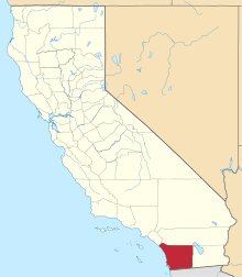
 Tecate Location within the state of California | |
| Coordinates: 32°34′38″N 116°37′36″W / 32.57722°N 116.62667°WCoordinates: 32°34′38″N 116°37′36″W / 32.57722°N 116.62667°W | |
| Country | United States |
| State | California |
| County | San Diego |
| Population (2000) | |
| • Total |
207[1] (71.01% of the population is Hispanic or Latino of any race)[2] |
| Time zone | Pacific (PST) (UTC-8) |
| • Summer (DST) | PDT (UTC-7) |
| ZIP codes | 91980 |
| Area code(s) | 619 |
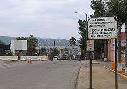
Tecate is an unincorporated community in the Mountain Empire area of southeastern San Diego County, California, directly adjacent to the Mexican city of Tecate, Baja California. The area is best known for its border crossing between the United States and Mexico, and nearby Tecate Peak.
Even though San Diego has communities more southern than Tecate, the city proper is located at a more northern latitude, making Tecate the southernmost settlement in the state of California.
References
This article is issued from Wikipedia - version of the 4/20/2016. The text is available under the Creative Commons Attribution/Share Alike but additional terms may apply for the media files.