Cape Cod Airfield
| Cape Cod Airfield | |||||||||||||||||||
|---|---|---|---|---|---|---|---|---|---|---|---|---|---|---|---|---|---|---|---|
 | |||||||||||||||||||
| IATA: none – ICAO: K2B1 – FAA LID: 2B1 | |||||||||||||||||||
| Summary | |||||||||||||||||||
| Airport type | Public | ||||||||||||||||||
| Operator | Town of Barnstable | ||||||||||||||||||
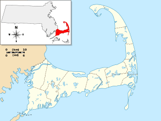
| Location | Marstons Mills, Massachusetts | ||||||||||||||||||
| Elevation AMSL | 103 ft / 31 m | ||||||||||||||||||
| Coordinates | 41°41′07.0″N 70°24′08.1″W / 41.685278°N 70.402250°WCoordinates: 41°41′07.0″N 70°24′08.1″W / 41.685278°N 70.402250°W | ||||||||||||||||||
| Website | Official website | ||||||||||||||||||
| Map | |||||||||||||||||||
 2B1 | |||||||||||||||||||
| Runways | |||||||||||||||||||
| |||||||||||||||||||
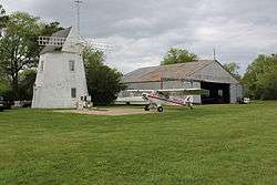
Cape Cod Airfield, (ICAO: K2B1, FAA LID: 2B1) in Marstons Mills, Massachusetts is a public airport owned by the Town of Barnstable. It has three runways, averages 75 flights per week, and has approximately 20 aircraft based on its field.[1] Biplane Rides, flight school, and skydive operations on the field. In the 1930s, the Massachusetts National Guard attended summer training at Camp Perkins, a national guard camp which was active on the site during the early 1920s and possibly longer.[2]
References
- ↑ "Danforth property waits its turn". The Barnstable Patriot. 10 February 2012. Retrieved 2014-02-22.
External links
| Wikimedia Commons has media related to Cape Cod Airport. |
- Resources for this airport:
- FAA airport information for 2B1
- AirNav airport information for 2B1
- FlightAware airport information and live flight tracker
- SkyVector aeronautical chart for 2B1
This article is issued from Wikipedia - version of the 9/20/2016. The text is available under the Creative Commons Attribution/Share Alike but additional terms may apply for the media files.