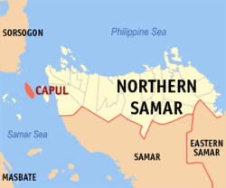
Capul
| Capul Abak | |
|---|---|
| Municipality | |
|
USS Essex passes Capul Island while passing through the San Bernardino Strait | |
 Map of Northern Samar with Capul highlighted | |
.svg.png) Capul Location within the Philippines | |
| Coordinates: 12°25′N 124°11′E / 12.417°N 124.183°ECoordinates: 12°25′N 124°11′E / 12.417°N 124.183°E | |
| Country | Philippines |
| Region | Eastern Visayas (Region VIII) |
| Province | Northern Samar |
| Barangays | 12 |
| Government[1] | |
| • Mayor | Isidro S. Bandal |
| • Vice-Mayor | Joselito Catucod |
| Area[2] | |
| • Total | 35.56 km2 (13.73 sq mi) |
| Population (2010)[3] | |
| • Total | 12,659 |
| • Density | 360/km2 (920/sq mi) |
| Time zone | PST (UTC+8) |
| ZIP code | 6408 |
| Dialing code | 55 |
Capul is a fifth class island municipality in the province of Northern Samar, Philippines. According to the 2010 census, it has a population of 12,659 people.[3] Prior to its founding as a town, Capul Island itself with its lighthouse built on the island, served as a guidepost for the Acapulco-Manila galleon trade vessels passing through the treacherous waters of San Bernardino Strait. It also served as the capital of Samar from 1848 to 1852. The name Capul came from the word Acapulco, an old trading post in Mexico.[4]
Capul is the only town in the province of Northern Samar with a distinct language, Inabaknon, instead of Waray-Waray, the native language spoken by the locals of Samar island.
Barangays
Capul is politically subdivided into 12 barangays.[2]
- Aguin
- Jubang
- Landusan
- Oson
- Poblacion Barangay 1
- Poblacion Barangay 2
- Poblacion Barangay 3
- Poblacion Barangay 4
- Poblacion Barangay 5
- Sagaosawan
- San Luis
- Sawang
Demographics
| Population census of Capul | ||
|---|---|---|
| Year | Pop. | ±% p.a. |
| 1990 | 9,510 | — |
| 1995 | 9,964 | +0.88% |
| 2000 | 10,619 | +1.37% |
| 2007 | 11,289 | +0.85% |
| 2010 | 12,659 | +4.26% |
| Source: National Statistics Office[3][5] | ||
Language
Capul has a different language from the rest of Northern Samar and the rest of Eastern Visayas. The native language in the island-municipality is Inabaknon. Inabaknon has been classified by linguists as a Sama language related to the Sama languages of Mindanao, rather than a Visayan language. Nonetheless the Capul people understand the Waray language, as spoken by the majority of the people in Northern Samar.
Tourism
Capul Church and Fortress
- The Capul Church, built during the Spanish Colonial Period, is dedicated to St. Ignatius of Loyola and is surrounded by a square fort with bulwarks of dissimilar designs.[6] The church structure was actually the third that was built on the site. The first two structures, made of hard wood and nipa roofs, were razed when Moro pirates plundered the island in 1615 and 1768. In 1781, Fr. Mariano Valero, a Spanish architect-priest led the restoration of the church and built the stonewall fortress similar to that in Intramuros, Manila that would fortify it against Moro attacks.[7]
Capul Watchtower
- Located on a hill near the Capul fort overlooking the town harbor, a stone watchtower was erected to serve as a sentry or warning system and a refuge for indigents during Moro raids.
Bitō Cave
- Bitō Cave, also known as Beto Cave, is a popular natural attraction located in Sawang.
Timon-timon Rock
- Timon-timon is a rudder-shaped rock formation located near the southern point of the island.
References
- ↑ "Municipalities". Quezon City, Philippines: Department of the Interior and Local Government. Archived from the original on 25 January 2013. Retrieved 15 April 2013.
- 1 2 "Province: Northern Samar". PSGC Interactive. Makati City, Philippines: National Statistical Coordination Board. Archived from the original on 1 January 1970. Retrieved 15 April 2013.
- 1 2 3 "Total Population by Province, City, Municipality and Barangay: as of May 1, 2010" (PDF). 2010 Census of Population and Housing. National Statistics Office. Archived from the original (PDF) on 20 March 2013. Retrieved 15 April 2013.
- ↑ http://newsinfo.inquirer.net/44465/ancient-fortress-church-of-capul-northern-samar
- ↑ "Province of Northern Samar". Municipality Population Data. LWUA Research Division. Retrieved 20 August 2013.
- ↑ Explore Capul Island Archived June 6, 2010, at the Wayback Machine.
- ↑ Philippines & Cebu Real Estate
External links
| Wikivoyage has a travel guide for Capul, Northern Samar. |
- Philippine Standard Geographic Code
- Philippine Census Information
- Capul Island Travel Guide
- Local Governance Performance Management System
- Explore Capul Island
- Capul on Biyahero, Philippine Travel Portal
 |
Matnog, Sorsogon / San Bernardino Strait | San Bernardino Strait |  | |
| |
Capul Pass / San Antonio | |||
| ||||
| | ||||
| San Vicente / Samar Sea | Samar Sea |
_passes_the_Capul_Island_Lighthouse_as_it_transits_through_the_San_Bernardino_Straits.jpg)