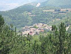
Carapelle Calvisio
| Carapelle Calvisio | ||
|---|---|---|
| Comune | ||
| Comune di Carapelle Calvisio | ||
 | ||
| ||
 Carapelle Calvisio Location of Carapelle Calvisio in Italy | ||
| Coordinates: 42°18′1″N 13°41′8″E / 42.30028°N 13.68556°ECoordinates: 42°18′1″N 13°41′8″E / 42.30028°N 13.68556°E | ||
| Country | Italy | |
| Region | Abruzzo | |
| Province / Metropolitan city | L'Aquila (AQ) | |
| Government | ||
| • Mayor | Domenico Di Cesare | |
| Area | ||
| • Total | 14.39 km2 (5.56 sq mi) | |
| Elevation | 910 m (2,990 ft) | |
| Population (31 December 2013)[1] | ||
| • Total | 85 | |
| • Density | 5.9/km2 (15/sq mi) | |
| Demonym(s) | Carapellesi | |
| Time zone | CET (UTC+1) | |
| • Summer (DST) | CEST (UTC+2) | |
| Postal code | 67020 | |
| Dialing code | 0862 | |
| Patron saint | San Pancrazio martire | |
| Saint day | 12 May | |
Carapelle Calvisio is a comune and town in the province of L'Aquila in the Abruzzo region of central Italy. It is located in the natural park known as the Gran Sasso e Monti della Laga National Park at 900 metres (3,000 ft) above sea level. It is mostly known as being one of the smallest non-alpine comunes in Italy, with 85 inhabitants as of 31 December 2013. It is located directly some kilometers from the historical castle Rocca Calascio.
Carapelle Calvisio's location (separated by a mountain from L'Aquila area) preserved it from serious damage in the earthquake of L'Aquila on 6 April 2009.
References
External links
This article is issued from Wikipedia - version of the 11/14/2016. The text is available under the Creative Commons Attribution/Share Alike but additional terms may apply for the media files.
