Carbis
"Woon" redirects here. For individuals with the surname Woon, see Woon (surname).

Coordinates: 50°24′04″N 4°49′01″W / 50.401°N 4.817°W
Carbis is a hamlet 0.9 miles (1.4 km) east of Roche in Cornwall, England.[1] Carbis lies at about 495 feet (151 m) above sea level.[1]
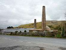
Old china clay works at Carbis
Rosemellyn China Clay works lies 0.4 miles (0.64 km) north-east of Carbis. In the 19th century the mining of china clay was an important industry around St Austell indeed the area has the nick-name of the "china clay country". The Rosemellyn China Clay company went into liquidation in 1918. A short railway branch line (now dismantled) ran from Carbis Wharf to the sidings at nearby Bugle as part of the Cornwall Minerals Railway.[1]
References
- 1 2 3 "DEFRA Magic Map Application". DEFRA. Retrieved 10 January 2016.
Cornwall Portal | |
| Unitary authorities | |
| Major settlements |
|
| Rivers | |
| Topics | |
This article is issued from Wikipedia - version of the 5/4/2016. The text is available under the Creative Commons Attribution/Share Alike but additional terms may apply for the media files.