River Camel
| River Camel (Dowr Kammel) | |
| River | |
 The Camel valley in winter. Taken from between Pendavey bridge and Polbrock looking upstream. | |
| Country | United Kingdom |
|---|---|
| Region | Cornwall |
| Tributaries | |
| - left | River Ruthern |
| - right | De Lank River, River Allen |
| Source | Hendraburnick Down |
| - location | Bodmin Moor |
| - coordinates | 50°39′33″N 4°38′29″W / 50.65917°N 4.64139°W |
| Mouth | Padstow Bay |
| - location | Padstow, North Cornwall coast |
| - coordinates | 50°33′02″N 4°53′37″W / 50.55056°N 4.89361°WCoordinates: 50°33′02″N 4°53′37″W / 50.55056°N 4.89361°W |
| Length | 48 km (30 mi) |
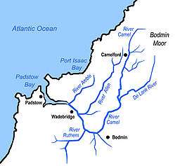 Sketch map of the River Camel and its tributaries | |
The River Camel (Cornish: Dowr Kammel, meaning crooked river) is a river in Cornwall, England, UK. It rises on the edge of Bodmin Moor and with its tributaries drains much of North Cornwall. The river flows into the eastern Celtic Sea between Stepper Point and Pentire Point having covered about 30 miles. The river is tidal upstream to Egloshayle and is popular for sailing, birdwatching and fishing. The name Camel comes from the Cornish language for 'the crooked one', a reference to its winding course. Historically the river was divided into three named stretches. Heyl (Cornish: Heyl, meaning estuary) was the name for the estuary up to Egloshayle, the River Allen (Cornish: Dowr Alen, meaning shining river) was the stretch between Egloshayle and Trecarne, whilst the Camel was reserved for the stretch of river between its source and Trecarne.[1]
Geology and hydrology
The River Camel rises on Hendraburnick Down (UK Grid Reference SX135875) on the edge of Bodmin Moor, an area which forms part of the granite spine of Cornwall. The river's course is through upper and middle Devonian rocks,[2] predominantly the Upper Delabole Slates, Trevose Slates and Polzeath Slates that stretch to the coast, although Pentire Head is composed mainly of pillow lavas.[3] The only active quarry in the River Camel catchment area is at Delabole[4] and there has been mining for lead and silver on Pentire Head,[5] and building stone at various locations. Further inland mines surrounding the Camel and its tributaries produced tin,[6][7] lead, copper[8] and iron; Mulberry Mine near Ruthernbridge produced 1300 tons of tin between 1859 and 1916.[9] Several small China Clay pits also operated in the 19th century around Blisland.[10][11][12]

The source of the Camel is at 218 metres (715 ft) above sea level[13] and it has an average incline of 7m/km.[13] The upper reaches of the Camel and its tributaries are mainly moorland giving way to woodland and farmland, predominantly livestock.[13] This means that 64.8% of the catchment is grassland, with a further 14.8% arable land and 12.9% woodland. Of the remaining 7.4%, 4.5% is through urban or built-up areas, 2.7% is mountain, heath and bog and the remainder is inland waters.[14]
The Camel's catchment area covers 413 km2[13] on the western side of Bodmin Moor, and is mainly Devonian slates and granite,[15] with some shales and sandstones.[13] Water volumes are affected by the reservoir at Crowdy Marsh, by abstraction of water for public supply, and by effluent from the sewage system around Bodmin. Data collected by the National Water Archive shows that water flow in the River Camel for 2006 was considerably below average. This correlates with reduced rainfall, particularly between the months of June and September. Data from 2013 and 2014 also shows below average annual flow but with points of higher that average flow during Winter.[13]
Estuary

The next five and a half miles beside the broadening Camel to Padstow is the most beautiful train journey I know— John Betjeman, Betjeman's Cornwall[16]
The Camel Estuary (Cornish: Heyl Kammel)[17] stretches from Wadebridge downstream to the open sea at Padstow Bay. The quays at Wadebridge are now developed with apartments and retail space on the west bank. North of the quays, the river passes under a concrete bridge carrying the A39 bypass and past the disused Vitriol Quay. Downstream of Burniere Point the valley widens on the right with acres of salt marsh where the River Amble flows in. Here the Cornwall Birdwatching and Preservation Society has hides on both sides of the river; those on the Camel Trail are open to the public. The main river follows the western side of the valley, while on the eastern side a barrage prevents the rising tide from entering the River Amble.
Downstream from the Amble, an adit can be found on the foreshore below Dinham Hill, only accessible from the foreshore at low tide, the remains of Wheal Sisters copper mine.[8] Cant Cove lies on the east bank below Cant Hill and the rotting ribs of a ship project from the mud. Almost opposite Cant Hill on the west bank is Camel Quarry,[18] the piles of waste rock clearly visible above the river with the remains of a quay visible at low water. From here the mud gives way to sand and Gentle Jane, named after a legendary lady who treated the ills of all comers.[19]
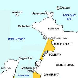
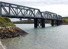
From Porthilly Cove on the east bank, the estuary widens and swings to the north. On the west bank, the Camel Trail crosses the triple-span “Iron Bridge” over Little Petherick Creek then passes below Dennis Hill and its obelisk.
The fishing port of Padstow stands on the west bank from where the Black Tor Ferry (officially owned by the Duchy of Cornwall) carries people across the river to Rock.
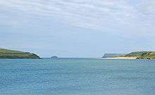
The mouth of the Camel lies between Stepper Point on the west and Pentire Point on the east, and each headland shelters sandy beaches. On the west side of the estuary, Tregirls beach is protected by Stepper Point. At the northern end of Tregirls beach is Harbour Cove and between here and Hawker's Cove evidence has been found of occupation during the Bronze Age, Iron Age and Roman periods, and use of Harbour Cove for trading vessels.[20]
In 1827, Padstow Harbour Association chose Hawker's Cove as the location for the Padstow lifeboat. Operations were taken over by the RNLI in 1856. A new lifeboat station and slipway were built in 1931 and a second lifeboat stationed at Hawker's Cove. The station closed in 1962 because silting rendered the channel too shallow.[21] The building is now converted to residential use.
Beyond Hawkers Cove, the Doom Bar extends across the estuary. The sandbank has been the graveyard of many ships. A legend as to how the Doom Bar came about describes how a local fisherman is reputed to have shot a mermaid with an arrow, with the result that she cursed Padstow by putting the sandbar between the harbour and the sea.[22]
On the east side of the estuary, the village of Rock is centre for sailing, dinghy racing and marine leisure. From Rock, dunes and intertidal sands extend north as far as Brea Hill. Beyond Brea Hill is Daymer Bay with a beach north of which is the settlement of Trebetherick. A stretch of rocky foreshore swings east to the bay and beach at Polzeath, a location for surfing. North of Polzeath, Pentire Point marks the northeast extremity of the estuary.
Recreation
The Camel Estuary has been designated an Area of Outstanding Natural Beauty (AONB), covering the area between Padstow/Rock and Wadebridge.[23] The estuary comprises part of the Cornwall Area of Outstanding Natural Beauty. Almost a third of Cornwall has AONB designation, with the same status and protection as a National Park.
Beaches and bathing
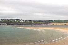
On the western bank Tregirls beach and St Georges Well lie between Stepper Point and Padstow, while on the eastern bank moving upstream from Pentire Point is Polzeath beach, Daymer Bay and Rock. Water quality is monitored at Polzeath and Daymer Bay with water classification for the years 2012 to 2015 for both locations being "Excellent".[24][25] Water quality was previously monitored at Rock, results from 2007 for all three locations on the eastern bank of the river being either "good" or "excellent".[26]
The Camel Trail
The Camel Trail, used by walkers and cyclists, follows the trackbed of the Bodmin and Wadebridge Railway from Wenfordbridge, past the outskirts of Bodmin at Dunmere, and through Wadebridge to Padstow.
Long distance footpaths
The South West Coast Path follows the River Camel from Pentire Point to Rock, and from Padstow to Stepper Point. It crosses the river using the Black Tor Ferry.
The Saints' Way footpath links Padstow with Fowey. It follows first the River Camel, and then Little Petherick Creek from Padstow to Little Petherick, before striking inland and crossing the county to the River Fowey. This route is a very ancient one used by travellers from Ireland and Wales making for Brittany and wishing to avoid the dangerous seas around Lands End.[19]
Water sports
The section of the river between and Tuckingmill Bridge and Penrose Bridge near Blisland is Grade 2 for kayaking but illegal unless you obtain permission from the riparian owners (both banks).[27]
Wildlife and conservation
There are five Sites of Special Scientific Interest (SSSIs) along the length of the Camel. Four small SSSIs at Harbour Cove, Rock Dunes, Trebetherick Point and Pentire Peninsula are on the estuary, while the River Camel Valley and Tributaries SSSI covers much of the Camel Valley between Egloshayle and Blisland, and extends in several further sections of varying size up to its source. This SSSI covers much of the River Allen, a tributary which flows into the river immediately upstream of Egloshayle, and some smaller unnamed tributaries. In addition there is an SSSI at Amble Marshes on the River Amble which flows into the Camel Estuary between Wadebridge and Rock.
The River Camel has been designated by the Joint Nature Conservation Committee as a Special Area of Conservation[28] of European importance for the otter and the bullhead.
There are two nature reserves on Camel and its tributaries. The Walmsley sanctuary of the Cornwall Birdwatching and Preservation Society is on the Amble marshes on the River Amble above Trewornan Bridge. Hawke's Wood reserve, owned by the Cornwall Wildlife Trust, is on the south side of the Camel Valley between Wadebridge and Dunmere. Here is an abandoned quarry in a mature woodland of predominantly sessile oak.[29]
Birds
With the large areas of salt marsh on the estuary, the river provides an excellent location for birds. Large flocks of waders can be seen in winter, preyed on by peregrine falcons, and a migrant osprey often pauses a few days to fish in spring and autumn.[29] Mute swans nest at several locations, particularly near to the bridge in Wadebridge. Shelduck, shoveller and mallard are found on the river and teal further upstream.[30]
The estuary was one of the first places in England to be colonised by little egrets, the birds are seen on mudflats at low tide. Other rarities include an American belted kingfisher seen in the 1980s for only the second time in England.
Upstream and on several of its tributaries, kingfishers can be seen,[30] while the Cornwall Wildlife Trust reserve at Hawkes Wood is noted for nuthatches and tawny owls.[31]
There are three birdwatching hides. Tregunna Hide (Grid reference SW 969 738), owned by Cornwall County Council, is located by the Camel Trail[32] and is open to the public. Burniere Hide (Grid Reference SW 982 740) is owned by the Cornwall Birdwatching and Preservation Society (CBWPS)[32] is open to members. In addition the CBWPS own the Walmsley Sanctuary which covers over 20 hectares (49 acres) on the River Amble, with two further hides for use by its members. The Walmsley sanctuary is nationally important for wintering waders and wildfowl.[30] These hides are located on the estuary below Wadebridge while upstream of Wadebridge there is a hide overlooking Treraven Meadow located 500m from Guineaport towards Bodmin[33]
In 2016 a Dalmatian Pelican was recorded on the River Camel at various locations between Rock and Dinham[34]
Fish
The estuary is a sea bass conservation area and these can be seen by surfers in summer. Flounders can be found in the brackish waters as far upstream as Cant Hill. Salmon and sea trout can be found in the river.
Occasionally basking sharks can be seen at the mouth of the river and very occasionly bottlenose dolphins can be seen.[35]
Flora
By the Atlantic Ocean the flora is distinctly maritime, characterised by thrift and bladder campion on exposed clifftops and spring squill and heather in the turf. Stunted blackthorn and gorse tolerate more exposed sites, while the quarry on Stepper Point is home to many species of marsh plants. Above Egloshayle there are beds of yellow flag Iris while the wooded slopes of the valley are filled with bluebells in spring.
The camel is home to two invasive non-native species; Japanese knotweed and Himalayan balsam. Both are the subject of manual control on various stretches of the river.[36]
History and infrastructure
Cornwall is a county of high cliffs and deep valleys, so rivers have been used for transport throughout history. Being one of the few safe havens on the north coast of Cornwall, the Camel Estuary has been used since Roman times, and most likely earlier.[20] The river has been navigable beyond Wadebridge with the highest quay being at Guineaport, and beyond that at least as far as Pendavy a mile further upstream.[37]
The river and its tributaries are crossed by more Listed bridges than any other river in Cornwall.[38] Most notable is at Wadebridge, the lowest bridge on the river. This was built in the 15th century to replace an earlier ford which was considered dangerous to use at certain times. Thomas Loveybond, Vicar of Egloshayle, was the mover of construction while John de Harlan was the actual builder.[39] The bridge has been widened at least twice over the years, and was granted Grade II listed status in 1969.[40]
Water pollution incident
In July 1988, the water supply to Camelford and the surrounding area was contaminated when 20 tons of aluminium sulphate was poured into the wrong tank at Lowermoor Water Treatment Works on Bodmin Moor. An inquiry into the incident (the worst of its kind in British history) started in 2002, and a report was issued in January 2005 but questions remain as to the long-term effects on the health of residents. Michael Meacher, who visited Camelford as environment minister, called the incident and its aftermath, "A most unbelievable scandal."[41]
Tributaries and their names
The main tributaries of the River Camel are the Allen, the Ruthern, the De Lank and the Stannon. Other tributaries include the River Amble, which joins the Camel near Burniere Point and the Polmorla Brook which joins the Camel immediately above the bridge at Wadebridge.
In terms of its name there is evidence that what is now known as the River Camel has had several names in the past. The name Camel is derived from Middle Cornish "Cam-El", "Crooked one", and seems originally to have referred only to the upper parts.[42] The lower part of the river was referred to as the River Allen, a common Celtic river name of unknown derivation, however in the 19th Century the name Allen was transferred to the River Layne which flows into the Camel just above Egloshayle. The Camel estuary appears to have been called the River Hayle from Middle Cornish "Hayle", estuary[42] and while this may have been as much a description as a proper name, the continued use of the name Hayle Bay for the bay containing Polzeath beach supports this. In turn it has been suggested that the River Layne may have previously been called the River Dewi given the number of places along its course which contain the element.[42]
References
- ↑ Weatherhill, Craig. A Concise Dictionary of Cornish Place-names, 2009.
- ↑ "Geology of Britain viewer". British Geological Survey. Retrieved 2016-08-09.
- ↑ "Killas". Cornwall Regionally Important Geological/Geomorphological Sites Group. Retrieved 2008-08-12.
- ↑ "BGS GeoIndex". British Geological Survey. Retrieved 2008-08-14.
- ↑ "Pentireglaze Mine". mindat.org. Retrieved 2016-09-03.
- ↑ "Penbugle Mine". mindat.org. Retrieved 2016-09-03.
- ↑ "Bodmin Moor Consols". mindat.org. Retrieved 2016-09-03.
- 1 2 "Wheal Sisters". mindat.org. Retrieved 2016-09-03.
- ↑ "Mulberry Pit Tin Mine". aditnow.co.uk. Retrieved 2016-09-03.
- ↑ "Durfold China Clay Works". mindat.org. Retrieved 2016-09-03.
- ↑ "Carwen China Clay Works". mindat.org. Retrieved 2016-09-03.
- ↑ "Temple China Clay Works". mindat.org. Retrieved 2016-09-03.
- 1 2 3 4 5 6 "49001 - Camel at Denby: Land Use". Natural Environment Research Council. Retrieved 2016-02-21.
- ↑ "camel and allen". Westcountry Rivers Trust. Retrieved 2010-01-05.
- ↑ "Camel at Denby". Centre for Ecology & Hydrology. Retrieved 2016-02-21.
- ↑ Murray, John (1984). Betjeman's Cornwall. London: John Murray. ISBN 0-7195-4106-9.
- ↑ Place-names in the Standard Written Form (SWF) : List of place-names agreed by the MAGA Signage Panel. Cornish Language Partnership.
- ↑ "Camel Quarry". mindat.org. Retrieved 2016-09-03.
- 1 2 Duxbury, Brenda; Williams, Michael (1987). The River Camel. St Teath: Bossiney Books. ISBN 0-948158-26-3.
- 1 2 "From Constantinople to Cornwall". Time Team. Season 2008. Episode 10. 2008-03-09.
- ↑ "Padstow History". RNLI. 2007. Retrieved 2013-03-07.
- ↑ Bishop, Ray (1994). North Cornwall Camera. Bodmin: Bossiney Books. ISBN 0-948158-97-2.
- ↑ "Camel Estuary" (PDF). Cornwall AONB unit. Retrieved 2008-08-27.
- ↑ "Bathing Water Profile for Polzeath". Environment Agency Bathing Water Quality. Environment Agency. 2016. Retrieved 2016-09-23.
- ↑ "Bathing Water Profile for Dammer Bay". Environment Agency Bathing Water Quality. Environment Agency. 2016. Retrieved 2016-09-23.
- ↑ "Water Quality 2007". North Cornwall District Council. 2008. Retrieved 2008-08-11.
- ↑ "Guide to the River Camel (Tuckingmill to Penrose)". The UK rivers guidebook. Retrieved 2010-01-05.
- ↑ "River Camel". Joint Nature Conservation Committee. Retrieved 2008-08-26.
- 1 2 Bere, Rennie (1982). The Nature of Cornwall. Buckingham: Barracuda Books Limited. ISBN 0-86023-163-1.
- 1 2 3 "Walmsley Sanctuary". Cornwall Birdwatching & Preservation Society. Retrieved 2010-01-25.
- ↑ "Hawkes Wood". Cornwall Wildlife Trust. Retrieved 2010-01-28.
- 1 2 "Reserves & Hides". Cornwall Birdwatching & Preservation Society. Retrieved 2010-01-25.
- ↑ "camel estuary wildlife". camelbirder. Retrieved 2016-09-02.
- ↑ "First sighting of a Dalmatian pelican in the Camel Estuary". North Cornwall today. Tindle Newspapers Ltd. Retrieved 2016-11-25.
- ↑ "Marine sightings of Basking Shark 'Cetorhinus maximus' in Cornwall". Cornwall Wildlife Trust. 2008. Retrieved 2008-08-11.
- ↑ "Invasive weeds on the River Camel". Westcountry Rivers Trust. Retrieved 2008-08-26.
- ↑ Fairclough, Anthony; Wills, Alan (1979). Bodmin and Wadebridge 1834 - 1978. Truro: Bradford Barton. p. 21. ISBN 0 85153 343 4.
- ↑ Kentley, Eric. Cornwall's bridge & viaduct heritage. Truro: Twelveheads Press. ISBN 0 906294 584.
- ↑ "History of Wadebridge". intocornwall.com/awmp creative media. Retrieved 2016-11-11.
- ↑ "Wadebridge Bridge, Wadebridge". British Listed Buildings. Retrieved 2016-11-11.
- ↑ The Independent, 16 April 2006, Poisoned: The Camelford scandal
- 1 2 3 Weatherhill, Craig (1995). Cornish Place Names and Language. Sigma Leisure. ISBN 1-85058-462-1.
External links
| Wikimedia Commons has media related to Rivers of Cornwall. |
- Birdlife on the River Camel
- Cornwall Birdwatching & Preservation Society
- River Camel page at swuklink.com
- Saints' Way page on Cornwall County Council website
- South West Coast Path website
Cornwall Portal | |
| Unitary authorities | |
| Major settlements |
|
| Rivers | |
| Topics | |