Stratton, Cornwall

Coordinates: 50°49′48″N 4°31′08″W / 50.830°N 4.519°W
- See also: Battle of Stratton 1643
Stratton (Cornish: Strasnedh) is a small town situated near the coastal resort of Bude in north Cornwall, England, UK. It was also the name of one of ten ancient administrative shires of Cornwall - see "Hundreds of Cornwall". A battle of the English civil war took place here on 16 May 1643.[1]
A local saying at Stratton is "Stratton was a market town when Bude was just a furzy down", meaning Stratton was long established when Bude was just gorse-covered downland.[2]

History
_-_BL_Stowe_MS_944%2C_f_30v.jpg)
The earliest known references to Stratton are found in King Alfred’s Will of c. 880 and the Domesday survey of 1086. (For the Stratton Hundred: see under Government below.) The earliest form of the name of Stratton is Strætneat, an Anglo-Saxon form derived from Old Cornish "strad" and "neth", meaning the flat-bottomed valley of the river Neth.[4] This river is now known as the River Strat (by back formation from Stratton).
At the time of the Domesday Survey the manor of Stratton had land for 30 ploughs. There were 30 villeins, 20 smallholders and 20 slaves. There were 10 salt houses, 20 acres of woodland, 200 acres of pasture, 30 cattle and 300 sheep. Before the conquest the manor had been held by Bishop Osbern and Alfred the Marshal; its value in 1086 was £35-18-4d.[5]
The town has given its name to a traditional folk ballad "The Stratton Carol".
Religion
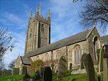
| St Andrew's Church, Stratton | |
|---|---|
 Stratton church | |
| Denomination | Church of England |
| History | |
| Dedication | St Andrew |
| Administration | |
| Parish | Bude-Stratton |
| Deanery | Stratton |
| Archdeaconry | Bodmin |
| Diocese | Truro |
| Province | Canterbury |
One of the most prominent buildings in Stratton is the 12th century Norman church dedicated to Saint Andrew which holds a central and elevated position within the town. It is listed Grade I. The church contains a brass to Sir John Arundell of Trerice, 1561.[6]
As well as the main church, there were also other chapels around the village; this indicates a large population because only one church wouldn’t suffice. This is also supported by the existence of the large, old tithe barn; it needed to be large enough to hold the tax of one-tenth of their earnings/produce that all villagers paid to the church. The area around Cot Hill was an important sanctuary for pilgrims travelling the pilgrimage route to Hartland during Medieval times. However, many of the chapels are derelict or have now been converted, suggesting the population decline has been so great as to leave only enough people to use the church and one remaining chapel.
Justice
The town once had a jail, a police station and a courthouse, but the police station has now been moved to Bude, the jail demolished and the courthouse converted into two dwellings. The door of the jail, marked "CLINK", is still visible in the church porch. The following quotation indicates Stratton's importance as a centre of justice "As Stratton Town and the surrounding villages grew, the need to administer civil and criminal law from an appropriate location was necessary."[7]
Government
The name Stratton was given to the unit of government for taxation during Saxon times, known as a ‘Hundred’. Stratton was the head of its hundred due to its importance in comparison to that of the local towns and villages, including Kilkhampton, Marhamchurch, Boyton, Jacobstow, Whitstone, Stratton itself, Poughill, Bridgerule, Week St Mary, Launcells, North Tamerton and Morwenstow. Other than the loss of Bridgerule, the Stratton Hundred remained undisturbed until the demise of the Stratton Rural District in the 1970s.
The Hundred is an indicator of Stratton’s importance not only for these reasons, but also because in the whole of Cornwall, there were only nine Hundreds and all of them had their own courts, this suggests that not only did Stratton have a courthouse, it was probably the only one in the Stratton Hundred. (At the time of Domesday Book there were only seven hundreds: the hundred of Trigg was later divided into Trigg, Lesnewth and Stratton. Stratton manor was the head manor of Trigg hundred in Domesday Book.)
Trade and industry

Trade and industry greatly affected Stratton’s popularity; it had a thriving leather and agricultural trade. During medieval times it dealt in leather, evidence of this is the road named after the trade; Poundfield area was where the animals were kept, Stratton also housed tanning pits and a rack park, where the leather was stretched. There is also evidence of farming in the milking parlours, barns and stalls that are made from cob, a traditional building material, and the Old Malt House shows where ale was produced in the church owned brewery. During medieval times herbs and spices were also considered important, for medicinal purposes as well as others, and Stratton was famous for having an abundance of wild garlic.
Trade events such as markets and fairs were a regular occurrence in Stratton and people would come from all around to attend. Lots of the evidence for events and trades in Stratton is subtle, for example street names like Market Street and Poundfield Lane. Stratton had up to 14 pubs, although some were houses where people brewed beer themselves. Many have now been knocked down or converted, however some, for example the Tree Inn, are still running, despite perhaps fewer customers than they would have expected before Bude became the main town. Although many of the shops that once lined the streets have now been converted into homes, the large front windows still hint at the lives led by the inhabitants when Stratton was the most important town in the area.
19th and 20th centuries
Trade directories allow us to compare the two towns, for example, in 1844, when Stratton had six shoemakers, Bude had only one, although Slater’s Trade Directory 1852-1853 shows the period in which Bude was beginning to catch up, although Stratton was still thriving. One of the main factors which led to the demise of Stratton’s influence was New Road which directed traffic away from the centre of Stratton in the early 20th century. The bypass was then built in 1950 when Stratton was well and truly defeated. Following the 1960s rail closures Stratton and Bude became the two towns most remote from the rail network in England. Despite the downfall of Stratton, it still managed to keep the hospital and surgery running although the union and workhouse from the 1830s was no longer operating.
See also
References
- ↑ 1643: Civil War in the South-West The British Civil Wars & Commonwealth website
- ↑ A similar saying is current at Saltash about Plymouth.
- ↑ Charter S 1507 at the Electronic Sawyer
- ↑ Weatherhill, Craig (2009) A Concise Dictionary of Cornish Place-names. Westport, Co. Mayo: Evertype; p. 65
- ↑ Thorn, Caroline, et al. (eds.) Cornwall. Chichester: Phillimore; entry 5,1,3
- ↑ Dunkin, E. (1882) Monumental Brasses. London: Spottiswoode
- ↑ Bill Young & Bryan Dudley Stamp (2002) Stratton Past & Present. Bude: Bill Young ISBN 0-9532669-4-X
Further reading
- Bere, Rennie & Stamp, Bryan Dudley (1980) The Book of Bude and Stratton. Buckingham: Barracuda Books ISBN 0-86023-055-4
- Peachey, Stuart (1993) The Battle of Stratton 1643. Stuart Press ISBN 1-85804-018-3
External links
| Wikimedia Commons has media related to Stratton, Cornwall. |
Cornwall Portal | |
| Unitary authorities | |
| Major settlements |
|
| Rivers | |
| Topics | |