Carcoforo
| Carcoforo | |
|---|---|
| Comune | |
| Comune di Carcoforo | |
 Carcoforo Location of Carcoforo in Italy | |
| Coordinates: 45°54′N 8°3′E / 45.900°N 8.050°ECoordinates: 45°54′N 8°3′E / 45.900°N 8.050°E | |
| Country | Italy |
| Region | Piedmont |
| Province / Metropolitan city | Province of Vercelli (VC) |
| Area | |
| • Total | 22.8 km2 (8.8 sq mi) |
| Population (Dec. 2004) | |
| • Total | 78 |
| • Density | 3.4/km2 (8.9/sq mi) |
| Time zone | CET (UTC+1) |
| • Summer (DST) | CEST (UTC+2) |
| Postal code | 13026 |
| Dialing code | 0163 |
Carcoforo is a comune (municipality) in the province of Vercelli in the Italian region Piedmont, located about 100 kilometres (62 mi) northeast of Turin and about 70 kilometres (43 mi) northwest of Vercelli. As of 31 December 2004, it had a population of 78 and an area of 22.8 square kilometres (8.8 sq mi).[1]
Carcoforo borders the following municipalities: Bannio Anzino, Ceppo Morelli, Fobello, Macugnaga, Rima San Giuseppe, and Rimasco.
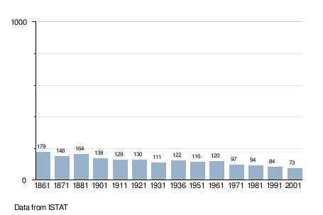
Demographic evolution
References
This article is issued from Wikipedia - version of the 1/31/2015. The text is available under the Creative Commons Attribution/Share Alike but additional terms may apply for the media files.