Postua
| Postua | |
|---|---|
| Comune | |
| Comune di Postua | |
|
The village behind the old bridge on the Strona | |
 Postua Location of Postua in Italy | |
| Coordinates: 45°43′N 8°14′E / 45.717°N 8.233°ECoordinates: 45°43′N 8°14′E / 45.717°N 8.233°E | |
| Country | Italy |
| Region | Piedmont |
| Province / Metropolitan city | Province of Vercelli (VC) |
| Area | |
| • Total | 16.6 km2 (6.4 sq mi) |
| Population (Dec. 2004) | |
| • Total | 568 |
| • Density | 34/km2 (89/sq mi) |
| Demonym(s) | Postuesi |
| Time zone | CET (UTC+1) |
| • Summer (DST) | CEST (UTC+2) |
| Postal code | 13010 |
| Dialing code | 015 |

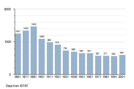
Postua is a comune (municipality) in the Province of Vercelli in the Italian region Piedmont, located about 80 kilometres (50 mi) northeast of Turin and about 45 kilometres (28 mi) northwest of Vercelli. As of 31 December 2004, it had a population of 568 and an area of 16.6 square kilometres (6.4 sq mi).[1]
Geography
Postua borders the following municipalities: Ailoche, Borgosesia, Caprile, Guardabosone, Scopa, and Vocca.
Demographics
References
External links
![]() Media related to Postua at Wikimedia Commons
Media related to Postua at Wikimedia Commons
This article is issued from Wikipedia - version of the 10/9/2014. The text is available under the Creative Commons Attribution/Share Alike but additional terms may apply for the media files.