Carnation, Oregon
| Carnation | |
|---|---|
| Unincorporated community | |
|
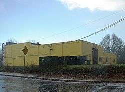
Building in the area | |
 Carnation  Carnation Location within the state of Oregon | |
| Coordinates: 45°30′27″N 123°06′09″W / 45.50750°N 123.10250°WCoordinates: 45°30′27″N 123°06′09″W / 45.50750°N 123.10250°W | |
| Country | United States |
| State | Oregon |
| County | Washington |
| Time zone | Pacific (PST) (UTC-8) |
| • Summer (DST) | PDT (UTC-7) |
Carnation is an unincorporated community in Washington County, Oregon, United States. Carnation lies on Oregon Route 47 on the south side of Forest Grove. The community had its own post office from 1905 to 1906 and again from 1914 to around 1933.[1] The area is part of the Forest Grove Rural Fire Protection District.[2]
References
- ↑ Benson, Robert L. (October 19, 1976). "Business and Industry: Post offices, zip codes listed". Hillsboro Argus. p. 11.
- ↑ "County Bridges & Fire District Boundaries." (PDF). Washington County. Retrieved June 23, 2014.
External links
- A condensed history - Forest Grove News-Times
Municipalities and communities of Washington County, Oregon, United States | ||
|---|---|---|
| Cities | 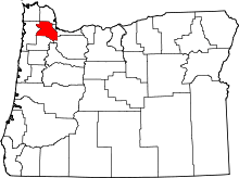 | |
| CDPs | ||
| Unincorporated communities |
| |
| Ghost towns | ||
| Footnotes | ‡This populated place also has portions in an adjacent county or counties | |
This article is issued from Wikipedia - version of the 11/15/2016. The text is available under the Creative Commons Attribution/Share Alike but additional terms may apply for the media files.