Manning, Oregon
| Manning | |
|---|---|
| Unincorporated community | |
|
Sign and highway in Manning | |
 Manning  Manning Location within the state of Oregon | |
| Coordinates: 45°39′54″N 123°9′45″W / 45.66500°N 123.16250°WCoordinates: 45°39′54″N 123°9′45″W / 45.66500°N 123.16250°W | |
| Country | United States |
| State | Oregon |
| County | Washington |
| Time zone | Pacific (PST) (UTC-8) |
| • Summer (DST) | PDT (UTC-7) |
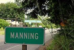

Manning is an unincorporated community in Washington County, Oregon, United States on the Sunset Highway (U.S. Route 26/Oregon Route 47). The Banks–Vernonia State Trail, a rail trail conversion, passes through Manning and has a trail head. The NorthWest POINT offers twice-daily roundtrip intercity bus service between Portland and Astoria with a flag stop in Manning.[1]
History
Manning was named for Martin Manning, who took up a land claim there in 1865.[2] Manning post office was established in 1890.[2] In 1954, the community joined with neighboring Buxton and Banks to form the Tri-City Rural Fire Protection District (now Banks Fire District).[3] The Manning school, part of the Banks School District, closed in 1987.[4]
References
- ↑ http://www.northwest-point.com/
- 1 2 McArthur, Lewis A.; Lewis L. McArthur (2003) [1928]. Oregon Geographic Names (Seventh ed.). Portland, Oregon: Oregon Historical Society Press. p. 608. ISBN 0-87595-277-1.
- ↑ "History". Banks Fire District. Retrieved 17 March 2016.
- ↑ Hill, Jim (August 30, 1987). "Banks district awaits Sept. 15 mail vote on $3.5 million school-bond measure". The Oregonian. p. MW B7.
External links
-
 Media related to Manning, Oregon at Wikimedia Commons
 - Manning history from VanNatta Forestry
Municipalities and communities of Washington County, Oregon, United States | ||
|---|---|---|
| Cities | 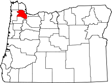 | |
| CDPs | ||
| Unincorporated communities |
| |
| Ghost towns | ||
| Footnotes | ‡This populated place also has portions in an adjacent county or counties | |