Carterville, Montana
| Carterville, Montana | |
|---|---|
| Unincorporated community | |
 Carterville, Montana  Carterville, Montana | |
| Coordinates: 46°17′58″N 106°28′03″W / 46.29944°N 106.46750°WCoordinates: 46°17′58″N 106°28′03″W / 46.29944°N 106.46750°W | |
| Country | United States |
| State | Montana |
| County | Rosebud |
| Elevation | 2,503 ft (763 m) |
| Time zone | Mountain (MST) (UTC-7) |
| • Summer (DST) | MDT (UTC-6) |
| Area code(s) | 406 |
| GNIS feature ID | 769633[1] |
Carterville (or Cartersville) is an unincorporated community in Rosebud County, Montana, United States.[1]
History
A post office called Cartersville was established in 1909, and remained in operation until it was discontinued in 1957.[2] The community was named for Thomas H. Carter, a United States Senator from Montana who owned land there.[3]
Notable people
- James Muri, United States World War II pilot[4]
Notes
- 1 2 "Carterville, Montana". Geographic Names Information System. United States Geological Survey.
- ↑ "Rosebud County". Jim Forte Postal History. Archived from the original on 11 May 2006. Retrieved 27 April 2015.
- ↑ "Origins of Names on Milwaukee". Roundup Record-Tribune & Winnett Times. August 22, 1940. p. 6. Retrieved 27 April 2015.
- ↑ James Muir
Municipalities and communities of Rosebud County, Montana, United States | ||
|---|---|---|
| Cities | 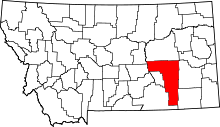 | |
| CDPs | ||
| Other unincorporated communities | ||
| Indian reservation | ||
| Ghost town | ||
| Footnotes | ‡This populated place also has portions in an adjacent county or counties | |
This article is issued from Wikipedia - version of the 11/16/2016. The text is available under the Creative Commons Attribution/Share Alike but additional terms may apply for the media files.