Carthage Township, Athens County, Ohio
| Carthage Township, Athens County, Ohio | |
|---|---|
| Township | |
|
U.S. Route 50/State Route 32 just south of Guysville | |
 Location of Carthage Township in Athens County | |
| Coordinates: 39°14′16″N 81°53′39″W / 39.23778°N 81.89417°WCoordinates: 39°14′16″N 81°53′39″W / 39.23778°N 81.89417°W | |
| Country | United States |
| State | Ohio |
| County | Athens |
| Area | |
| • Total | 38.6 sq mi (100.0 km2) |
| • Land | 38.5 sq mi (99.8 km2) |
| • Water | 0.08 sq mi (0.2 km2) |
| Elevation[1] | 860 ft (262 m) |
| Population (2010) | |
| • Total | 1,532 |
| • Density | 40/sq mi (15.3/km2) |
| Time zone | Eastern (EST) (UTC-5) |
| • Summer (DST) | EDT (UTC-4) |
| FIPS code | 39-12336[2] |
| GNIS feature ID | 1085753[1] |

Carthage Township is one of the fourteen townships of Athens County, Ohio, United States. The 2010 census found 1,532 people in the township.[3]
Geography
Located in the southeastern part of the county, it borders the following townships:
- Rome Township - north
- Troy Township - east
- Olive Township, Meigs County - southeast corner
- Orange Township, Meigs County - south
- Bedford Township, Meigs County - southwest corner
- Lodi Township - west
- Canaan Township - northwest corner
No municipalities are located in Carthage Township, although the unincorporated community of Lottridge lies in the township's center.
Name and history
Carthage Township was organized in 1819.[4]
It is the only Carthage Township statewide.
Government
The township is governed by a three-member board of trustees, who are elected in November of odd-numbered years to a four-year term beginning on the following January 1. Two are elected in the year after the presidential election and one is elected in the year before it. There is also an elected township fiscal officer,[5] who serves a four-year term beginning on April 1 of the year after the election, which is held in November of the year before the presidential election. Vacancies in the fiscal officership or on the board of trustees are filled by the remaining trustees.
References
- 1 2 "US Board on Geographic Names". United States Geological Survey. 2007-10-25. Retrieved 2008-01-31.
- ↑ "American FactFinder". United States Census Bureau. Archived from the original on 2013-09-11. Retrieved 2008-01-31.
- ↑ "Geographic Identifiers: 2010 Demographic Profile Data (G001): Carthage township, Athens County, Ohio". U.S. Census Bureau, American Factfinder. Retrieved July 10, 2013.
- ↑ Walker, Charles Manning (1869). History of Athens County, Ohio, And, Incidentally, of the Ohio Land Company and the First Settlement of the State at Marietta. Robert Clarke & Company. p. 451.
- ↑ §503.24, §505.01, and §507.01 of the Ohio Revised Code. Accessed 4/30/2009.
External links
Municipalities and communities of Athens County, Ohio, United States | ||
|---|---|---|
| Cities | 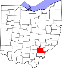 | |
| Villages | ||
| Townships | ||
| CDPs | ||
| Unincorporated communities | ||
| Footnotes | ‡This populated place also has portions in an adjacent county or counties | |