Casalgrande
| Casalgrande | |
|---|---|
| Comune | |
| Comune di Casalgrande | |
|
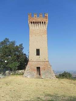
The castle of Dinazzano | |
 Casalgrande Location of Casalgrande in Italy | |
| Coordinates: 44°35′N 10°44′E / 44.583°N 10.733°ECoordinates: 44°35′N 10°44′E / 44.583°N 10.733°E | |
| Country | Italy |
| Region | Emilia-Romagna |
| Province / Metropolitan city | Province of Reggio Emilia (RE) |
| Frazioni | Boglioni, Casalgrande Alto, Dinazzano, Salvaterra, San Donnino di Liguria, Sant'Antonino-Veggia, Villalunga |
| Government | |
| • Mayor | Andrea Rossi (Partito Democratico) |
| Area | |
| • Total | 37.7 km2 (14.6 sq mi) |
| Elevation | 97 m (318 ft) |
| Population (Dec. 2004) | |
| • Total | 15,933 |
| • Density | 420/km2 (1,100/sq mi) |
| Demonym(s) | Casalgrandesi |
| Time zone | CET (UTC+1) |
| • Summer (DST) | CEST (UTC+2) |
| Postal code | 42013 |
| Dialing code | 0522, 0536 |
| Website | Official website |
Casalgrande is a comune (municipality) in the Province of Reggio Emilia in the Italian region Emilia-Romagna, located about 50 kilometres (31 mi) west of Bologna and about 15 kilometres (9 mi) southeast of Reggio Emilia. As of 31 December 2004, it had a population of 15,933 and an area of 37.7 square kilometres (14.6 sq mi).[1]
The municipality of Casalgrande contains the frazioni (subdivisions, mainly villages and hamlets) Boglioni, Casalgrande Alto, Dinazzano, Salvaterra, San Donnino di Liguria, Sant'Antonino-Veggia and Villalunga.
Casalgrande borders the following municipalities: Castellarano, Formigine, Modena, Reggio Emilia, Rubiera, Sassuolo, Scandiano.
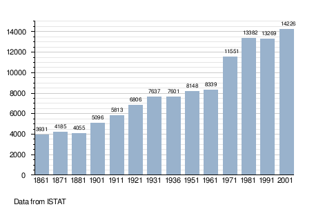
Demographic evolution
References
External links
![]() Media related to Casalgrande at Wikimedia Commons
Media related to Casalgrande at Wikimedia Commons
This article is issued from Wikipedia - version of the 11/29/2016. The text is available under the Creative Commons Attribution/Share Alike but additional terms may apply for the media files.