Ligonchio
| Ligonchio | |
|---|---|
| Comune | |
| Comune di Ligonchio | |
 Ligonchio Location of Ligonchio in Italy | |
| Coordinates: 44°19′N 10°20′E / 44.317°N 10.333°ECoordinates: 44°19′N 10°20′E / 44.317°N 10.333°E | |
| Country | Italy |
| Region | Emilia-Romagna |
| Province / Metropolitan city | Province of Reggio Emilia (RE) |
| Frazioni | Caprile, Casalino, Cinquecerri, Montecagno, Ospitaletto, Piolo, Vaglie |
| Area | |
| • Total | 61.7 km2 (23.8 sq mi) |
| Population (Dec. 2004) | |
| • Total | 976 |
| • Density | 16/km2 (41/sq mi) |
| Time zone | CET (UTC+1) |
| • Summer (DST) | CEST (UTC+2) |
| Postal code | 42039 |
| Dialing code | 0522 |
| Website | Official website |
Ligonchio is a comune (municipality) in the Province of Reggio Emilia in the Italian region Emilia-Romagna, located about 80 kilometres (50 mi) west of Bologna and about 50 kilometres (31 mi) southwest of Reggio Emilia. As of 31 December 2004, it had a population of 976 and an area of 61.7 square kilometres (23.8 sq mi).[1]
The municipality of Ligonchio contains the frazioni (subdivisions, mainly villages and hamlets) Caprile, Casalino, Cinquecerri, Montecagno, Ospitaletto, Piolo, and Vaglie.
Ligonchio borders the following municipalities: Busana, Collagna, Sillano, Villa Minozzo.
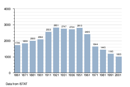
Demographic evolution
References
External links
This article is issued from Wikipedia - version of the 1/31/2015. The text is available under the Creative Commons Attribution/Share Alike but additional terms may apply for the media files.