Castione della Presolana
| Castione della Presolana | |
|---|---|
| Comune | |
| Comune di Castione della Presolana | |
|
Town hall | |
 Castione della Presolana Location of Castione della Presolana in Italy | |
| Coordinates: 45°54′N 10°2′E / 45.900°N 10.033°ECoordinates: 45°54′N 10°2′E / 45.900°N 10.033°E | |
| Country | Italy |
| Region | Lombardy |
| Province / Metropolitan city | Province of Bergamo (BG) |
| Frazioni | bratto - dorga |
| Government | |
| • Mayor | Mauro Pezzoli |
| Area | |
| • Total | 42.6 km2 (16.4 sq mi) |
| Highest elevation | 2,521 m (8,271 ft) |
| Lowest elevation | 870 m (2,850 ft) |
| Population (Dec. 2004) | |
| • Total | 3,379 |
| • Density | 79/km2 (210/sq mi) |
| Demonym(s) | Castionesi |
| Time zone | CET (UTC+1) |
| • Summer (DST) | CEST (UTC+2) |
| Postal code | 24020 |
| Dialing code | 0346 |
| Patron saint | Alessandro |
| Saint day | 26 agosto |
| Website | www.presolana.it |
.jpg)
Castione della Presolana is a comune (municipality) in the Province of Bergamo in the Italian region of Lombardy, located about 80 kilometres (50 mi) northeast of Milan and about 35 kilometres (22 mi) northeast of Bergamo. As of 31 December 2004, it had a population of 3,379 and an area of 42.6 square kilometres (16.4 sq mi).[1]
Castione della Presolana borders the following municipalities: Angolo Terme, Colere, Fino del Monte, Onore, Rogno, Rovetta, Songavazzo.
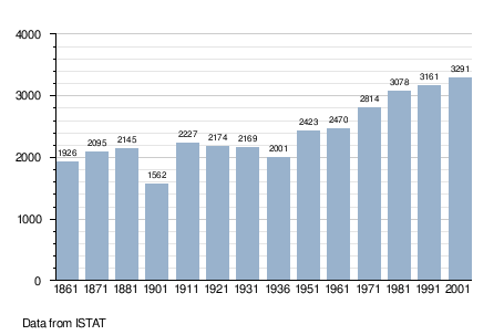
Demographic evolution
Twin towns — Sister cities
Castione della Presolana is twinned with:
-
 Bons-en-Chablais, France
 -
 Adenau, Germany
References
This article is issued from Wikipedia - version of the 8/16/2016. The text is available under the Creative Commons Attribution/Share Alike but additional terms may apply for the media files.