Castledawson
| Castledawson | |
| Irish: An Seanmhullach | |
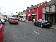 Castledawson Main Street |
|
 |
|
| Population | 3,293 (2001 Census) |
|---|---|
| – Belfast | 35 mi (56 km) |
| District | Magherafelt |
| County | County Londonderry |
| Country | Northern Ireland |
| Sovereign state | United Kingdom |
| Post town | MAGHERAFELT |
| Postcode district | BT45 |
| Dialling code | 028 |
| Police | Northern Ireland |
| Fire | Northern Ireland |
| Ambulance | Northern Ireland |
| EU Parliament | Northern Ireland |
| UK Parliament | Mid Ulster |
| NI Assembly | Mid Ulster |
|
|
Coordinates: 54°46′41″N 6°33′22″W / 54.778°N 6.556°W
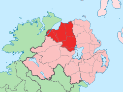
Castledawson is a village in County Londonderry, Northern Ireland. It is mostly within the townland of Shanemullagh (from Irish an Seanmhullach, meaning "the old hilltop"),[1] about four miles from the north-western shore of Lough Neagh, and near the market town of Magherafelt. At the 2011 Census it had a population of 3,293.
History
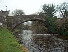
The village sits on the River Moyola and was originally called "Dawson's Bridge". The bridge that crossed the river here was once the largest single span stone bridge in Ireland. The village was named after its 'castle' (actually a large manor house) built by Joshua Dawson in 1713. He was Chief Secretary for Ireland and founded the village in 1710. The Dawson estate, Shanemullagh, shares its name with the original townland name. The Dawson family also founded Christ Church, on the edge of that estate, in the early 18th century.
On 12 July 1830, Orange Institution parades led to confrontations between Orangemen and Ribbonmen in Maghera and Castledawson. Several Catholic homes were then burnt by Protestants following these clashes.[2]
Castledawson was the hub of the mid Ulster shirt-making industry, with its location midway between Belfast and Derry being crucial. In 1943, Nestlé built and opened a factory that made sweetened condensed milk. However, it was closed in the 1970s. Today it is the home of the award-winning Ditty's Bakery and Moyola Precision Engineering, a noted innovator of aerospace components.
The River Moyola, which dissects the village, is popular with anglers and has managed stocks of salmon (but also has perch, eel, trout and bream). Dominating the horizon to the south-west of the village is a dramatic ráth.
People

Famous natives have included:
- James Chichester-Clark, a direct descendant of the Dawsons, who was the Prime Minister of Northern Ireland from 1969 to 1971.
- The poet Seamus Heaney, who was awarded the 1995 Nobel Prize in Literature, was born at a farm near Castledawson in 1939, and was brought up in the nearby village of Bellaghy.
- Novelist Anne Dunlop, was born and raised near Castledawson.
- American military history author, John McCann, was born and raised in Castledawson. His book Passing Through: The 82nd Airborne Division In Northern Ireland 1943-44 chronicles the town's World War II past.
- Marian Donnelly, former President of the Workers' Party, was born in Castledawson in 1938.
- The singer-songwriter and producer Ciaran Gribbin.
Transport
Castledawson railway station opened on 10 November 1856, closed for passenger traffic on 28 August 1950, and finally closed altogether on 1 October 1959.[3]
The main A6 Belfast to Derry road passed through Castledawson until 1992, when it was bypassed.
Education
- Castledawson Primary School
- New Row Primary School
Sport
Castledawson is home to the association football club Moyola Park, the Gaelic Athletic Association club St Malachys G.A.C. Castledawson and the eighteen hole Moyola golf club.
2011 Census
According to the 2011 Census, Castledawson has 3,329 residents. 53.44% of the Castledawson ward were Catholic, while 43.47% were Protestant.[4]
In terms of National Identity, 8 choices were provided and the breakdown is as follows[5]
| Northern Ireland Census 2011 | |
| National Identity | % |
|---|---|
| British only | 38.45% |
| Irish only | 27.04% |
| Northern Irish only | 24.48% |
| British and Irish only | 0.27% |
| British and Northern Irish only | 4.18% |
| Irish and Northern Irish only | 2.01% |
| British, Irish and Northern Irish only | 0.39% |
| Other | 3.18% |
References
- ↑ Placenames NI
- ↑ "Parades and Marches - Chronology 2: Historical Dates and Events". Conflict Archive on the Internet (CAIN). Retrieved 28 January 2010.
- ↑ "Castledawson station" (PDF). Railscot - Irish Railways. Retrieved 2007-09-15.
- ↑ 2011 Census for Northern Ireland
- ↑ Culture Northern Ireland
| Wikimedia Commons has media related to Castledawson. |