Ballykelly, County Londonderry
| Ballykelly | |
| Irish: Baile Uí Cheallaigh | |
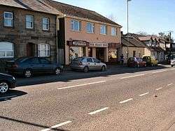 The village centre, located on the A2 |
|
 Ballykelly |
|
| Population | 1,836 (2001 Census) |
|---|---|
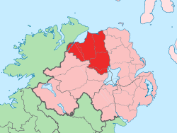
| District | Causeway Coast and Glens |
| County | County Londonderry |
| Country | Northern Ireland |
| Sovereign state | United Kingdom |
| Post town | LIMAVADY |
| Postcode district | BT49 |
| Dialling code | 028 |
| Police | Northern Ireland |
| Fire | Northern Ireland |
| Ambulance | Northern Ireland |
| EU Parliament | Northern Ireland |
| UK Parliament | East Londonderry |
|
|
Coordinates: 55°02′40″N 7°00′57″W / 55.0445°N 7.01576°W
Ballykelly (from Irish: Baile Uí Cheallaigh, meaning "O'Kelly's Townland"[1]) is a village and townland in County Londonderry, Northern Ireland. It lies 3 miles (4.8 km) west of Limavady on the main Derry to Limavady A2 road and is 15 miles (24 km) east of Derry. It is designated as a Large Village and in 2001 the population of Ballykelly (excluding Walworth) was 1,827.[2] It lies within Causeway Coast and Glens district.
Features
Ballykelly contains some of the most interesting buildings erected in Ulster by the Plantation companies, being largely developed by the London Company of Fishmongers through the 18th and 19th centuries. It features Tamlaghtfinlagan Parish Church, built by Earl Frederick Hervey, 18th-century Bishop of Derry, amongst many traditional buildings. The Presbyterian Church, Drummond Hotel and North West Independent Hospital, were all built by the London Company of Fishmongers.[3] The village enjoys views across Lough Foyle to Inishowen in County Donegal[4] and is bordered by Ballykelly Forest which was the first State Forest in Northern Ireland. Although there are good health and educational facilities available, there is only a limited retail sector relative to the population of the village.[2]
Politics
The village lies within the East Londonderry constituency and is represented by Democratic Unionist Party (DUP) member, Gregory Campbell.
History
The village was originally laid out as a Plantation settlement. The development of the nearby World War II airfield greatly enhanced the size and significance of the village. There has been considerable expansion throughout the post-War period, particularly since the 1990s, with a series of private residential developments west of the historic core along Clooney Road.[2]
RAF Ballykelly opened in 1941 as an airfield RAF Coastal Command and closed in 1971, because of the British Government's defence cuts. The station was transferred to the British Army, who renamed it Shackleton Barracks. The Army was due to leave Shackleton Barracks in early 2008. During World War II an RAF bomber aeroplane on a training run clipped a telephone line behind a church in Ballykelly and crashed, claiming the lives of the crew.[4] The aircraft was carrying out a trials mission involving low level parachuting, but a parachute became entangled with the tailplane, putting the aircraft out of control.
During the Northern Irish Troubles the Droppin Well bombing occurred in Ballykelly, killing 17 people in a local disco and bar. Although one of the most fatal single incidents of the conflict, it was the only fatal Troubles-related incident to take place in Ballykelly.
Places of interest
- Ballykelly Forest is located west of the village. Also known as the Camman Wood, it was a popular haunt for highwaymen terrorising the coach road from Coleraine to Derry.[5] The land was purchased in 1910 and it became the first state forest in Northern Ireland, with the planting of 11 acres (4.5 ha) of Douglas fir commencing in 1912. It now has walking trails.[6]
- Between Limavady and Ballykelly is Rough Fort, one of the best preserved earthworks in the province. It covers approximately 1 acre (0.40 ha) was one of the first properties to be acquired by the National Trust in Northern Ireland.[7]
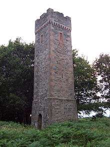
- Nearby is Sampson's Tower, a fortified structure built by public subscription in memory of Arthur Sampson who for 40 years was an agent of the London Worshipful Company of Fishmongers.
- The village hosts Shackleton Barracks, which became famous when a commercial airliner on a Ryanair service landed there by mistake on 29 March 2006, instead of at City of Derry Airport.[8]
Demography
Ballykelly is classified as a village by the NI Statistics and Research Agency (NISRA) (i.e., with a population of between 1,000 and 2,250 people). On Census day (29 April 2001) there were 1,836 people living in Ballykelly. Of these:
- 27.8% were aged under 16 and 11.3% were aged 60 and over
- 49.6% of the population were male and 50.4% were female
- 59.6% were from a Catholic background and 39.0% were from a Protestant background
- 6.9% of people aged 16–74 were unemployed.
For more details see: NI Neighbourhood Information Service
Climate
| Climate data for Ballykelly | |||||||||||||
|---|---|---|---|---|---|---|---|---|---|---|---|---|---|
| Month | Jan | Feb | Mar | Apr | May | Jun | Jul | Aug | Sep | Oct | Nov | Dec | Year |
| Average high °C (°F) | 6 (43) |
7 (44) |
9 (49) |
12 (53) |
15 (59) |
17 (63) |
18 (65) |
18 (65) |
16 (61) |
13 (55) |
9 (48) |
7 (45) |
12 (54) |
| Average low °C (°F) | 2 (35) |
2 (35) |
3 (37) |
4 (39) |
6 (43) |
9 (48) |
11 (52) |
11 (51) |
9 (49) |
7 (44) |
4 (39) |
3 (37) |
6 (42) |
| Average precipitation mm (inches) | 81 (3.2) |
53 (2.1) |
48 (1.9) |
48 (1.9) |
53 (2.1) |
69 (2.7) |
91 (3.6) |
81 (3.2) |
81 (3.2) |
84 (3.3) |
74 (2.9) |
91 (3.6) |
856 (33.7) |
| Source: Weatherbase [9] | |||||||||||||
Transport
- Ballykelly has good road links to Derry and Limavady. A proposed Ballykelly by-pass would, when constructed, provide a 7 kilometres (4.3 mi) single carriageway road taking the bulk of through traffic away from the village.[2] Construction is now "on hold until 2020".[10]
- The City of Derry Airport is 9 km (5.6 mi) to the west.
- The Broharris Canal was constructed in the 1820s when a 2 miles (3.2 km) long cut was made on the south shore of Lough Foyle near Ballykelly in the direction of Limavady. It served both as a drainage channel and for transport with goods being brought from Londonderry Port, as well as shellfish and kelp from the sand banks along the shore.
- Ballykelly railway station opened on 29 December 1852 and closed on 20 September 1954.[11] There are currently no rail links serving Ballykelly, although the Derry to Belfast railway line runs nearby.
Sport
- Gaelic football is played at Glack GAC which encompasses players from Ballykelly and the Glack area.
- Camogie is also played at Glack GAC for ladies.
- The Nedd CC is the local cricket team in Ballykelly, and currently play in Senior League 2 of the North West Cricket Union.
Education
- Ballykelly Primary School
- St. Finlough's Primary School, Glack, Ballykelly
Religion

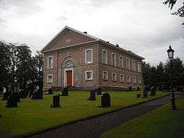
The Anglican parish of Tamlaghtfinlagan originally was located 1-mile (1.6 km) southwest of the current village. The village is recorded in Papal Bulls of the mid-12th century. The name Tamlaghtfinlagan comes from the Irish for "the resting place of Finliganus", one of Columba's monks who was, according to tradition, the founding abbot of the abbey. This abbey building still exists, although in ruins. In the mid-16th century the parish church moved to Walworth. In 1689 it was gutted by the retreating troops of James II following the defeat in the Battle of the Boyne. The current edifice was dedicated in 1795, and is a simple perpendicular church, with three aisles, a small chancel and a gallery, much of which was built by the Worshipful Company of Fishmongers.
- Ballykelly Presbyterian Church was built in 1827 by the Fishmongers Company, London and is a listed grade A building. It has a growing congregation of over 240 families.[12]
- Saint Finlough's Catholic Church dates from 1849.[13]
People
- Novelist William Makepeace Thackeray travelled through the village during his Irish tour in 1842. He wrote about the Presbyterian Church, championing its architecture over the "sham-Gothic ecclesiastical edifices" which were apparently in Ireland at the time.[4]
| Wikimedia Commons has media related to Ballykelly, County Londonderry. |
References
- ↑ Placenames Database of Ireland
- 1 2 3 4 "Ballykelly Settlement Designation". Planning Service - Draft Northern Area Plan 2016. Retrieved 2008-06-21.
- ↑ "Ballykelly". Causeway Borough Council. Retrieved 2008-06-21.
- 1 2 3 http://www.bbc.co.uk/northernireland/yourplaceandmine/londonderry/ballykelly_village.shtml
- ↑ "Ballykelly Forest". Walk Northern Ireland. Retrieved 2008-06-21.
- ↑ "Ballykelly Forest". Forest Service. Retrieved 2008-06-21.
- ↑ "Limavady Borough Council - Attractions : Limavady town, Dungiven and Ballykelly, Northern Ireland". Limavady.gov.uk. Retrieved 2014-08-14.
- ↑ "BBC News Northern Ireland". Plane lands at airbase by mistake. 2006-03-29. Retrieved 2007-01-24.
- ↑ "Weatherbase: Historical Weather for Ballykelly, Northern Ireland". Weatherbase. 2011. Retrieved on November 24, 2011.
- ↑ "A2 Ballykelly Bypass". Northern Ireland Roads Site. Archived from the original on 5 July 2008. Retrieved 2008-06-21.
- ↑ "Ballykelly station" (PDF). Railscot - Irish Railways. Archived (PDF) from the original on 26 September 2007. Retrieved 2007-09-11.
- ↑ "Ballykelly | Presbyterian Church Ireland". Presbyterianireland.org. Retrieved 14 August 2014.
- ↑