Catawba River

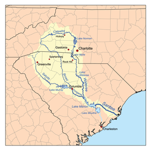
The Catawba River (named after the Native American tribes that first settled on the banks) originates in Western North Carolina and the name of the river changes to the Wateree River in South Carolina. The river is approximately 220 miles (350 km) long. It rises in the Appalachian Mountains and drains into Piedmont, and is impounded through a series of reservoirs for flood control and hydroelectricity. The river is named after the Catawba tribe of Native Americans. In their Siouan language, they identified as the Kawahcatawbas, "the people of the river".
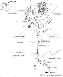
It rises in the Blue Ridge Mountains in western McDowell County, North Carolina, approximately 20 miles (30 km) east of Asheville. It flows ENE, forming, along with the Linville River, Lake James. It then passes north of Morganton, then southeast through Lake Hickory just north of Hickory, NC, and into the Lake Norman reservoir. From Lake Norman it flows south, passing west of Charlotte, then flowing through the Mountain Island Lake and Lake Wylie reservoirs, where it forms approximately 10 miles (15 km) of the border between North Carolina and South Carolina, also the confluence of the South Fork Catawba River and Catawba River is submerged by Lake Wylie near the NC/SC state line. It flows into northern South Carolina, passing Rock Hill, then through Fishing Creek Reservoir near Great Falls, and then into the Lake Wateree reservoir, approximately 30 miles (50 km) northeast of Columbia. At the now-submerged confluence with Wateree Creek, it becomes the Wateree River.
Dams


The Catawba is heavily dammed, including the following:
North Carolina
- Lake James Dam
- Rhodhiss Dam
- Oxford Dam
- Lookout Shoals Dam
- Cowans Ford Dam, creating Lake Norman
- Mountain Island Lake Dam
South Carolina
- Lake Wylie Dam in India Hook
- Fishing Creek Reservoir in Great Falls
- Dearborn-Great Falls Dam
- Cedar Creek Reservoir Dam
- Lake Wateree Dam
Controversy
In 2006 the river became the center of a water use controversy between the residents of the Catawba watershed and Cabarrus County, North Carolina. The cities of Concord and Kannapolis are expecting a daily shortfall of 22 million US gallons (83,000 m3) of water a day by 2035 [1] and want to pump up to 36 million US gallons (140,000 m3) of water daily from the Catawba.[2] The Concord/Kannapolis Interbasin Transfer (IBT) proposal calls for water to be permanently transferred from one river basin to another river basin. Such a transfer is unlike the more common water usage, in which municipalities within the Catawba basin pump water from the river and treat it for residential use. Much of that treated water eventually returns to the Catawba River.
Though neither Concord nor Kannapolis are located in the Catawba River basin (both are located in the Pee Dee River basin), the cities said the Catawba River is a regional resource. Opponents of the IBT argued that towns and cities along the Catawba River basin are growing as well, and that the cities' request is too large.
On January 10, 2007, the North Carolina state environmental panel authorized Concord and Kannapolis to pump up to 10 million US gallons (38,000 m3) a day from the Catawba River. This decision represented a compromise recommended by hearing officers for the Environmental Management Commission. The mayors of Morganton and Valdese stated they were adamantly against the transfer and that the panel's ruling was skewed and biased.[3] Concord's city manager stated the approval of the water transfer was "bittersweet", since the panel authorized an amount much lower than was originally requested and is likely to be delayed by lawsuits. “Well, (officials from) Hickory are going to file an appeal,” said Concord Mayor Scott Padgett, who spoke briefly with Hickory Mayor Rudy Wright after the EMC meeting. “His major concern is changing the (interbasin transfer) process. My appeal to him is that there should be a truce. To file an appeal is just going to prolong something we deserve, is less than what we asked for and is going to further hard feelings this has already created.” [4]
The controversy ended in early 2010 when all the parties reached a settlement that further limits the amount of water available to Concord and Kannapolis under drought conditions.
A river at risk
Starting in the early autumn months of 2007 the Catawba basin, along with large swaths of the Southern United States, began to feel the effects of an extreme drought. On October 15, 2007, the Morganton News Herald reported that North Carolina Governor Mike Easley described the drought as "the worst in recorded history".[5]
On January 29, 2008, Duke Energy, the utility responsible for managing the Catawba River, extended its estimated time frame for Stage 4 water restrictions to August. The extension was possible because of conservation measures and the 6 inches of rain the basin received in December. However, area leaders converged on Valdese to hear presentations from Representatives of the N.C. Rural Center, N.C. Department of Commerce, N.C. Department of Environment and Natural Resources and the Appalachian Regional Commission about grants and loans that are available to help pay for solutions to the drought.[6]
In April 2008 the environmental group American Rivers named the Catawba-Wateree River "the most endangered river in America." [7] Reasons cited for the river's condition are the drought, the presence of 11 hydroelectric dams, global warming, and unchecked development along its banks.[8]
On June 11, 2008, South Carolina Governor Mark Sanford signed legislation denoting the Catawba as a state scenic river. The designation carries no land-use restrictions, but it allows the state to convene an advisory group to address river-related concerns.
On June 29, 2009, the EPA announced that four of the top 44 "High Hazard Ash Ponds" in the United States are on the Catawba River. Two ash ponds are adjacent to and discharge into Mountain Island Lake. The EPA High Hazard list also includes ash ponds on Lake Wylie and Lake Norman.[9]
On December 11, 2014, Duke Energy received approval from North Carolina to dump coal ash (containing arsenic, lead, thallium and mercury, among other heavy metals) from the Marshall Steam Station into Lake Norman to repair a rusted, leaking pipe.[10] Groundwater at the Marshall Steam Station does flow toward Lake Norman, and the contaminated field abuts the lake for about 30 feet of shoreline near its largest coal ash basin.[11]
On October 3, 2015, Duke reported that a sinkhole had formed at the base of the Marshall Steam Station dam north of Charlotte on Lake Norman. The Department of Environmental Quality (DEQ) says Duke placed a liner in the hole and filled it with crushed stone.[12]
The Catawba River basin is one of only four areas left in the southeast with significant populations of Hymenocallis coronaria, the Shoals spider-lily. It has one large population left at Landsford Canal State Park.[13]
Crossings
The Catawba River is crossed by many highways over its course. (Note: this list may be incomplete)
North Carolina
- Lake James to Lake Norman
- Power House Road
- Watermill Glen Alpine Road
- Independence Blvd in Morganton
- N Green Street (N.C. 181) in Morganton
- U.S. 64 in Morganton
- Huffman Bridge
- Castle Bridge near Rutherford College
- Rhodhiss Road in Rhodhiss
- U.S. 321 in Hickory
- N.C. 127 near Hickory
- N.C. 16 below Oxford Dam
- Interstate 40
- Hudson Chapel Road in Catawba
- US 70 in Catawba
- Buffalo Shoals Road over Lake Norman
- N.C. 150 over Lake Norman
- Lake Norman to the SC border
- N.C. 73 bridge at Cowans Ford Dam
- Rozzelle Bridge on Brookshire Blvd (N.C. 16) over Mountain Island Lake
- E. Charlotte Avenue in Mount Holly
- Interstate 85
- Wilkinson Blvd U.S. 29 and U.S. 74 in Belmont
- Buster Boyd Bridge over Lake Wylie
South Carolina
- Lake Wylie to Lake Wateree
See also
References
- ↑ "Whose Water Is It?". The News Herald. Retrieved 2008-02-22.
- ↑ "Political hot potato for region's water users". Mooresville Tribune. Retrieved 2008-02-22.
- ↑ "Panel Opens Up Catawba River". News Harald. Retrieved 2008-02-22.
- ↑ "Water transfer approved". The Independent Tribune. Retrieved 2008-02-22.
- ↑ "Gov: Drought worse in recorded history". Morganton News Herald. Retrieved 2008-02-22.
- ↑ "Small reprieve comes in drought, towns still preparing". The Morganton News Herald. Retrieved 2008-02-22.
- ↑ "America's 10 Most Endangered Rivers 2008". Environment News Service. Retrieved 2008-04-20.
- ↑ "Defending the Catawba: Biggest threat is lack of sensible land-use planning". Charlotte Observer/Charlotte.com. Retrieved 2008-04-20.
- ↑ "EPA Coal Ash Fact Sheet". EPA/EPA.gov. Retrieved 2009-11-19.
- ↑ http://www.hickoryrecord.com/news/duke-to-repair-leaky-pipe-at-coal-ash-dump-in/article_2bd33b10-8185-11e4-989c-e347c5127e28.html
- ↑ http://www.bizjournals.com/charlotte/blog/energy/2015/09/duke-energy-completes-groundwater-contamination.html
- ↑ http://www.bizjournals.com/charlotte/blog/energy/2015/10/weekend-storm-impacts-dams-at-duke-energy-coal.html?ana=e_du_pub&s=article_du&ed=2015-10-05&u=jFGEoJyeJYHFwZ4W/oMBM4H/9NF&t=1444074616
- ↑ Markwith, Scott H.; Scanlon, Michael J. (May 11, 2006). "Multiscale analysis of Hymenocallis coronaria (Amaryllidaceae) genetic diversity, genetic structure, and gene movement under the influence of unidirectional stream flow". American Journal of Botany. Botanical Society of America. Retrieved October 1, 2012.
External links
Coordinates: 34°28′1″N 80°53′20″W / 34.46694°N 80.88889°W