Cattawade Marshes
| Site of Special Scientific Interest | |
 | |
| Area of Search |
Essex Suffolk |
|---|---|
| Grid reference | TM090329 |
| Interest | Biological |
| Area | 88.2 hectares |
| Notification | 1988 |
| Location map | Magic Map |
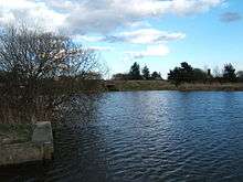
Cattawade Marshes is an 88.3 hectare biological Site of Special Scientific Interest between East Bergholt and Manningtree in Essex and Suffolk.[1][2] It is managed by the Royal Society for the Protection of Birds.[3] It is a Ramsar wetland of international importance,[4] and part of the Stour and Orwell Special Protection Area, and the Dedham Vale Area of Outstanding Natural Beauty[5]
The site is a marsh area between two arms of the River Stour. It is of major importance for breeding birds, especially waders and wildfowl, such as Shoveler, Teal, Tufted Duck and Water Rail. Other habitats are grassland and ditches.[1][3]
There is no public access but the site can be viewed from a public footpath on the south side of the river.[3]
| Wikimedia Commons has media related to Cattawade Marshes. |
References
- 1 2 "Cattawade Marshes citation" (PDF). Sites of Special Scientific Interest. Natural England. Retrieved 6 December 2015.
- ↑ "Map of Cattawade Marshes". Sites of Special Scientific Interest. Natural England. Retrieved 6 December 2015.
- 1 2 3 "Cattawade Marshes". Royal Society for the Protection of Birds. Retrieved 6 December 2015.
- ↑ "Cattawade Marshes". Natural England. Retrieved 6 December 2015.
- ↑ "Dedham Vale AONB and Stour Valley – Management Plan 2010-2015" (PDF). Dedham Vale Area of Outstanding Natural Beauty and Stour Valley Project. p. 21. Retrieved 4 December 2015.
Coordinates: 51°57′23″N 1°02′54″E / 51.9564°N 1.0483°E