Foulness SSSI
| Site of Special Scientific Interest | |
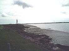 View across the River Roach | |
| Area of Search | Essex |
|---|---|
| Grid reference | TR030905 |
| Interest | Biological |
| Area | 10,702 hectares |
| Notification | 1993 |
| Location map | Magic Map |
Foulness SSSI is a 10,702 hectare biological Site of Special Scientific Interest covering the shoreline between Southend-on-Sea and the Crouch estuary in Essex. It is a key site in A Nature Conservation Review,[1][2] and is part of the Essex Estuaries Special Area of Conservation.[3] It covers two Ramsar wetland sites of international importance, 'Crouch and Roach Estuaries' and 'Foulness'.[4] An area of 6.4 hectares is Shoeburyness Old Ranges, a Local Nature Reserve[5][6] managed by the Essex Wildlife Trust.[7]
Most of the site is owned and managed by the Ministry of Defence. Natural England describes it as "extensive intertidal sand-silt flats, saltmarsh, beaches, grazing marshes, rough grass and scrubland". The flats are of international importance for nine species of wildfowl and waders, such as dark-bellied brent geese. Rare plants include soft hornwort and spiral tasselwood, and the site is also important for invertebrates, with 71 nationally rare species.[1]
| Wikimedia Commons has media related to Foulness SSSI. |
References
- 1 2 "Foulness citation" (PDF). Sites of Special Scientific Interest. Natural England. Retrieved 24 February 2016.
- ↑ "Map of Foulness". Sites of Special Scientific Interest. Natural England. Retrieved 24 February 2016.
- ↑ "Essex Estuaries". Joint Nature Conservation Committee. Retrieved 24 February 2016.
- ↑ "Designated and Proposed Ramsar sites in the UK and Overseas Territories & Crown Dependencies". Joint Nature Conservation Committee. Retrieved 24 February 2016.
- ↑ "Shoeburyness Old Ranges". Local Nature Reserves. Natural England. Retrieved 24 February 2016.
- ↑ "Map of Shoeburyness Old Ranges". Local Nature Reserves. Natural England. Retrieved 24 February 2016.
- ↑ "Gunners Park and Shoebury Ranges Nature Reserve". Essex Wildlife Trust. Retrieved 24 February 2016.
Coordinates: 51°34′52″N 0°56′13″E / 51.581°N 0.937°E