Cave Spring, Georgia
| Cave Spring, Georgia | |
|---|---|
| City | |
|
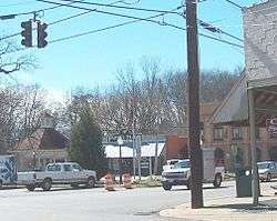
Downtown Cave Spring | |
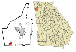 Location in Floyd County and the state of Georgia | |
| Coordinates: 34°6′32″N 85°20′10″W / 34.10889°N 85.33611°WCoordinates: 34°6′32″N 85°20′10″W / 34.10889°N 85.33611°W | |
| Country | United States |
| State | Georgia |
| County | Floyd |
| Area | |
| • Total | 4.07 sq mi (10.53 km2) |
| • Land | 4.05 sq mi (10.49 km2) |
| • Water | 0.02 sq mi (0.04 km2) |
| Elevation | 640 ft (195 m) |
| Population (2010) | |
| • Total | 1,200 |
| • Density | 296/sq mi (114.4/km2) |
| Time zone | Eastern (EST) (UTC-5) |
| • Summer (DST) | EDT (UTC-4) |
| ZIP code | 30124 |
| Area code(s) | 706/762 |
| FIPS code | 13-14108[1] |
| GNIS feature ID | 0355041[2] |
| Website |
www |
Cave Spring is a city in Floyd County, Georgia, United States. It is located 16 miles (26 km) southwest of Rome, the county seat. The population of Cave Spring was 1,200 at the 2010 census,[3] up from 975 at the 2000 census. It is part of the Rome, Georgia Metropolitan Statistical Area.
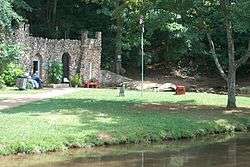
The town was named after the cave and water spring located in Rolater Park.[4] The cave has impressive stalagmites and the legendary "Devil's Stool" formation. The spring water has won awards for purity and taste. Many visitors bring jugs to fill at the spring and take home for drinking.
Geography
Cave Spring is located in southwestern Floyd County at 34°6′32″N 85°20′10″W / 34.10889°N 85.33611°W (34.108912, -85.336018).[5] U.S. Route 411 passes through the city, leading northeast to Rome and west 46 miles (74 km) to Gadsden, Alabama. The Alabama border is 5 miles (8 km) west of Cave Spring. Georgia State Route 100 leads north from Cave Spring 12 miles (19 km) to Coosa and southeast 11 miles (18 km) to Cedartown.
According to the United States Census Bureau, the city of Cave Spring has a total area of 4.1 square miles (10.5 km2), of which 0.02 square miles (0.04 km2), or 0.36%, is water.[3]
History
Cave Spring is well known for the natural wonders of the cave and spring site where indigenous peoples came to the area (both Cherokee and the earlier Mississippian culture). Legend has it that tribal meetings and games used to be held at the site. In 1839, Cave Spring was formed as a small town, founded by Baptists who were among the early settlers. The cave and spring site is now part of Rolater Park, formerly used by educational institutions such as Cave Spring Manual Labor School (renamed Hearn Academy) and others including Georgia School for the Deaf. During the Atlanta Campaign of the Civil War in 1864, both Confederate and Union troops came to Cave Spring for hospitalization and rest.
The spring flows into a sparkling pond from Rolater Park and then into a 1.5-acre (6,100 m2) swimming pool shaped like the state of Georgia. The pool is constructed out of stones.
Cave Spring has historic homes and buildings from its early years, such as the 1867 Presbyterian Church, 1880 train depot, and 19th century hotels and boarding houses.
Demographics
| Historical population | |||
|---|---|---|---|
| Census | Pop. | %± | |
| 1880 | 835 | — | |
| 1890 | 952 | 14.0% | |
| 1900 | 824 | −13.4% | |
| 1910 | 805 | −2.3% | |
| 1920 | 738 | −8.3% | |
| 1930 | 723 | −2.0% | |
| 1940 | 982 | 35.8% | |
| 1950 | 959 | −2.3% | |
| 1960 | 1,153 | 20.2% | |
| 1970 | 1,305 | 13.2% | |
| 1980 | 883 | −32.3% | |
| 1990 | 950 | 7.6% | |
| 2000 | 975 | 2.6% | |
| 2010 | 1,200 | 23.1% | |
| Est. 2015 | 1,175 | [6] | −2.1% |
As of the census[1] of 2000, there were 975 people, 404 households, and 281 families residing in the city. The population density was 242.7 people per square mile (93.6/km²). There were 431 housing units at an average density of 107.3 per square mile (41.4/km²). The racial makeup of the city was 84.82% White, 12.41% African American, 0.62% Native American, 0.10% Pacific Islander, 1.44% from other races, and 0.62% from two or more races. Hispanic or Latino of any race were 2.15% of the population.
There were 404 households out of which 28.2% had children under the age of 18 living with them, 52.0% were married couples living together, 14.9% had a female householder with no husband present, and 30.2% were non-families. 29.5% of all households were made up of individuals and 15.3% had someone living alone who was 65 years of age or older. The average household size was 2.36 and the average family size was 2.89.
In the city the population was spread out with 23.7% under the age of 18, 5.1% from 18 to 24, 23.8% from 25 to 44, 24.5% from 45 to 64, and 22.9% who were 65 years of age or older. The median age was 44 years. For every 100 females there were 83.3 males. For every 100 females age 18 and over, there were 75.5 males.

The median income for a household in the city was $33,750, and the median income for a family was $47,917. Males had a median income of $35,395 versus $20,962 for females. The per capita income for the city was $17,850. About 14.0% of families and 15.1% of the population were below the poverty line, including 22.6% of those under age 18 and 13.9% of those age 65 or over.
Georgia School for the Deaf
Cave Spring is the home of the Georgia School for the Deaf, established in 1846. It is a state-funded residential school operating under the auspices of the Office of Special Services of the Georgia State Department of Education and the Georgia State Board of Education. It aims to ensure that appropriate educational programs are available for hearing impaired and multi-handicapped hearing impaired students residing in Georgia. GSD was once a field hospital for both Confederate and Union troops during the Civil War.
References
- 1 2 "American FactFinder". United States Census Bureau. Archived from the original on 2013-09-11. Retrieved 2008-01-31.
- ↑ "US Board on Geographic Names". United States Geological Survey. 2007-10-25. Retrieved 2008-01-31.
- 1 2 "Geographic Identifiers: 2010 Census Summary File 1 (G001), Cave Spring city, Georgia". American FactFinder. U.S. Census Bureau. Retrieved April 27, 2016.
- ↑ "Floyd County". Calhoun Times. September 1, 2004. p. 57. Retrieved 24 April 2015.
- ↑ "US Gazetteer files: 2010, 2000, and 1990". United States Census Bureau. 2011-02-12. Retrieved 2011-04-23.
- ↑ "Annual Estimates of the Resident Population for Incorporated Places: April 1, 2010 to July 1, 2015". Retrieved July 2, 2016.
- ↑ "Census of Population and Housing". Census.gov. Archived from the original on May 11, 2015. Retrieved June 4, 2015.
External links
Municipalities and communities of Floyd County, Georgia, United States | ||
|---|---|---|
| Cities | 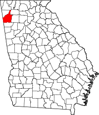 | |
| CDPs | ||
| Unincorporated communities | ||