Cedar Slope, California
| Cedar Slope, California | |
|---|---|
| census-designated place | |
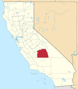
 Cedar Slope, California Position in California. | |
| Coordinates: 36°08′37″N 118°34′38″W / 36.14361°N 118.57722°WCoordinates: 36°08′37″N 118°34′38″W / 36.14361°N 118.57722°W | |
| Country |
|
| State |
|
| County | Tulare |
| Area[1] | |
| • Total | 0.695 sq mi (1.80 km2) |
| • Land | 0.695 sq mi (1.80 km2) |
| • Water | 0 sq mi (0 km2) 0% |
| Elevation[2] | 5,584 ft (1,702 m) |
| Population (2010) | |
| • Total | 0 |
| • Density | 0/sq mi (0/km2) |
| Time zone | Pacific (PST) (UTC-8) |
| • Summer (DST) | PDT (UTC-7) |
| GNIS feature ID | 2585406 |
| U.S. Geological Survey Geographic Names Information System: Cedar Slope, California | |
Cedar Slope is a census-designated place (CDP) in Tulare County, California.[2] Cedar Slope sits at an elevation of 5,584 feet (1,702 m).[2] The 2010 United States census reported that Cedar Slope was uninhabited.[3]
Geography
According to the United States Census Bureau, the CDP covers an area of 0.7 square miles (1.8 km²), all of it land.
References
This article is issued from Wikipedia - version of the 11/19/2016. The text is available under the Creative Commons Attribution/Share Alike but additional terms may apply for the media files.