Central Milton Keynes
| Central Milton Keynes | |
 View from Great Holm, approximately one mile to the west |
|
 Central Milton Keynes |
|
| Area | 0.9 sq mi (2.3 km2) |
|---|---|
| Population | 2,726 (2011 Census)[1] |
| – density | 3,029/sq mi (1,170/km2) |
| OS grid reference | SP851389 |
| Civil parish | Central Milton Keynes |
| Unitary authority | Milton Keynes |
| Ceremonial county | Buckinghamshire |
| Region | South East |
| Country | England |
| Sovereign state | United Kingdom |
| Post town | MILTON KEYNES |
| Postcode district | MK9 |
| Dialling code | 01908 |
| Police | Thames Valley |
| Fire | Buckinghamshire |
| Ambulance | South Central |
| EU Parliament | South East England |
| UK Parliament | Milton Keynes North |
| Website | centralmk-tc.gov.uk |
|
|
Coordinates: 52°02′32″N 0°45′35″W / 52.0423°N 0.7598°W
Central Milton Keynes is the central business district of Milton Keynes, Buckinghamshire, England and a civil parish in its own right, designated as a town council.
The district is approximately 2.5 km long by 1 km wide and occupies some of the highest land in Milton Keynes. It contains (behind the Central Library) the historic site of the moot hill for Secklow or Sigelai Hundred. It contains the central retail, business, law enforcement and governmental districts, Milton Keynes Central railway station and around 2000 residential dwellings.
This area is known locally as "the city centre".[2][3]
Topology
Occupying 238 hectares (590 acres),[4] the area lies between Portway (H5, A509) to the north, the West Coast Main Line and A5 to the west, Childs Way (H6) to the south and Marlborough Street (V8, B4034) to the east. It is crossed from north to south by (in west to east order, major roads only) Grafton Gate (V6), Witan Gate, Saxon Gate (V7) and Secklow Gate. It is crossed from west to east (in north to south order, major roads only) by Silbury Boulevard, Midsummer Boulevard and Avebury Boulevard. Midsummer Boulevard is the primary spine. (Campbell Park, stretching from Marlborough Street down to the Grand Union Canal, is sometimes included in loose definitions of CMK, though in fact it is part of a separate civil parish. It is included in the area known as Central Milton Keynes for the purposes of planning and development).
East of Saxon Gate: the main retail/service/entertainment district
This area is almost the highest[5] point of Milton Keynes and includes the site of the moot mound (meeting place) for the Anglo-Saxon Secklow Hundred just behind the library.
The area is defined by Marlborough Street (V8, B4034) to the north-east, the Saxon Gate (Saxon Street, V7) to the south-west, Portway (H5, A509) to the north-west and Childs Way (H6) to the south-east. The core retail district is further delimited by Silbury and Avebury Boulevards, with civic and office developments outside the Boulevards.
The retail district includes thecentre:mk and Midsummer Place (the covered high streets that are the Central Milton Keynes Shopping Centres). The Library, Milton Keynes Borough Council civic offices and other commercial offices are on the north side of the shops; the theatre, art gallery, Theatre District, Xscape (see below), pubs, sports shops and other leisure facilities are on the south side.
Xscape
Xscape is the main leisure complex in Central Milton Keynes consisting of SnoZone, a real snow indoor ski slope, climbing wall and a multiscreen cinema, and a number of shops, restaurants and night clubs. At the rear of the site is Airkix, the first publicly available indoor skydiving tunnel in the UK.[6]
Milton Keynes Theatre and Gallery
The 1,400 seat Milton Keynes theatre/concert hall has an unusual feature: the ceiling can be lowered closing off the third tier (gallery) to create a more intimate space for smaller scale productions. It is the most successful regional theatre in the UK outside of London and operated by the Ambassador Theatre Group.
Milton Keynes Gallery (the municipal art gallery, beside the main theatre) does not have a permanent collection. This allows it to host edgy shows to critical acclaim.[7]
West of Saxon Gate, east of Grafton Gate: the main business district

This area is also delimited by Portway and Childs Way. Saxon Gate separates it from the north-east area and Grafton Gate (Grafton Street, V7) marks its south-western edge. The domed Church of Christ the Cornerstone, law courts and police station are in the business district, which has a number of notable buildings including CBX (central business exchange), The Hub:MK and the purpose-built Indian restaurant called Jaipur beside the small linear Grafton Park that provides its core. The restaurant claims to be the largest purpose-built Indian restaurant in Europe.
Ecumenical Church of Christ the Cornerstone
This ecumenical church, the first such in the United Kingdom, is shared by the major Christian denominations to serve the office workers and the small resident population. (There are many denominational places of worship throughout the town at large).
The Hub:MK
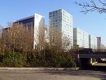
The Hub:MK is a 2006-built development between the station and the church, consisting of towers ranging between 10 and 14 stories. The complex includes two high-rise hotels and a number of residential and office towers set around a central piazza. The site controversially involves the closure of one of the original pedestrian underpasses and is built right up to the edge of the adjacent boulevard, the first of several proposals that would have changed the unique character of Milton Keynes Development Corporation's original design for Central Milton Keynes. The work is part of the 'densification' plan that central government, through its agency English Partnerships, had ordained for Milton Keynes. Its height, also a major departure from the original low-rise design, makes it the third tallest building in Milton Keynes, beaten only by the 14-storey Xscape and the 18-storey Mellish Court in Bletchley.
To the south of the Hub lies a similar development named Vizion. This is similar in height and layout to the Hub but features a large Sainsburys supermarket taking up the lower two floors with a rooftop garden above it. Vizion was completed in 2009, whilst the following year saw the completion of the 9-story Pinnacle office development further west along Midsummer Boulevard from the Hub, closer to the railway station. The latter is distinctive for the slanted roof on its tallest section.
West of Grafton Gate: the station district
This district is defined by Saxon Gate (Saxon Street, V7) to the north-east, the West Coast Main Line (and the adjacent A5) to the south-west, Portway (H5, A509) to the north-west and Childs Way (H6) to the south-east. The core retail district is further delimited by Silbury and Avebury Boulevards, with civic and office developments outside the Boulevards.
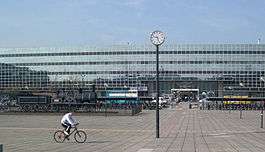
The main feature of the district is the Milton Keynes Central railway station (an inter-city stop on the West Coast Main Line), one of the five[8] stations serving Milton Keynes. Coach services operate from here as well as from the Milton Keynes coachway next to junction 14 of the M1 motorway. Services include the Stagecoach X5 service that replaces the Varsity Line, which links Milton Keynes with Oxford in the west (for connections to the west and Wales) and Cambridge in the east; and the 99 service to Luton Airport, operated by Stagecoach on behalf of Virgin Rail. The station building houses commercial office lets and food outlets, and the Station Square development includes further office lets and retail outlets.
The bus interchange bays are located at the railway station forecourt. (The former central bus station is located opposite the railway station but has not been operating as such since 1997. The upstairs level of the bus station (formerly a night club) accommodates a young peoples' facility, 'the Buszy'. This includes an award winning covered "urban" skate-boarding area, which has attracted international 'skaters' and film crews).
The former England National Hockey Stadium was located on a site to the north of the station, surrounded by a number of important retail units. Having been vacated, this was demolished in early 2010 and the site redeveloped as 'the 'Quadrant:MK', the national 'centre' for Network Rail.[9] To its south there is another leisure and retail area – the Leisure Plaza, notably the Planet Ice Arena (home of Milton Keynes Lightning) and what was another ten-pin bowling alley. Closed for redevelopment since 2013, this facility is expected to reopen in Autumn 2014.[10]
Civil parish
Central Milton Keynes is a civil parish, bordering (clockwise from north) Great Linford, Campbell Park, Loughton, and Bradwell.[11] The parish was created in 2001, and had a population of 1,272 according to the 2001 census.[12]
ONS Urban sub-area
For the 2001 Census, the Office for National Statistics designated an urban sub-area (map) that it called "Central Milton Keynes". This was far bigger than either the district or the parish. It consisted of that part of Milton Keynes that is west of the River Ouzel, but north of the Bletchley urban sub-area (which approximates to the former Bletchley Urban District), south-east of the Wolverton/Stony Stratford urban sub-area (which approximates to the former Wolverton Urban District) and south of its North Milton Keynes urban sub-area. (The provenance of "North Milton Keynes", and of its boundary with the Central Milton Keynes urban sub-area, are unclear. The Central Milton Keynes and North Milton Keynes urban sub-areas together approximate to that part of the former Newport Pagnell Rural District that is west of the River Ouzel). For the 2011 Census, this nomenclature has disappeared.
Media
Locations around Central Milton Keynes were used for the movie Superman IV: The Quest for Peace, where it played the part of the United Nations building. Recognisable locations include Milton Keynes Central, CBX and the Argos (now Home retail Group) building on Avebury Boulevard.[13]
See also
- Milton Keynes for a more general description of the amenities of the wider area.
- Central Milton Keynes Shopping Centre
- Milton Keynes Central railway station
- Milton Keynes Village
References
- ↑ Neighbourhood Statistics 2011 census, Accessed 3 February 2013
- ↑ Plans revealed for new £30m multi-storey car park in central Milton Keynes – Milton Keynes Citizen
- ↑ Milton Keynes does not have City status in the United Kingdom and remains formally a town. However it was planned to be a city in scale and the term 'town' is reserved locally for its constituent and adjacent towns – Bletchley, Stony Stratford, Wolverton, Newport Pagnell, Woburn Sands – and Central Milton Keynes.
- ↑ Borough of Milton Keynes: parish profiles
- ↑ Oakhill, at the western border with Aylesbury Vale, is slightly higher.
- ↑ "Out and About". www.roomsmiltonkeynes.co.uk. Retrieved 26 August 2015.
- ↑ Guardian Unlimited | Search |"Milton keynes gallery"
- ↑ Bletchley, Bow Brickhill, Fenny Stratford, Milton Keynes Central, and Wolverton
- ↑ Network Rail opens The Quadrant:MK The Railway Gazette, 1 June 2012
- ↑ Arena information Planet Ice
- ↑ Parishes in Milton Keynes – Milton Keynes Council. Archived 8 June 2009 at the Wayback Machine.
- ↑ 1.6MB PDF Parishes A-L
- ↑ Filming Locations for Superman IV
External links
| Wikimedia Commons has media related to Central Milton Keynes. |