Chachani
| Chachani | |
|---|---|
| Cachani[1] | |
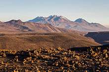
 The summit (on the left) and the path leading to it in October 2007 | |
| Highest point | |
| Elevation | 6,057 m (19,872 ft) [2] |
| Prominence | 1,963 m (6,440 ft) [2] |
| Listing | Ultra |
| Coordinates | 16°11′39″S 71°31′54″W / 16.19417°S 71.53167°WCoordinates: 16°11′39″S 71°31′54″W / 16.19417°S 71.53167°W [2] |
| Geography | |
 Chachani Location in Peru | |
| Location | Arequipa, Peru |
| Parent range | Andes |
| Geology | |
| Mountain type | Stratovolcano |
| Volcanic belt | Central Volcanic Zone |
| Last eruption | Unknown |
| Climbing | |
| Easiest route | Scramble with possible snow or ice |
Chachani is the highest of the mountains near the city of Arequipa in southern Peru.
As a result of the very low precipitation in the Arequipa area, Chachani does not have a permanent ice cap or glaciers. Climbing Chachani is popular, and many tour agencies in Arequipa offer guided trips to the summit, though the altitude is considered highly challenging for those who are not fully acclimatized.
Geology
Between six and eight separate craters form the massif of Chachani. Erosion has only left one recognizable crater in the western part of the complex.[3] This structure has an arcuate shape.[1] A shield 1 kilometre (0.62 mi) thick with a diametre of 8 kilometres (5.0 mi) is formed from coalescent lava flows on Chachani's southern side and is known as Pampa de Palacio or Las Cortaderas.[1] An escarpment on the eastern side of Chachani may be part of a "Chachani" caldera, the source of several ignimbrites in the Arequipa area.[4] Vegetation cover above 4,500 metres (14,800 ft) altitude is scarce.[5] Chachani is the eighty-four highest summit of the Andes.[6]
Chachani is largely Quaternary in origin,[7] Cerro Nocarane and the Penones lava dome predate the ice ages.[1] Activity of Chachani has migrated southward, from the Nocarane-Chingana volcanoes in the north to a complex of lava flows and lava domes in the south.[8] Volcanic activity in the area began as Tacaza volcanics during the Miocene. During the Sillapaca phase starting in the Pliocene the cone building volcanism took place. By its end explosive eruptions generated voluminous rhyolitic tuffs named sillar.[3]
Several ignimbrites in the Arequipa area appear to have been erupted from beneath Chachani. This includes the 18–20 cubic kilometres (4.3–4.8 cu mi) Arequipa Airport Ignimbrite and 16–24 cubic kilometres (3.8–5.8 cu mi) La Joya Ignimbrite. These Pliocene ignimbrites are dated 1.64 ± 0.07 mya and 4.87 ± 0.02 mya. The eruption of these ignimbrites would have left a caldera, now completely buried beneath the Chachani complex. The 1.02 ± 0.09 mya Rio Yura tuffs were probably erupted from beneath Nocarane.[4][9]
Later activity generated basaltic lava flows on Chachani's southwest side, in valleys eroded in the tuffs. There, the 1,200 metres (3,900 ft) high Pampa de Palacio/Las Cortaderas lava domes were formed by highly viscous andesitic lavas. They are well preserved, indicating a young age. It is believed the end of Chachani's eruptive activity happened simultaneously or closely preceded the start of activity of El Misti.[1][3] Some thin lava flows from the central and western parts of the volcano run above moraines. The Cerro La Horqueta cinder cone may be the youngest vent of Chachani.[1] Between 70,000 and 50,000 years ago ashfall deposits from El Misti were deposited on Chachani's southeastern flank.[10] A 270,000 ± 80,000 year old dacitic lava flow on Chachani's eastern flank is more likely to come from Chachani than El Misti, as are ash fall deposits found on top of this lava (which is thus older) and covering Chachani's flanks.[11] Geothermal activity is found today at Chachani,[12] and solfataras were observed in 2012 in the summit area.[6]
Two normal faults run beneath Chachani. Active El Misti, the extinct Pichupichu and possibly Ampato volcanoes are located along one of these fault zones. This fault zone has been active in the Holocene with a left-lateral offset. The formation of these volcanic centres may have been induced by the fault zone.[13][14]
The Pliocene ignimbrites contain biotite, ilmenite, magnetite, plagioclase, quartz, sanidine and sometimes amphibole.[9]
Pyroclastic flows and mudflows from Chachani are a potential threat to Arequipa, especially its western suburban area. Less than 25 kilometres (16 mi) separate it from the 3,000 metres (9,800 ft) higher Chachani.[1]
Glaciation
The volcano was glaciated during the Last Glacial Maximum (LGM) and then again during the Little Ice Age (LIA). There are no present day glaciers on Chachani.[8] The glaciation covered a large surface area in the past.[15]
Moraines from the LGM are found at 3,150–3,600 metres (10,330–11,810 ft) altitude and LIA moraines at 5,100–5,300 metres (16,700–17,400 ft) altitude.[8]
Ash and pumice reworked by water from El Misti have been found in probably glacially carved valleys on Chachani's southeastern side. This reworking may have happened between 24,000 and 12,000 years ago.[10]
Glacial erosion has left cirques and U-valleys on Chachani.[3]
Beneath rock walls, possibly active rock glaciers are found at altitudes 4,300–5,400 metres (14,100–17,700 ft) at Nocarane and 4,350–5,100 metres (14,270–16,730 ft) on Chachani.[8] On Nocarane, three different stages of rock glacier activity have been foun on the southern flank.[5]
Unlike on El Misti, permafrost has been found on Chachani.[15] Continuous permafrost covers a surface area of 16.8 square kilometres (6.5 sq mi) on Chachani, with a total area of 47.1 square kilometres (18.2 sq mi). The coverage starts at 5,050 metres (16,570 ft) altitude on the southern flank and coverage becomes continuous above 5,420 metres (17,780 ft).[5]
Climbing routes

The mountain is normally climbed from its northern side. The start of the trek is at a drop-off point which is reached in 2.5 hours by four-wheel drive vehicle, driving west around Chachani and turning off from the main highway near Pampa Cañahuas, or heading north from Arequipa between Misti and Chachani. Base camp is at approximately 5,200 metres (17,100 ft). There is another higher camp called Camp Azulfrera situated at about 5,400 metres (17,700 ft). The route starts with the ascent to the Angel Col before traversing the El Angel mountain itself. Then climbers ascend the face of Fatima mountain in a zig-zag pattern before making another traverse on the Fatima mountain. Only then the summit of Chachani can be seen. From there, climbers need to make the final ascent on the face of Chachani all the way to the top of the mountain.
The standard route requires crampons and an ice axe, but does not require roping up, as there are no large crevasses on Chachani. Two traverses over relatively steep terrain constitute the main challenges on the way to the summit. The final push to the summit is a very steep scree slope, which provides for a fast descent back to the first traverse.
In recent years, the amount of snow on Chachani has decreased dramatically, so for many months of the year there may be little snow on the mountain. For example, in October and November 2010, there was no snow at all, and the ascent could be made without crampons or ice axes. Climbers need to check on the snow conditions beforehand.
The average total climb time from base camp ranges from six to nine hours, with a two-to four-hour descent.
Human and religious activity
A Inca temple was constructed on Chachani's summit area, and archeological relics date back to pre-Hispanic times. This sanctuary was looted as early as the end of the 19th century. During one of these lootings, a skeleton of a woman, wooden vessels and ceramics. An archeological study in 2013 did suggest that Chachani's summit was the site of Capacocha sacrifices. Rock material from Chachani has been used to construct churches in Arequipa and sulfur was mined on the mountain. Oral tradition attributes to Chachani the ability to choose the gender of newborn children.[16]
See also
References
- 1 2 3 4 5 6 7 de Silva, SL; Francis, PW (March 1990). "Potentially active volcanoes of Peru-Observations using Landsat Thematic Mapper and Space Shuttle imagery". Bulletin of Volcanology. 52 (4): 286–301. doi:10.1007/BF00304100.
- 1 2 3 "Peru: 22 Mountain Summits with Prominence of 1,500 meters or greater" Peaklist.org. Retrieved 2012-04-18.
- 1 2 3 4 Bullard, Fred M. (December 1962). "Volcanoes of Southern Peru". Bulletin Volcanologique. 24 (1): 443–453. doi:10.1007/BF02599360.
- 1 2 Lebti, Perrine Paquereau; Thouret, Jean-Claude; Wörner, Gerhard; Fornari, Michel (June 2006). "Neogene and Quaternary ignimbrites in the area of Arequipa, Southern Peru: Stratigraphical and petrological correlations". Journal of Volcanology and Geothermal Research. 154 (3-4): 251–275. doi:10.1016/j.jvolgeores.2006.02.014.
- 1 2 3 ANDRÉS, NURIA; PALACIOS, DAVID; ÚBEDA, JOSE; ALCALÁ, JESÚS (September 2011). "GROUND THERMAL CONDITIONS AT CHACHANI VOLCANO, SOUTHERN PERU". Geografiska Annaler: Series A, Physical Geography. 93 (3): 151–162. doi:10.1111/j.1468-0459.2011.00424.x.
- 1 2 Gałaś, Andrzej; Panajew, Paweł; Cuber, Piotr (2014). "Stratovolcanoes in the Western Cordillera – Polish Scientifi c Expedition to Peru 2003–2012 reconnaissance research". Geotourism/Geoturystyka. 37 (2): 61. doi:10.7494/geotour.2014.37.61.
- ↑ Pallares, Carlos; Fabre, Denis; Thouret, Jean-Claude; Bacconnet, Claude; Charca-Chura, Juan Antonio; Martelli, Kim; Talon, Aurélie; Yanqui-Murillo, Calixtro (28 January 2015). "Geological and geotechnical characteristics of recent lahar deposits from El Misti volcano in the city area of Arequipa, South Peru". Geotechnical and Geological Engineering. 33 (3): 641–660. doi:10.1007/s10706-015-9848-x.
- 1 2 3 4 Alcalá, J.; Zamorano, J. J.; Palacios, D. "Volcanic and glacial evolution of Chachani-Nocarane complex (Southern Peru) deduced from the geomorphologic map.". The SAO/NASA Astrophysics Data System. EGU General Assembly 2012. Retrieved 28 February 2016.
- 1 2 Paquereau, P.; Roperch, P.; Fornari, M.; Wörner, G.; Thouret, J.-C. "Neogene ignimbrites in the area of Arequipa, southern Peru: correlations, flow directions and sources". The SAO/NASA Astrophysics Data System. EGS - AGU - EUG Joint Assembly, Abstracts from the meeting held in Nice, France. Retrieved 28 February 2016.
- 1 2 Thouret, Jean-Claude; Finizola, Anthony; Fornari, Michel; Legeley-Padovani, Annick; Suni, Jaime; Frechen, Manfred (December 2001). "Geology of El Misti volcano near the city of Arequipa, Peru". Geological Society of America Bulletin. 113 (12): 1593–1610. doi:10.1130/0016-7606(2001)113<1593:GOEMVN>2.0.CO;2.
- ↑ Legros, F (April 2001). "Tephra stratigraphy of Misti volcano, Peru". Journal of South American Earth Sciences. 14 (1): 15–29. doi:10.1016/S0895-9811(00)00062-6.
- ↑ DEGG, MARTIN R; CHESTER, DAVID K (June 2005). "Seismic and volcanic hazards in Peru: changing attitudes to disaster mitigation". The Geographical Journal. 171 (2): 125–145. doi:10.1111/j.1475-4959.2005.00155.x.
- ↑ Finizola, Anthony; Lénat, Jean-François; Macedo, Orlando; Ramos, Domingo; Thouret, Jean-Claude; Sortino, Francesco (August 2004). "Fluid circulation and structural discontinuities inside Misti volcano (Peru) inferred from self-potential measurements". Journal of Volcanology and Geothermal Research. 135 (4): 343–360. doi:10.1016/j.jvolgeores.2004.03.009.
- ↑ Birnie, R. W.; Hall, J. H. (March 1974). "The geochemistry of El Misti volcano, Peru fumaroles". Bulletin Volcanologique. 38 (1): 1–15. doi:10.1007/BF02597797.
- 1 2 Ubeda, Jose; Yoshikawa, Kenji; Pari, Walter; Palacios, David; Macias, Pablo; Apaza, Fredy; Ccallata, Beto; Miranda, Rafael; Concha, Ronald; Vasquez, Pool; Cruz, Rolando. "Geophysical surveys on permafrost in Coropuna and Chachani volcanoes (southern Peru)". The SAO/NASA Astrophysics Data System. EGU General Assembly 2015. Retrieved 28 February 2016.
- ↑ Ceruti, María Constanza (2013). "CHACHANI, MISTI Y PICHU PICCHU: PASADO Y PRESENTE DE LOS VOLCANES SAGRADOS DE AREQUIPA". Anuario de Arqueología (in Spanish). Universidad Nacional de Rosario. 5 (1): 359–372. ISSN 1852-8554. Retrieved 28 February 2016.
Sources
- "Nevado Chachani". Global Volcanism Program. Smithsonian Institution.
- Chachani on SummitPost
- "Nevado Chachani, Peru" on Peakbagger
- Chachani on Peakware