Coropuna
| Coropuna | |
|---|---|
 | |
| Highest point | |
| Elevation | 6,377 m (20,922 ft) [1] |
| Coordinates | 15°33′S 72°39′W / 15.550°S 72.650°WCoordinates: 15°33′S 72°39′W / 15.550°S 72.650°W [2] |
| Geography | |
 Coropuna | |
| Parent range | Andes |
| Geology | |
| Age of rock | Miocene-Holocene |
| Mountain type | Volcano |
| Volcanic arc | Central Volcanic Zone |
| Last eruption | 1,100 ± 100 BP[3] |
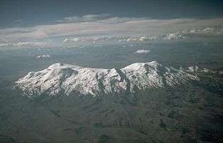
Coropuna is a dormant[4] volcano in the southern Peruvian Andes and belonging to the Central Volcanic Zone; its summit reaches an altitude of 6,377 metres (20,922 feet) above sea level.[1][5] The volcano, located 155 kilometres (96 miles) from Arequipa, is mostly made of lava flows on a basement formed by Miocene ignimbrites. Coropuna has been active for at least five million years, with the bulk of the current cone having formed during the Pliocene–Pleistocene.
The volcano is covered by a thick ice cap, the second largest in the tropics, that has existed since at least the Pliocene and has undergone several phases of expansion and reduction. As of 2016, the ice cap is in retreat; one estimate predicts that it will disappear by 2045. The retreat of the Coropuna glaciers threatens the water supply of tens of thousands of people, and interaction between volcanic activity and glacial effects has generated mudflows that could be a hazard to surrounding populations if the mountain returns to volcanic activity.
The mountain was considered sacred by the Inca, and a number of archaeological sites have been discovered there. The Inca built the highest irrigation system in the world on Coropuna.
Geography and geology
Part of the Cordillera Ampato,[6] it is Peru's largest and highest volcano.[7] Coropuna is located south of the Pucuncho basin in the Peruvian Andes[2] and 110 kilometres (68 mi) away from the Pacific coast.[8] Neighbouring volcanoes are the 5,498-metre (18,038 ft) Firura (15°14′S 72°48′W / 15.233°S 72.800°W) and the 6,093-metre (19,990 ft) Solimana (15°24′S 72°52′W / 15.400°S 72.867°W).[9] Firura is a structure with two dome shaped summits, while Solimana features a caldera and a high, glacially affected topography.[10] Another volcano, Ampato, lies 85 kilometres (53 mi) southeast.[11]
Ten summits, including four main ones, separated by broad saddles, form the Coropuna massif, which covers an area of 20×12 kilometres (12.4×7.5 mi) at 5,000 metres (16,000 ft) altitude.[9][12] Another description counts six main summits arranged in an ellipse.[11] Mapping of the volcano is made difficult by the ice cap.[7] The main summits are found in the western part of the massif, and two are aligned in a north–south direction with heights of 6,377 metres (20,922 ft) and 6,350 metres (20,830 ft). The eastern part features two summits: a central one has an ice-filled crater at 6,234 metres (20,453 ft), and the eastern one, at 6,305 metres (20,686 ft), is the summit that has generated the most recent lava flows.[13] Cerro Cuncaicha forms a spur on Coropuna's eastern flank.[14] All of these summits have a mostly smooth appearance.[15] The volcano developed in two phases: Coropuna I, at 4,200–5,000 metres (13,800–16,400 ft), has a conical shape; other summits, including Coropuna II, have grown above it.[13] The terrain of Coropuna has moderate slopes rising from a basement of 4,600 metres (15,100 ft).[16] Erosion has incised deep gorges around Coropuna.[13] The total volume of Coropuna is about 283 cubic kilometres (68 cu mi).[17]
Volcanism in the Andes originates in the collision of the Pacific Ocean floor with the South American Plate. This collision generates tectonic forces which lift up blocks of the Central Andes and create fissures through which magma reaches the surface.[18] Coropuna is part of the northern Central Volcanic Zone (CVZ)[9] and, along with Ampato–Sabancaya–Hualca Hualca, Chachani, and El Misti, forms part of the main volcanic arc .[19] Coropuna, Sara Sara, and Solimana are close to the northern border of the CVZ, where the Benioff zone becomes shallower.[20] In this area, the Andes mountains are still growing, and erosion has cut deep valleys into them.[12] The area also features numerous fault zones, best visible south and southwest of Coropuna where shifts of 10 metres (33 ft) and more have occurred. Coropuna lies on a line of volcanoes that runs from Solimana to Sabancaya.[7]
The bulk of the volcano was formed in the Quaternary, with activity commencing in the Miocene.[9] Five million years ago, the first latiandesites were erupted.[21] The minor eruptive centres of Pumaranra and Antapuna are K-Ar dated at 1.3 ± 0.11 and 1.02 ± 0.11 million years old.[22] Much of the volcano was constructed by lava flows.[12]
Volcanic history and future threat
Coropuna is constructed on Tertiary ignimbrites that form the Puna[8] (one of which is dated 14 million years[21]); these are completely buried around the volcano. The dates of these ignimbrites are not entirely clear.[12] The Barroso group beneath Coropuna is dated 5.3 million years by K-Ar.[23] Beginning in the mid-Pliocene, the Coropuna I and Coropuna II volcanoes were constructed by large lava flows. Of the former there remain only planezes, sectors that were once part of the volcano but are now separated by gaps created through erosion.[24] Evidence found in the Majes river valley indicates that volcanic activity frequently resulted in lahars when parts of the ice cap melted under the influence of volcanic activity.[25] Some explosive activity has thrown lava bombs up to 7 kilometres (4.3 mi) away.[26]
The bulk of the volcano was formed during the Pliocene and Pleistocene,[27] one tephra deposit being carbon-14 dated to 27,200–37,370 BP.[28] In the early Holocene, andesite lava flows overran late moraines.[9] Strong glacial and other erosion effects can be seen on Coropuna.[11] Chlorine-36 exposure dating has found ages of 6,000 years ago for the western lava flow and 2,000 years ago and less for the eastern lava flows.[29] These flows are tens of meters thick and 5–9 kilometres (3.1–5.6 mi) long and are only weakly eroded,[27] conserving most of their breccia cover.[30] Each of these lava emissions is associated with the formation of mudflows from lava–ice interaction.[31] The youngest date reported for one of these lava flows is 1,100 ± 100 years ago.[3]
Present-day activity includes a chain of warm springs associated with the volcano.[32] An earthquake swarm and associated ground deformation were observed near Coropuna and Sabancaya in 2001,[33] and the 2001 southern Peru earthquake caused seismic swarms at Coropuna.[34] Interaction between the ice cap and future eruptive activity is considered to be a hazard at Coropuna, especially in light of the extreme altitude differences that are found in the territory. The consequent sudden melting of the glaciers could endanger towns in the valleys. Likewise, earthquakes could result in the collapse of part of the ice cap.[35] There is a hazard of lahars which is further augmented by the extreme relief around the volcano, with a difference in height of 4,000 metres (13,000 ft) within a horizontal space of 15 kilometres (9.3 mi).[7] Several towns are located downstream of Coropuna, including Viraco, Machahuay, Salamanca, Chichas, Yanaquihua, Andaray, and Punta Colorada.[36] The town of Camaná at the mouth of the Majes has 20,000 inhabitants.[37]
Petrology
Petrologically, dark-coloured andesites form the bulk of the lavas,[38][39] while ignimbrites are rhyodacitic.[21] The andesites contain plagioclase and quartz as well as smaller amounts of amphibole and biotite. Pyroxene and titanomagnetite are also found. The groundmass of Coropuna rocks contains plagioclase and pyroxene embedded in brown glass, the whole having a hyalophilic (glassy) appearance. The magmas originated at a depth of 8–12 kilometres (5.0–7.5 mi).[38][39] Earlier andesites are more basic than later ones.[21]
Based on chemical and petrographic data, the lavas formed from water-poor source material at depth. Phenocrysts formed at depths of less than 35 kilometres (22 mi).[40] Temperatures of Coropuna's eruption products are estimated at 700–1,200 °C (1,292–2,192 °F).[41] The magmas, during their whole journey to the surface, moved over vertical distances of 70–120 kilometres (43–75 mi). During this ascent, secondary magmas were formed that generated intermediate and felsic rocks.[42] Post-eruption, meltwater derived from the ice cap has caused hydrothermal alteration of the volcano.[27]
Ice cap
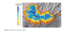
The Coropuna glacier is located 155 kilometres (96 mi) northwest of Arequipa.[43] Exceeded in size solely by the Quelccaya ice cap, it is the second-largest tropical ice cap in the world.[44] The highest point of the Coropuna ice cap is measured at 6,446 metres (21,148 ft) altitude.[43] A 2010 study showed the average thickness was 80.8 ± 16.5 metres (265 ± 54 ft), with a total volume of 4.62 ± 0.94 cubic kilometres (1.11 ± 0.23 cu mi).[45] In 1962 at least 17 glaciers combined to form this ice cap.[6] Present-day outlet glaciers reach down to 5,500 metres (18,000 ft) and 5,100 metres (16,700 ft) on the southern and northern side, respectively.[10] The northeastern glaciers are smaller than the southeastern ones.[46] Beneath the glacier above 4,500 metres (14,800 ft) altitude, gelifluction and other periglacial features form the terrain.[12] No significant valley glaciers are present on Coropuna.[7]
There is evidence of glaciation during the Coropuna I stage of volcanic activity;[25] the mountain was glaciated at least since the Pliocene.[27] During the Last Glacial Maximum, Coropuna's longest glacier was the 12-kilometre (7.5 mi)-long Quebrada Ullulo glacier, and the ice cap covered a surface area of at least 365 square kilometres (141 sq mi). Outlet glaciers descended to 4,540 feet (1,380 m) and 3,780 metres (12,400 ft) altitude on the northern and southern flank, respectively.[47] Equilibrium line altitudes ranged from 5,120–5,230 metres (16,800–17,160 ft) on the northern side to 4,700–4,800 metres (15,400–15,700 ft) on the southern side. Aside from a north–south gradient, a possibly wind sublimation-driven east–west gradient in equilibrium line altitudes is visible.[48] In addition to Ullulo on the northern flank, other outlet glaciers were Huayllaura and Quipchane on the southern flank, Pucunchiloyocc on the western flank, and Cospanjaon on the eastern flank.[10] Based on chlorine-36 accumulation data on moraines, it has been determined that the volcano underwent a major expansion between 20,000 and 16,000 years ago, a minor expansion 12,000 to 11,000 years ago, and another minor expansion 9,000 years ago. On the southern flank, a major expansion took place 14,000 years ago and a minor one 10,000–9,000 years ago. Evidence has been found of a later minor expansion 6,000 years ago.[29] It has been determined that in the late Holocene, the snowline was located at 5,200–5,775 metres (17,060–18,947 ft) of elevation.[49]

Coropuna's largest moraines were formed during the Last Glacial Maximum (LGM), about 25,000–20,000 years ago.[47] The Ullulo moraine on the northern flank is the largest, with a relief of 100 metres (330 ft).[50] Gravel and boulders form the bulk of the LGM moraines.[47] There are several stages of moraines between these LGM moraines and the present-day ones, some linked to the late 19th-century advance and other more extensive ones to late glacial advances. All of these moraines are crisp and have been well preserved by the arid conditions.[10] The moraines within 0.5 kilometres (0.31 mi) of the present-day ice margin are steep-sided.[14] The current retreat has left small and poorly developed terminal moraines.[51]
In 1970 Coropuna's glaciers formed 4% of Peru's total glacier surface.[52] The Coropuna ice cap has shrunk between 1955 and 2008,[53] from 122.7 square kilometres (47.4 sq mi) to 48.1 square kilometres (18.6 sq mi) surface area.[54] Much of the surface loss happened in the 1980s and 1990s.[55] This shrinkage of 1.4 square kilometres (0.54 sq mi) per year may result in the disappearance of the ice cap by 2045.[56] The surface area of the ice cap as measured by satellite images decreased from 105 ± 16 square kilometres (40.5 ± 6.2 sq mi) in 1975 to 96 ± 15 square kilometres (37.1 ± 5.8 sq mi) in 1986, 64 ± 8 square kilometres (24.7 ± 3.1 sq mi)
in 1996, 56 ± 6 square kilometres (21.6 ± 2.3 sq mi) in 2003,[57] and to 47 square kilometres (18 sq mi) in 2007.[46] It is likely that some ice masses will disappear soon, while others will persist for decades.[46] Further, the snowline has risen much higher than the glacier termini.[49] This retreat mirrors the retreat of most glaciers in the world since the end of the Little Ice Age.[52]
Coropuna is drained by deep gorges, with water eventually reaching the Arma and Majes rivers, both of which empty into the Pacific Ocean.[6][37] During the dry season, Coropuna's glaciers are a major source of water for the region, and concern has been raised that their disappearance may result in water shortages at a time when population growth has increased water consumption and begun to create conflict over water distribution.[58] 30,000 people depend on the Coropuna glacier in one way or the other, 8,000 of them just for their water supply.[43]
A major ice core was drilled in 2003 on Coropuna, covering more than 16,000 years.[59] Ice cores indicate that the Coropuna glacier receives mostly continental dust,[60] and that 4,200 years ago there was a severe drought, while 5,200 years ago a wet and cold period occurred.[61] More recent data show a severe drought from 1790 to 1796.[62] Fossil remains of rock glaciers have been found on the southeastern flank at altitudes of 4,500–5,250 metres (14,760–17,220 ft).[63]
Climate and vegetation
Close to the ice, diurnal temperature variation dominates seasonal effects.[6] The temperature has generally increased in the area (0.1 °C (0.2 °F) per decade since 1939), with El Niño events possibly playing a role.[64] Analysis of plankton in Lake Titicaca indicates that a glacial climate prevailed until 10,000–9,000 years ago.[29]
Because of the rain shadow of the Andes and the temperature inversion over the Pacific, the climate is arid, with precipitation of 390 millimetres (15 in) per year at 6,080 metres (19,950 ft) altitude.[9] Water cannot reach Coropuna from the Pacific Ocean.[35] Most precipitation (70–90%) falls during summer (December–March). A sharp reduction in precipitation was found during the El Niño years of 1982–1983 and 1992.[65] These events were also accompanied by lower cloud cover, higher temperatures, and lower wind speed, increasing the glacier surface loss.[57] However, the El Niño of 1997–1998 was accompanied by high precipitation.[66] Precipitation mostly originates from the Atlantic Ocean via the Amazon basin.[67] Pollen data tend to be dominated by local species during dry spells. Occasionally, strong southern cold outbreaks reach Coropuna's latitudes.[60] As evidenced by the Sajsi (25,000–19,000 years ago), Tauca (18,000–14,000 years ago), and Coipasa (13,000–11,000 years ago) lake highstands, ice age humidity was much higher in the Altiplano.[25]
Based on mapping, in 1955 the equilibrium line altitude had a mean elevation of 5,687 ± 49 metres (18,658 ± 161 ft) but has since then risen by 80–90 metres (260–300 ft).[48] As is the case farther south in Chile, the snowline altitude is chiefly governed by precipitation and not by temperature.[63] Winds in the Coropuna area are chiefly from the east.[68]
Coropuna rises over the Puna, a grassland at an altitude of 4,000–4,800 metres (13,100–15,700 ft) that contains Asteraceae shrubs.[69] Local plant families and genera attested by pollen data are Asteroideae, Poaceae, and Polylepis.[60] Vegetation ends at 5,000 metres (16,000 ft) altitude. Beneath this line it is composed of Azorella compacta and ichu grass.[10] Cushion plants are also frequent around 5,000 metres (16,000 ft).[69] The arid climate means that the flora is highly xerophilic.[70] Marsh vegetation and a distinct peat bog are found in wetter parts of Coropuna's slopes. Polylepis woodlands are found on the southern slope.[71]
Religious and archaeological importance
In Inca mythology, Coropuna was identified as an Apu, a sacred mountain. An Inca path leading up the mountain has been found, with bones and pottery fragments up to 6,200 metres (20,300 ft).[72] Over thirty archaeological sites, many of them predating the Incas, have been found around Coropuna. The Inca sites are the highest ones, though some occur next to bogs such as the one next to the village Maucta Llacta.[73] The influence of human habitation on the environment is noticeable from 2,200 BP onward.[74]
The Inca used the waters of Coropuna, building an irrigation system that drew water from the glaciers at 5,600 metres (18,400 ft) altitude, the highest irrigation system in the world.[72]
See also
References
- 1 2 "Coropuna". Global Volcanism Program. Smithsonian Institution.
- 1 2 Bromley et al., 2011, p.305
- 1 2 Úbeda, Jose; Palacios, D.; Vázquez-Selem, Lorenzo. "La evolución glaciovolcánica del Nevado Coropuna desde la transición del Pleistoceno al Holoceno". researchgate.net (in Spanish). Lima, Peru: XVI Congreso Peruano de Geología. p. 4. Retrieved 26 February 2016.
- ↑ Thouret, Jean-Claude; Rivera, Marco; Wörner, Gerhard; Gerbe, Marie-Christine; Finizola, Anthony; Fornari, Michel; Gonzales, Katherine (21 April 2005). "Ubinas: the evolution of the historically most active volcano in southern Peru". Bulletin of Volcanology. 67 (6): 558. doi:10.1007/s00445-004-0396-0.
- ↑ Chuquibamba (32-q) (Map). 1:100,000. IGN (Instituto Geográfico Nacional, Peru).
- 1 2 3 4 Silverio et al., 2012, p.5878
- 1 2 3 4 5 de Silva et al., 1990, p.292
- 1 2 Weibel et al., 1978, p.245
- 1 2 3 4 5 6 Bromley et al., 2011, p.306
- 1 2 3 4 5 Bromley et al., 2011, p.307
- 1 2 3 Bullard, Fred M. (December 1962). "Volcanoes of Southern Peru". Bulletin Volcanologique. 24 (1): 444. doi:10.1007/BF02599360.
- 1 2 3 4 5 Weibel et al., 1978, p.246
- 1 2 3 Jose Úbeda Palenque, El clima, la vegetación y la evolución volcánica y glaciar del Nevado Coropuna, p.1
- 1 2 Bromley et al., 2011, p.309
- ↑ Peduzzi et al., 2009, p.840
- ↑ Racoviteanu et al., 2007, p.112
- ↑ de Silva et al., 1990, p.288
- ↑ Ubeda Palenque, José (2011) El impacto del cambio climático en los glaciares del complejo volcánico Nevado Coropuna, (Cordillera Occidental de los Andes Centrales). p.39
- ↑ Ubeda Palenque, José (2011) El impacto del cambio climático en los glaciares del complejo volcánico Nevado Coropuna, (Cordillera Occidental de los Andes Centrales). p.66
- ↑ Vatin-Pérignon, Nicole; Oliver, Richard A.; Goemans, Pierre; Keller, Francine; Briqueu, Louis; Guido Salas, A. (April 1992). "Geodynamic interpretations of plate subduction in the northernmost part of the Central Volcanic Zone from the geochemical evolution and quantification of the crustal contamination of the Nevado Solimana volcano, southern Peru". Tectonophysics. 205 (1–3): 330. doi:10.1016/0040-1951(92)90434-8.
- 1 2 3 4 Weibel et al., 1978, p.251
- ↑ Ubeda Palenque, José (2011) El impacto del cambio climático en los glaciares del complejo volcánico Nevado Coropuna, (Cordillera Occidental de los Andes Centrales). p.165
- ↑ Kaneoka, Ichiro; Guevara, Carlos (1984). "K-Ar age determinations of late Tertiary and Quaternary Andean volcanic rocks, southern Peru.". GEOCHEMICAL JOURNAL. 18 (5): 237. doi:10.2343/geochemj.18.233.
- ↑ Jose Úbeda Palenque, El clima, la vegetación y la evolución volcánica y glaciar del Nevado Coropuna, p.9
- 1 2 3 Jose Úbeda Palenque, El clima, la vegetación y la evolución volcánica y glaciar del Nevado Coropuna, p.10
- ↑ Ubeda Palenque, José (2011) El impacto del cambio climático en los glaciares del complejo volcánico Nevado Coropuna, (Cordillera Occidental de los Andes Centrales). p.95
- 1 2 3 4 Ubeda Palenque, José (2011) El impacto del cambio climático en los glaciares del complejo volcánico Nevado Coropuna, (Cordillera Occidental de los Andes Centrales). p.25
- ↑ Thouret, Jean-Claude; Davila, Jasmine; Etienne, Juvign; Lee, Alex; LEGELEY-PADOVANI, Annick; Loutsch, Isabelle; Majavesi, Medeia; Jersy, Marino; Moscol, Marcela. "LATE PLEISTOCENE AND HOLOCENE TEPHROSTRATIGRAPHY AND CHRONOLOGY IN SOUTHERN PERU". gsa.confex.com/gsa/inqu/finalprogram/. Reno, Nevada: XVI INQUA Congress. Retrieved 27 February 2016.
- 1 2 3 Úbeda, J.; Palacios, D.; Vázquez-Selém, L. "Glacial and volcanic evolution on Nevado Coropuna (Tropical Andes) based on cosmogenic 36Cl surface exposure dating". The SAO/NASA Astrophysics Data System. EGU General Assembly 2012. Retrieved 26 February 2016.
- ↑ Ubeda Palenque, José (2011) El impacto del cambio climático en los glaciares del complejo volcánico Nevado Coropuna, (Cordillera Occidental de los Andes Centrales). p.166
- ↑ Ubeda Palenque, José (2011) El impacto del cambio climático en los glaciares del complejo volcánico Nevado Coropuna, (Cordillera Occidental de los Andes Centrales). p.112
- ↑ Ubeda Palenque, José (2011) El impacto del cambio climático en los glaciares del complejo volcánico Nevado Coropuna, (Cordillera Occidental de los Andes Centrales). p.174
- ↑ Jay, J.; Pritchard, M.E.; Aron, F.; Delgado, F.; Macedo, O.; Aguilar, V. "Volcano-tectonic interactions at Sabancaya and other Peruvian volcanoes revealed by InSAR and seismicity". The SAO/NASA Astrophysics Data System. American Geophysical Union, Fall Meeting 2013. Retrieved 26 February 2016.
- ↑ Holtkamp, S. G.; Pritchard, M. E.; Lohman, R. B. (October 2011). "Earthquake swarms in South America". Geophysical Journal International. 187 (1): 139. doi:10.1111/j.1365-246X.2011.05137.x.
- 1 2 Jose Úbeda Palenque, El clima, la vegetación y la evolución volcánica y glaciar del Nevado Coropuna, p.2
- ↑ Ubeda Palenque, José (2011) El impacto del cambio climático en los glaciares del complejo volcánico Nevado Coropuna, (Cordillera Occidental de los Andes Centrales). p.29
- 1 2 DEGG, MARTIN R; CHESTER, DAVID K (June 2005). "Seismic and volcanic hazards in Peru: changing attitudes to disaster mitigation". The Geographical Journal. 171 (2): 135. doi:10.1111/j.1475-4959.2005.00155.x.
- 1 2 Venturelli et al., 1978, pp.214–215
- 1 2 Weibel et al., 1978, p.248
- ↑ Venturelli et al., 1978, pp.226
- ↑ Ubeda Palenque, José (2011) El impacto del cambio climático en los glaciares del complejo volcánico Nevado Coropuna, (Cordillera Occidental de los Andes Centrales). p.114
- ↑ Ubeda Palenque, José (2011) El impacto del cambio climático en los glaciares del complejo volcánico Nevado Coropuna, (Cordillera Occidental de los Andes Centrales). p.82
- 1 2 3 Peduzzi et al., 2010, p.314
- ↑ Ubeda Palenque, José (2011) El impacto del cambio climático en los glaciares del complejo volcánico Nevado Coropuna, (Cordillera Occidental de los Andes Centrales). p.24
- ↑ Peduzzi et al., 2010, pp.320–321
- 1 2 3 Úbeda, J.; Palacios, D.; Vázquez, L. "Reconstruction of Equilibrium Line Altitudes of Nevado Coropuna Glaciers (Southern Peru) from the Late Pleistocene to the present". The SAO/NASA Astrophysics Data System. EGU General Assembly 2009. Retrieved 26 February 2016.
- 1 2 3 Bromley et al., 2011, p.308
- 1 2 Bromley et al., 2011, p.312
- 1 2 Bromley et al., 2011, p.313
- ↑ Bromley et al. 2009, p.2518
- ↑ Bromley et al., 2011, p.310
- 1 2 Silverio et al., 2012, p.5876
- ↑ Peduzzi et al., 2010, p.313
- ↑ Peduzzi et al., 2010, p.318
- ↑ Kargel, Jeffrey S.; Leonard, Gregory J.; Bishop, Michael P; Kääb, Andreas; Raup, Bruce H (2014). Global Land Ice Measurements from Space. Springer Berlin Heidelberg. p. 616. ISBN 978-3-540-79818-7.
- ↑ Peduzzi et al., 2010, p.322
- 1 2 Silverio et al., 2012, p.5882
- ↑ Silverio et al., 2012, p.5877
- ↑ Gornitz, Vivien (2009). Encyclopedia of Paleoclimatology and Ancient Environments. Springer Netherlands. p. 458. ISBN 978-1-4020-4411-3. Retrieved 27 February 2016.
- 1 2 3 Herreros et al., 2009, p.32
- ↑ Thompson, L.G.; Mosley-Thompson, E.S.; Buffen, A.; Urmann, D.; Davis, M.E.; Lin, P. "Tropical Glaciers: Recorders and Indicators of Climate Change". The SAO/NASA Astrophysics Data System. American Geophysical Union, Fall Meeting 2008. Retrieved 26 February 2016.
- ↑ Thompson, L.G.; Mosley-Thompson, E.S.; Davis, M.E.; Urmann, D.; Buffen, A. "Ice Core Evidence for Amplification of the Recent Warming at High Elevations in the Tropics and the Likely Regional Impacts". The SAO/NASA Astrophysics Data System. American Geophysical Union, Fall Meeting 2007. Retrieved 26 February 2016.
- 1 2 Dornbusch, U. (1 January 2005). "Glacier-rock glacier relationships as climatic indicators during the late Quaternary in the Cordillera Ampato, Western Cordillera of southern Peru". Geological Society, London, Special Publications. 242 (1): 77. doi:10.1144/GSL.SP.2005.242.01.07.
- ↑ Silverio et al., 2012, p.5885
- ↑ Herreros et al., 2009, p.28
- ↑ Peduzzi et al., 2009, p.841
- ↑ Herreros et al., 2009, p.33
- ↑ Bromley et al. 2009, p.2515
- 1 2 Kuentz et al. 2011, p.1216
- ↑ Jose Úbeda Palenque, El clima, la vegetación y la evolución volcánica y glaciar del Nevado Coropuna, p.3
- ↑ Kuentz, Adèle; de Mera, Antonio Galán; Ledru, Marie-Pierre; Thouret, Jean-Claude (October 2007). "Phytogeographical data and modern pollen rain of the puna belt in southern Peru (Nevado Coropuna, Western Cordillera)". Journal of Biogeography. 34 (10): 1768. doi:10.1111/j.1365-2699.2007.01728.x.
- 1 2 Chávez Chávez, José Antonio (July 2001). "INVESTIGACIONES ARQUEOLÓGICAS DE ALTA MONTAÑA EN EL SUR DEL PERÚ". Chungará (Arica) (in Spanish). SciELO. 33 (2). doi:10.4067/S0717-73562001000200014. ISSN 0717-7356.
- ↑ Kuentz, Adèle; Thouret, Jean-Claude; Ledru, Marie-Pierre; Forget, Marie-Émilie (1 August 2011). "Sociétés andines et changements environnementaux depuis 4 000 ans dans la région du Nevado Coropuna (sud du Pérou)". Bulletin de l'Institut français d'études andines (40 (2)): 235–257. doi:10.4000/bifea.1388.
- ↑ Kuentz et al. 2011, p.1224
Sources
- Bromley, Gordon R.M.; Schaefer, Joerg M.; Winckler, Gisela; Hall, Brenda L.; Todd, Claire E.; Rademaker, Kurt M. (November 2009). "Relative timing of last glacial maximum and late-glacial events in the central tropical Andes". Quaternary Science Reviews. 28 (23–24): 2514–2526. doi:10.1016/j.quascirev.2009.05.012.
- Kuentz, A.; Ledru, M.-P.; Thouret, J.-C. (22 July 2011). "Environmental changes in the highlands of the western Andean Cordillera, southern Peru, during the Holocene". The Holocene. 22 (11): 1215–1226. doi:10.1177/0959683611409772.
- de Silva, SL; Francis, PW (March 1990). "Potentially active volcanoes of Peru-Observations using Landsat Thematic Mapper and Space Shuttle imagery". Bulletin of Volcanology. 52 (4): 286–301. doi:10.1007/BF00304100.
- Ubeda Palenque, José (2011). El impacto del cambio climático en los glaciares del complejo volcánico Nevado Coropuna, (Cordillera Occidental de los Andes Centrales) (in Spanish). Madrid: Universidad Complutense Madrid. ISBN 978-84-694-2060-7. Retrieved 26 February 2016.
- Racoviteanu, Adina E.; Manley, William F.; Arnaud, Yves; Williams, Mark W. (October 2007). "Evaluating digital elevation models for glaciologic applications: An example from Nevado Coropuna, Peruvian Andes". Global and Planetary Change. 59 (1–4): 110–125. doi:10.1016/j.gloplacha.2006.11.036.
- Peduzzi, P.; Herold, C.; Silverio, W. (23 August 2010). "Assessing high altitude glacier thickness, volume and area changes using field, GIS and remote sensing techniques: the case of Nevado Coropuna (Peru)". The Cryosphere. 4 (3): 313–323. doi:10.5194/tc-4-313-2010.
- Herreros, J.; Moreno, I.; Taupin, J.-D.; Ginot, P.; Patris, N.; De Angelis, M.; Ledru, M.-P.; Delachaux, F.; Schotterer, U. (13 October 2009). "Environmental records from temperate glacier ice on Nevado Coropuna saddle, southern Peru". Advances in Geosciences. 22: 27–34. doi:10.5194/adgeo-22-27-2009.
- Bromley, Gordon R.M.; Hall, Brenda L.; Rademaker, Kurt M.; Todd, Claire E.; Racovteanu, Adina E. (March 2011). "Late Pleistocene snowline fluctuations at Nevado Coropuna (15°S), southern Peruvian Andes". Journal of Quaternary Science. 26 (3): 305–317. doi:10.1002/jqs.1455.
- Weibel, M.; Frangipane-Gysel, M.; Hunziker, J. (February 1978). "Ein Beitrag zur Vulkanologie Süd-Perus". Geologische Rundschau (in German). 67 (1): 243–252. doi:10.1007/BF01803264.
- Silverio, Walter; Jaquet, Jean-Michel (20 September 2012). "Multi-temporal and multi-source cartography of the glacial cover of Nevado Coropuna (Arequipa, Peru) between 1955 and 2003". International Journal of Remote Sensing. 33 (18): 5876–5888. doi:10.1080/01431161.2012.676742.
- Úbeda-Palenque, Jose. "EL CLIMA, LA VEGETACIÓN YLA EVOLUCIÓN VOLCÁNICA Y GLACIAR DEL NEVADO COROPUNA". La Cultura Antipampa Pampacolca (in Spanish). Madrid. Retrieved 26 February 2016.
- Peduzzi, P.; Herold, C.; Silverio, W. (6 October 2009). "Assessing high altitude glacier volume change and remaining thickness using cost-e ffi cient scientific techniques: the case of Nevado Coropuna (Peru)" (PDF). The Cryosphere. Retrieved 26 February 2016.
- Venturelli, G.; Fragipane, M.; Weibel, M.; Antiga, D. (September 1978). "Trace element distribution in the cainozoic lavas of Nevado Coropuna and Andagua Valley, Central Andes of Southern Peru". Bulletin Volcanologique. 41 (3): 213–228. doi:10.1007/BF02597224.
Books
- Biggar, John (2005). The Andes: A Guide for Climbers (3rd ed.). Andes Publishing (Scotland). ISBN 0-9536087-2-7. 304 pp.
- González-Ferrán, Oscar (1995). Volcanes de Chile (in Spanish). Santiago, Chile: Instituto Geográfico Militar. ISBN 956-202-054-1. 640 pp. (also includes volcanoes of Argentina, Bolivia, and Peru)
- De Silva, Shanaka L.; Francis, Peter (1991). Volcanoes of the Central Andes. Springer-Verlag. ISBN 3-540-53706-6. 216 pp.
- "Coropuna". Global Volcanism Program. Smithsonian Institution.
- Reinhard, Johan (1999). "Coropuna: Lost Mountain Temple of the Incas." South American Explorers Journal 58: 5, 26–30.
- Reinhard, Johan (2005). The Ice Maiden: Inca Mummies, Mountain Gods, and Sacred Sites in the Andes. Washington, D.C.: National Geographic Society. ISBN 0-7922-6838-5.
- Ziólkowski, Mariusz (2008). "Coropuna y Solimana: Los Oráculos de Condersuyos." In Adivinación y oráculos en le Mundo Andino Antiguo, Curatola, Marco and Mariusz Ziólkowski (eds.), pp. 121–159. Fundo Editorial de la Pontificia Universidad Católica del Perú, Lima.
External links
| Wikimedia Commons has media related to Coropuna. |