Changuinola District
| Changuinola District | |
|---|---|
| District | |
|
| |
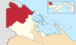 | |
 Changuinola District Location of the district capital in Panama | |
| Coordinates: 09°25′48″N 82°31′12″W / 9.43000°N 82.52000°WCoordinates: 09°25′48″N 82°31′12″W / 9.43000°N 82.52000°W | |
| Country |
|
| Province | Bocas del Toro Province |
| Capital | Changuinola |
| Area | |
| • Total | 1,542 sq mi (3,995 km2) |
| Population (2010) | |
| • Total | 98,310 |
| Time zone | ETZ (UTC-5) |
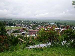
Changuinola District is a district (distrito) of Bocas del Toro Province in Panama. The population according to the 2010 census was 98.310 [1] The district covers a total area of 3,995 km². The capital lies at the city of Changuinola.[2] Major industries include tourism and agriculture.
Administrative divisions
The district is divided administratively into the following corregimientos:
Changuinola, Almirante, Guabito, Teribe, Valle del Risco, El Empalme, Las Tablas, Valle de Agua Arriba, Nance de Risco, Las Delicias, Cochigro and La Gloria.[3]
In 2015, Panamanian National Assembly authorized the split of Almirante Corregimiento to form a new District, but may require years for changes take effect.
Climate
Changuinola has a coastal location with a tropical climate. The area does not have a predictable dry season. The driest times are late August to mid-October, February, and March.[4] Changuinola is humid. Thundershowers and heavy rain are common.[5] Normal temperatures are consistent all year (Hi: 80°-84°F, low: 71°-75°F).[4] Due to its low latitude, sunrise is around 6 AM, and sunset is around 6 PM local time. These times vary slightly during the year. Weather data is collected at Captain Manuel Nino International Airport in Changuinola.[4]
| Climate data for Changuinola, Panama | |||||||||||||
|---|---|---|---|---|---|---|---|---|---|---|---|---|---|
| Month | Jan | Feb | Mar | Apr | May | Jun | Jul | Aug | Sep | Oct | Nov | Dec | Year |
| Average high °F (°C) | 80 (27) |
80 (27) |
82 (28) |
83 (28) |
83 (28) |
83 (28) |
82 (28) |
82 (28) |
84 (29) |
83 (28) |
81 (27) |
80 (27) |
81.9 (27.8) |
| Average low °F (°C) | 71 (22) |
71 (22) |
72 (22) |
73 (23) |
75 (24) |
75 (24) |
74 (23) |
74 (23) |
75 (24) |
75 (24) |
73 (23) |
72 (22) |
73.3 (23) |
| Average precipitation inches (mm) | 12.56 (319) |
7.90 (200.7) |
7.61 (193.3) |
11.30 (287) |
11.08 (281.4) |
10.87 (276.1) |
16.06 (407.9) |
11.37 (288.8) |
6.42 (163.1) |
7.80 (198.1) |
14.45 (367) |
15.81 (401.6) |
133.23 (3,384) |
| Source: Weather Underground [4] | |||||||||||||
References
- ↑ . Censos Nacionales 2010 Archived February 16, 2014, at the Wayback Machine.
- ↑ "Districts of Panama". Statoids. Retrieved April 10, 2009.
- ↑ . Gaceta Oficial 2009 Nuevos Corregimientos.
- 1 2 3 4 "Changuinola, Panama". Weather Underground. Retrieved 2009-05-29.
- ↑ Frommer's Panama (2E, 2009), ISBN 978-0-470-37183-1.

| Bocas del Toro Province | |
|---|---|
| Chiriquí Province | |
| Coclé Province | |
| Colón Province | |
| Darién Province | |
| Herrera Province | |
| Los Santos Province | |
| Panamá Province | |
| Veraguas Province | |
| West Panamá Province | |