Macaracas District
| Macaracas District | |
|---|---|
| District | |
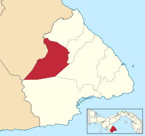 | |
 Macaracas District Location of the district capital in Panama | |
| Coordinates: 7°43′48″N 80°32′24″W / 7.73000°N 80.54000°W | |
| Country |
|
| Province | Los Santos Province |
| Capital | Macaracas |
| Area | |
| • Total | 195 sq mi (504 km2) |
| Population (2000) | |
| • Total | 9,137 |
| Time zone | ETZ (UTC-5) |
Macaracas District is a district (distrito) of Los Santos Province in Panama. The population according to the 2000 census was 9,137.[1] The district covers a total area of 504 km². The capital lies at the city of Macaracas.[1]
Administrative divisions
The district is divided administratively into the following corregimientos:
Macaracas (capital), Bahía Honda, Bajos de Guera, Corozal, Chupa, El Cedro, Espino Amarillo, La Mesa, Llano de Piedra, Las Palmas and Mogollón.

...
References
- 1 2 "Districts of Panama". Statoids. Retrieved April 12, 2009.
Capital: Las Tablas | ||
| Guararé District | 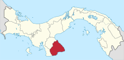 | |
| Las Tablas District | ||
| Los Santos District | ||
| Macaracas District | ||
| Pedasí District | ||
| Pocrí District | ||
| Tonosí District | ||
| Bocas del Toro Province | |
|---|---|
| Chiriquí Province | |
| Coclé Province | |
| Colón Province | |
| Darién Province | |
| Herrera Province | |
| Los Santos Province | |
| Panamá Province | |
| Veraguas Province | |
| West Panamá Province | |
Coordinates: 7°43′48″N 80°32′24″W / 7.73000°N 80.54000°W
This article is issued from Wikipedia - version of the 3/7/2016. The text is available under the Creative Commons Attribution/Share Alike but additional terms may apply for the media files.